
Bauler (Eifelkreis Bitburg-Prüm)
| coat of arms | Germany map | |
|---|---|---|

|
Coordinates: 49 ° 58 ' N , 6 ° 12' E |
|
| Basic data | ||
| State : | Rhineland-Palatinate | |
| County : | Eifel district Bitburg-Prüm | |
| Association municipality : | South Eifel | |
| Height : | 445 m above sea level NHN | |
| Area : | 6.04 km 2 | |
| Residents: | 66 (Dec. 31, 2019) | |
| Population density : | 11 inhabitants per km 2 | |
| Postal code : | 54673 | |
| Area code : | 06524 | |
| License plate : | BIT, PRÜ | |
| Community key : | 07 2 32 008 | |
| Association administration address: | Pestalozzistraße 7 54673 Neuerburg |
|
| Website : | ||
| Mayoress : | Marianne Milbert | |
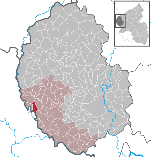
| Location of the local community Bauler in the Eifelkreis Bitburg-Prüm | ||
  |
||


Bauler is a municipality in the Eifelkreis Bitburg-Prüm in Rhineland-Palatinate . It belongs to the community of southern Eifel .
geography
The municipality lies on the border with Luxembourg north of Vianden . The residential area Neuscheuerhof and part of Gaymühle also belong to Bauler .
history
The place is mentioned in 1271 in the form de Berwitre , 1501 as Buler . In the property and pension specifications of Schloss Roth , a commenderie estate is listed in the 18th century. In 1768 a small chapel is reported in the Neuerburg parish archive.
Bauler belonged to the County of Vianden in the Duchy of Luxembourg until the end of the 18th century , and according to other sources it belonged to the Luxembourg rule of Falkenstein .
In 1794 French revolutionary troops occupied the Austrian Netherlands , to which the Duchy of Luxembourg belonged, and annexed it in October 1795 . Under French administration , the area belonged to the canton of Vianden in the Diekirch arrondissement , which was part of the department of forests .
Due to the resolutions at the Congress of Vienna in 1815, the former Luxembourg area east of the Sauer and Our was assigned to the Kingdom of Prussia . Under the Prussian administration, Bauler came to the Roth mayor's office in the Bitburg district , which was assigned to the Trier administrative district .
As a result of the Second World War, the Grand Duchy raised claims to the community of Roth and the adjacent Kammerwald as compensation for war damage suffered . In 1949 the municipality was administered by Luxembourg for a few years and belonged to Vianden . The claim was not officially abandoned until 1959 against other reparation payments.
After the First World War temporarily occupied by the French , the place was in the Second World War on the Siegfried Line . Since 1946 the place has been part of the state of Rhineland-Palatinate.
- Population development
The development of the population of Bauler, the values from 1871 to 1987 are based on censuses:
|
|
Municipal council
The municipal council in Bauler consists of six council members, who were elected by a majority vote in the local elections on May 26, 2019 , and the honorary local mayor as chairman.
Culture and sights
_06.jpg)
- Catholic branch church of St. Quirinus from 1768, a small hall building with a gable roof
- House in Sandbergstrasse 8/9 from 1809, with five-axis living area and two-axis bakery
- Westwall bunker
- Wooden bridge in the Gaytal
See also: List of cultural monuments in Bauler
literature
- Ernst Wackenroder (arr.): The art monuments of the Bitburg district (= Paul Clemen [Hrsg.]: The art monuments of the Rhine province . Volume 12 / I ). Trier 1983, ISBN 3-88915-006-3 , p. 246–247 (315 p., With 12 plates and 227 illustrations in the text. Reprinted by the Schwann edition, Düsseldorf 1927).
Web links
- To search for cultural assets of the Bauler community in the database of cultural assets in the Trier region .
Individual evidence
- ↑ State Statistical Office of Rhineland-Palatinate - population status 2019, districts, communities, association communities ( help on this ).
- ↑ State Statistical Office Rhineland-Palatinate (ed.): Official directory of the municipalities and parts of the municipality. Status: January 2019 [ Version 2020 is available. ] . S. 98 (PDF; 3 MB).
- ^ Wilhelm Fabricius : Explanations of the Historical Atlas of the Rhine Province, Die Karte von 1789 (2nd volume), Bonn 1898. P. 34
- ↑ Georg Bärsch : Description of the government district of Trier: according to official sources ... , Volume 1, Lintz, 1849, p. 88 ( Google Books )
- ^ A b Georg Bärsch: Description of the government district Trier: according to official sources ... , Volume 2, Lintz, 1846, p. 28 ( Google Books )
- ↑ State Statistical Office Rhineland-Palatinate: My village, my city. Retrieved August 1, 2019 .
- ^ The Regional Returning Officer Rhineland-Palatinate: Local elections 2019, city and municipal council elections. Retrieved August 1, 2019 .
Affler | Alsdorf | Altscheid | Ammeldingen on the Our | Ammeldingen near Neuerburg | Bauler | Berkoth | Berscheid | Biesdorf | Bollendorf | Castle | Dauwelshausen | Echternacherbrück | Eisenach | Emmelbaum | Ernzen | Ferschweiler | Fischbach-Oberraden | Geichlingen | Gemünd | Gentingen | Gilzem | Heilbach | Autumn Mill | Holsthum | Hommerdingen | Huts | Hüttingen near Lahr | Irrel | Karlshausen | Kaschenbach | Keppeshausen | Body | Koxhausen | Kruchten | Lahr | Leimbach | Menningen | Mettendorf | Minden | Muxerath | Nasingen | Neuerburg | Niedergeckler | Niederraden | Niederweis | Niehl | Walnut tree | Obergeckler | Peffingen | Plascheid | Prümzurlay | Rodershausen | Roth an der Our | Schankweiler | Log basket | Chafing | Sevenig near Neuerburg | Sinspelt | Überisenbach | Uppershausen | Utscheid | Waldhof-Falkenstein | Wallendorf | Weidingen | Doubt decision