
Doubt decision
| coat of arms | Germany map | |
|---|---|---|

|
Coordinates: 50 ° 2 ′ N , 6 ° 15 ′ E |
|
| Basic data | ||
| State : | Rhineland-Palatinate | |
| County : | Eifel district Bitburg-Prüm | |
| Association municipality : | South Eifel | |
| Height : | 370 m above sea level NHN | |
| Area : | 1.81 km 2 | |
| Residents: | 56 (Dec. 31, 2019) | |
| Population density : | 31 inhabitants per km 2 | |
| Postal code : | 54673 | |
| Area code : | 06564 | |
| License plate : | BIT, PRÜ | |
| Community key : | 07 2 32 138 | |
| Community structure: | 2 districts | |
| Association administration address: | Pestalozzistraße 7 54673 Neuerburg |
|
| Website : | ||
| Local Mayor : | Wilfried Balmes | |
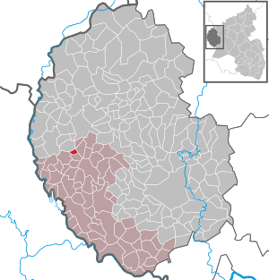
| Location of the community in Zweifelscheid in the Eifel district of Bitburg-Prüm | ||
  |
||

Doubtscheid is a municipality in the Eifelkreis Bitburg-Prüm in Rhineland-Palatinate . It belongs to the community of southern Eifel .
geography
The place is in the South Eifel nature park in the upper Enz valley . The north-lying hamlet of Engelsdorf is a district of Zweifelscheid, other parts of the municipality are Juckerstraße and Kokelsnaak.
Doubtscheid has an area of 181 hectares , 69 percent of which is used for agriculture, 24 percent is forest area.
history
Doubtscheid was first mentioned in 1539 as Tzwyvelschent .
Until the end of the 18th century, the place belonged to the lordship of Neuerburg in the Duchy of Luxembourg and was subordinate to the Koxhausen dairy . As a result of the French Revolutionary Wars , the Austrian Netherlands , to which Luxembourg then belonged, was incorporated into the French state in 1795 . Doubtscheid was assigned to the canton of Neuerburg in the department of forests .
As a result of the resolutions at the Congress of Vienna , the former Luxembourg area east of the Sauer and Our rivers became part of the Kingdom of Prussia in 1815 . Doubtscheid belonged to the mayor's office in Ammeldingen in the district of Bitburg, newly established in 1816, in the Trier administrative district , which was part of the Rhine province from 1822 on .
After the First World War , the area belonged to the French part of the Allied occupation of the Rhineland . After the Second World War , Zweifelscheid became part of the then newly formed state of Rhineland-Palatinate within the French occupation zone .
In terms of the church, Zweifelscheid is a branch of the Karlshausen parish .
- Population development
The development of the population of Zweifelscheid, the values from 1871 to 1987 are based on censuses:
|
|
politics
Municipal council
The municipal council in Zweifelscheid consists of six council members, who were elected by a majority vote in the local elections on May 26, 2019 , and the honorary local mayor as chairman.
coat of arms
|
|
Blazon : "From gold to red over a silver shield base with blue wavy bars divided by oblique-left red-silver strips, above black, triple tinned tunnel portal with a silver tunnel, below three golden ears."
The coat of arms was approved in September 2010 by the district administration of the Eifelkreis Bitburg-Prüm . |
| Justification of the coat of arms: The colors red and silver document the earlier affiliation to the Luxembourg rule of Neuerburg . The tunnel portal in black indicates the 127 m long Zweifelscheider tunnel, the three pinnacles to the three districts. The blue wavy band symbolizes the Enz , the three ears of wheat symbolize agriculture. |
Culture and sights

- Small Enz waterfall
- Enztal-Radweg (Eifel) - former railway line that was converted into a bicycle and hiking trail
- Leisure facility on the former station area
- Neuerburg Castle is about 6 km from the village
traffic
The community is accessed through Kreisstraße 58 .
Personalities
- Valentin Brück (1911–1980), politician (CDU), member of the German Bundestag
Web links
- In this country: Portrait of the village in Zweifelscheid. ( Memento from April 19, 2016 in the web archive archive.today ) Landesschau Rheinland-Pfalz, SWR TV
- To search for cultural assets of the local community Zweifelscheid in the database of cultural assets in the Trier region .
Individual evidence
- ↑ State Statistical Office of Rhineland-Palatinate - population status 2019, districts, communities, association communities ( help on this ).
- ↑ State Statistical Office Rhineland-Palatinate (ed.): Official directory of the municipalities and parts of the municipality. Status: January 2019 [ Version 2020 is available. ] . S. 101 (PDF; 3 MB).
- ^ A b State Statistical Office Rhineland-Palatinate: My village, my city. Retrieved August 7, 2019 .
- ^ The Regional Returning Officer Rhineland-Palatinate: Local elections 2019, city and municipal council elections. Retrieved August 7, 2019 .
- ↑ Coats of arms, flags, flags in the Verbandsgemeinde Südeifel , p. 60 (PDF, 6.8 MB)
- ↑ Cycle path through Zweifelscheid. Retrieved January 17, 2018 .
Affler | Alsdorf | Altscheid | Ammeldingen on the Our | Ammeldingen near Neuerburg | Bauler | Berkoth | Berscheid | Biesdorf | Bollendorf | Castle | Dauwelshausen | Echternacherbrück | Eisenach | Emmelbaum | Ernzen | Ferschweiler | Fischbach-Oberraden | Geichlingen | Gemünd | Gentingen | Gilzem | Heilbach | Autumn Mill | Holsthum | Hommerdingen | Huts | Hüttingen near Lahr | Irrel | Karlshausen | Kaschenbach | Keppeshausen | Body | Koxhausen | Kruchten | Lahr | Leimbach | Menningen | Mettendorf | Minden | Muxerath | Nasingen | Neuerburg | Niedergeckler | Niederraden | Niederweis | Niehl | Walnut tree | Obergeckler | Peffingen | Plascheid | Prümzurlay | Rodershausen | Roth an der Our | Schankweiler | Log basket | Chafing | Sevenig near Neuerburg | Sinspelt | Überisenbach | Uppershausen | Utscheid | Waldhof-Falkenstein | Wallendorf | Weidingen | Doubt decision