
Enztal Cycle Path (Eifel)
| Enztal cycle path | |
|---|---|
|
|
|
| overall length | approx. 46 km |
| location | Enz , Eifel / Rhineland-Palatinate |
| map | |
| Link to map and elevation profile | |
| Starting point | Pronsfeld |
| Target point | Holsthum |
| Places along the way | Station Üttfeld , hoof , Arzfeld , Neurath , Zweifelscheid , New Castle , Sinspelt , Mettendorf , Enzen , Peffingen |
| Flooring | asphalted cycle paths and farm roads, country roads |
| Height difference | Start 379 m , highest point 480 m , end 202 m approx. 370 m up / approx. 530 m down |
| difficulty | On 10 km approx. 1.5% gradient, then a slight gradient, an ascent between Enzen and Peffingen. |
| Traffic volume | 25 km of railway cycle paths, quiet country roads. |
| Connection to | Prümtal-Radweg , Eifel-Ardennen-Radweg |
| Website URL | eifel.info |
The Enztal-Radweg (also Enz-Radweg) is a cycle path in the southern Eifel that leads from Pronsfeld over the former route of the Enztalbahn , a branch line of the Westeifelbahn , into the Enztal to Enzen. Then it leaves the Enz valley and ends at Holsthum on the Prümtal cycle path . Together with the Prümtal cycle path, you can plan a round tour through the southern Eifel. The route is also indicated as being suitable for casual cyclists and families.
Route Pronsfeld - Holsthum
Characteristic
The Enztal Cycle Path uses a former railway line from Pronsfeld, the former railway junction and today's cycle path node to Neuerburg (25 km). This section has been completely paved since 2011. For the first 10 km, the route climbs with a 1.5% gradient from 379 m to 530 m . Then it continues with a slight incline to Neuerburg at the end of the former Enz Valley Railway. The next 20 km are paved roads with a slight incline through the Enz Valley. At the transition from the Enztal to the Prümtal, there is still an ascent to overcome. On two sections Neuerburg - Daudistel (2 km) and Enzen - Holsthum (5 km) you have to switch to the more heavily traveled L4 road. Separate cycle paths are being planned for these sections. The last section can be avoided by switching to the Prümtal cycle path in Peffingen. The route is also indicated as being suitable for casual cyclists and families. The ADFC classifies them as follows
- Surface approx. 40% suitable for racing bikes, approx. 60% for touring bikes.
- The difficulty is given as approx. 40% easy, approx. 60% medium (from: easy 0–2%, medium 2–6%, difficult 6–10%, sporty> 10%).
- The traffic load as "none to low" (from: "none to low", moderate, high)
Pronsfeld - Neuerburg
The Enztal cycle path starts at the former railway and today's cycle path junction Pronsfeld. This junction can be reached via the Eifel-Ardennes cycle path or the Prümtal cycle path. The two cycle paths run between Prüm and Pronsfeld together over the former route of the Westeifelbahn . The first approx. 1.5 km of the Enztal cycle path are covered together with the Prümtal cycle path, before the route near the Eifel Zoo changes over to the route of the Enztal railway with a short ascent (approx. 30 meters in altitude at 250 m) . From here you have a good panoramic view of the Islek plateau . The route then runs with a slight incline through the Kelsbachtal to the former Üttfeld train station. The road to Euscheid is crossed on a large viaduct. The route now makes a large curve from west to south and reaches the former station of Arzfeld. The route is characterized by a large number of old and new bridges. With Arzfeld the cycle path reaches the Enz valley and the slight ascent that has prevailed up to now is replaced by a slight incline. In the Enztal, almost tunnel-like overgrown stretches alternate with open terrain. The end point of the railway line in Neuerburg is reached via Zweifelscheid. This section leads through two illuminated tunnels, the Weidendell tunnel (125 m) and the Neuerburg tunnel (117 m).
Neuerburg - Holsthum
The rest of the route leads through the Enz Valley on farm roads and country roads. At Sinspelt the landscape changes. The route leaves the deeply cut valley where the Enz reaches the extensive Bitburger Gutland . The landscape is now dominated by sun-drenched orchards . The route leads through the Enz-Aue with the picturesque Eifel villages Mettendorf and Enzen. Then you reach Holsthum in the Prümtal via a ridge, where the Prümtal Cycle Path connects.
Sights, landscape and culture

Köf II with flat goods wagons as a memorial in Pronsfeld

Former Uttfeld train station
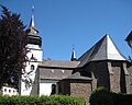
Parish church in Arzfeld

Enz waterfall in Neuerburg

The Huwelslay in Peffingen

Holsthum Castle


The area around Arzfeld belongs to the Islek region . A cross-border region in the border triangle of Germany, Luxembourg and Belgium. The region is characterized by deeply cut river valleys and biotopes with more northern or alpine vegetation through to extremely warmth-loving plant communities in sun-exposed locations. Small idyllic villages and secluded farms characterize the settlement.
-
Pronsfeld : With the former Pronsfeld railway junction one enters a place where railway history was written. The Westeifelbahn was opened in 1886 and supraregional destinations could be reached from the region. In 1907 the branch lines to Waxweiler and Neuerburg were put into operation, making Pronsfeld a railway junction. In addition to regional development, the planners also had military goals in mind. During the First World War, the route for the transport of supplies to the Western Front was further expanded and during the construction of the Western Wall (1936) the Pronsfeld station was one of the largest transshipment points for the construction material of the bunkers and barriers. To commemorate the earlier importance of the Pronsfeld station, an old shunting locomotive was erected as a memorialat the former Pronsfeld station in 2006.
Other sights in Pronsfeld are: The St. Remigius Church with the choir room and remains of the tower from the construction period around 1498. The Eifelzoo Pronsfeld enables the observation of native and exotic animals as well as a ride with its own zoo train through the facilities.
-
Neuerburg : Neuerburg Castle with fortifications: In 1926, the New Germany Youth Union took overthe crumbled remains and turned them into a youth hostel .
Black picture: A 46 cm high wooden figure in a 700 year old oak tree ruin, donated by Kuno von Falkenstein , became a pilgrimage picture. She resembles the Black Mother of God von Altötting . Plague
cross: The plague cross ,richly decorated on the shaft, a niche cross, reminds of the epidemics of the city, most recently in 1636.
Eligius Chapel: The chapel from 1437 and the Eligius fountain remind of St. Eligius .
Market fountain: The more recent bronze work by the Aachen artist Bonifacius Stirnberg shows the city's club life and traditional handicrafts.
- Holsthum : Holsthum Castle ; Hop fields on the bike path.

Connecting cycle paths
In Pronsfeld, the Enztal-Radweg branches off from the Eifel-Ardennen-Radweg and follows the route of the former branch line Pronsfeld – Waxweiler for the first kilometer together with the Prümtal-Radweg , before it separates from this and changes to the route of the former Enztalbahn . The entire Eifel between Ahr , Moselle and Rhine is accessible via the Eifel-Ardennes cycle path and its connecting routes . In Holsthum, the Enztal cycle path joins the Prümtal cycle path again. This ends in Minden on the Sauertal cycle path and thus enables the continuation towards the Moselle.
see also:
Train and bus connections
Unfortunately, the Enztal Cycle Path has no direct connection to train or bus lines with bicycle transport. The closest to Pronsfeld is Gerolstein, which can be reached by bike using public transport. The rest of the journey by bike can then take place via the Eifel-Ardennes cycle path (approx. 40 km). Gerolstein is on the Eifel route Cologne - Trier or Koblenz. In addition, rail buses and reconditioned passenger trains of the Vulkan-Eifel-Bahn (VEB) have been running on the Kaisersesch - Daun - Gerolstein route of the former Eifelquerbahn since 2000. Operation every two hours is limited to the season from May to October on weekends and public holidays. Gerolstein is also the end point of the RegioRadler bus line 500 from Cochem on the Moselle via Daun . The situation is better at the other end of the Enztal cycle path. Here you can travel by public transport via Irrel using the RegioRadler bus line 441 Sauertal ( Trier - Bollendorf , exit Irrel). The connection to Holsthum (approx. 10 km) is then made by the Prümtal cycle path. The “ RegioRadler ” bus routes run daily from April 1st to November 1st and have space for 22 bicycles.
literature
- ADFC regional map Eifel / Mosel , 1: 75,000. Bielefelder Verlag, 1st edition 2006. ISBN 3-87073-391-8
- Cycle Atlas Cycle Atlas "South Eifel" - between the Ardennes and the Vulkaneifel , 1: 75,000. Esterbauer publishing house. ISBN 978-3-85000-269-1
Web links
- Enztal cycle path: south of Pronsfeld - Arzfeld - Neuerburg , at www.achim-bartoschek.de
- Info boards:
- From rail to bike path (PDF file; 970 kB)
- The Pronsfeld railway junction (PDF file; 1.09 MB)
- Information on the Enztal cycle path with data to download
- ADFC overview: Eifel cycle paths ( Memento from March 4, 2016 in the Internet Archive ) (PDF file; 739 kB)
- Connection to RegioRadler buses in Rhineland-Palatinate
swell
- Radwanderland.de , accessed December 2011
Coordinates: 50 ° 9 ′ 36.1 ″ N , 6 ° 19 ′ 58.6 ″ E