
Eifel-Ardennes cycle path
| Eifel-Ardennes cycle path | |
|---|---|
|
|
|
| overall length | approx. 112 km |
| location | Ardennes , Eifel / Belgium , Rhineland-Palatinate |
| map | |
| Link to map and elevation profile | |
| Starting point | Nürburgring |
| Target point | St. Vith |
| Places along the way | Nürburg , Kelberg , Daun ( EB ), Gerolstein ( EB ), Prüm ( Bf ), Pronsfeld , Bleialf ( Bf ) |
| Flooring | Prüm - St. Vith: asphalt, otherwise: roads and paved paths |
| Height difference | Start 300 m , end 450 m +1500 m up / −1400 m down |
| difficulty | Prüm - St. Vith: easy / Nürburgring - Prüm: sporty |
| Traffic volume | Prüm - St. Vith: own bike paths / Nürburgring - Prüm: farm roads, roads with little traffic. |
| Connection to | Vulkan-Rad-Route Eifel , Mineralquellen-Route , Maare-Moselle-Radweg , Kosmosradweg , Kylltal-Radweg , Nimstal-Radweg , Prümtal-Radweg , Enztal-Radweg , Vennbahn |
| Website URL | eifel.info |
The Eifel-Ardennen-Radweg is a cycle route . It connects the Nürburgring in the Vulkaneifel with St. Vith in the Belgian Ardennes. The eastern part of the route, from the Nürburgring via Daun and Gerolstein to Prüm, is characterized by deep cuts and steep climbs. On the western, 37 km long section from Prüm to St. Vith, a well-developed railway cycle path has now been opened, so that this part is also recommended for family cyclists. Together with the Vulkan-Rad-Route Eifel and Ahrtal-Radweg in the east, the path creates a west-east bike route through the entire Eifel.
Route Nürburgring - Sankt Vith
Characteristic
The Eifel-Ardennen cycle path is marked in both directions with the cycle path logo in the German part and can be divided into three sections according to its characteristics.
- Eastern section: (Nürburgring - Gerolstein): Those who cycle on the Vulkan-Rad-Route Eifel from the Ahr valley to the Nürburgring, where the signs begin, are already at approx. 610 m above sea level. NHN climbed. From here it goes down the next 7 km to 410 m above sea level. NHN , before the next long slope behind Kelberg again to an altitude of 610 m above sea level. NHN leads. Now it is slightly hilly, but with a falling tendency, up to 400 m above sea level. NHN to Daun . Between Daun and Gerolstein there is another ridge with 623 m above sea level. To overcome NHN . This approx. 50 km long section is led on farm roads, district and municipal roads. The route is recommended for trained cyclists based on the climbs to be mastered.
- Middle section (Gerolstein - Prüm): For this approx. 25 km long section the expansion, on or on, of the former railway line of the Westeifelbahn is planned. Currently (2011) the cycle path near the railway line is run on farm roads, district and municipal roads. After Gerolstein ( 358 m above sea level ) there is an approx. 5 km long ascent to ( 450 m above sea level ) to Müllenborn . After a short descent, it goes steadily upwards again ( 534 m above sea level ) to Weinsheim , before the downhill section leads to Prüm ( 420 m above sea level ).
(Length: 24.9 km; altitude difference upwards +344 m; altitude difference downwards −275 m)
- Western section: It consists of the approximately 37 km long railway cycle path , which was completed in 2007 and runs on the former West Eifel Railway between Prüm and St. Vith . The route leads with a slight gradient from Prüm to 420 m above sea level. NHN to Pronsfeld at 370 m above sea level. NHN . Then continue slightly uphill to the former Bleialf train station at 460 m above sea level. NHN . This is followed by the 400 m long illuminated Bleialfer tunnel . This is closed from mid-October to the end of March to protect the bats that live there. During this time, a ridge with a height of approx. 500 m above sea level has to be reached. NHN and steep gradients are overcome. Then it goes with a slight long slope to the German-Belgian border in Steinebrück at 370 m above sea level. NHN . On the Belgian side, the route continues on the Ravel cycle route L46 to Lommersweiler and from there on the L47 to St. Vith. The route is partly guided on the old railway line via combined footpaths / bike paths and farm roads as well as connecting pieces on district and municipal roads and an approx. 100 m long tunnel. This section is also recommended for families with children.
(Length: 36.2 km; vertical meters upwards approx. +300 m; altitude meters downwards approx. −250 m)
description
Nürburgring - Gerolstein
The signs for the Eifel-Ardennen-Radweg start at the Nürburgring on the Vulkan-Rad-Route Eifel and follow it to Kelberg . Here the two paths separate. The volcano bike route runs over Mosbruch and Ulmen to its end point in Bullay on the Moselle , while the Eifel-Ardennes bike path continues to climb, its first mountain range at 610 m above sea level. NHN overcomes. The next place that is reached is after approx. 10 km Darscheid at 590 m above sea level. NHN . The route then continues down to the spa and district town of Daun . This is where the Maare-Moselle cycle path starts as a railway cycle path to Bernkastel-Kues on the Moselle. Furthermore, you have a connection to the Kosmosradweg , the Mineralquellen-Route , which together with the Kalkeifel-Radweg leads into the Kylltal , and with the Wittlicher Senke cycle path there is another connection to the Moselle valley . After the core town of Daun, a small ridge has to be overcome before it is a long slope through the villages of Neunkirchen , Steinborn , Waldkönigen at 600 m above sea level. NHN goes. The following descent then leads through the villages of Hinterweiler , Kirchweiler , Berlingen and Pelm to Gerolstein . The mineral fountain city of Gerolstein offers the Kasselburg with the “Adler- und Wolfspark Kasselburg”, the Erlöserkirche , the Löwenburg as well as the Lissingen castle and the Roman “Villa Sarabodis” , while the natural history museum shows the eventful geological past of the region. In Gerolstein there is a connection to the Kylltal cycle path , which leads from the source of the Kyll on the German-Belgian border to the Moselle and Trier. Both cycle paths run through Gerolstein's core town. The Gerolstein railway station is at the Eifel circuit ( Cologne - Euskirchen -Gerolstein- Trier ), which also accompanies the Kylltal bike path. In the summer season there are cycling buses between Daun and Gerolstein and the Vulkan-Eifel-Bahn (VEB) on weekends and public holidays .
Gerolstein - Prüm
For this section it is planned to extend the railway cycle path of the western section. So far (2011) the route follows the former route of the Westeifelbahn , which ended in Gerolstein. Behind Gerolstein, between the districts of Lissingen and Müllenborn, a ridge with about 100 meters of altitude has to be overcome before, after a descent to Oos , it goes up slightly to Büdesheim . The route then leads through hilly, rising terrain, passes the towns of Schwirzheim and Gondelsheim , before the highest point of the section at 534 m above sea level. NHN near Weinsheim is reached. The subsequent descent leads past Dausfeld to Prüm . In Prüm, the Basilica of Saint Salvator and the associated Baroque Abbey of Prüm are worth seeing.
Prüm - St. Vith
The cycle path, which was completed in 2007 and follows the route of the former West Eifel Railway, starts at the former Prüm train station . The route leads about 7 km along the route, with a slight gradient to the former Pronsfeld railway junction . The Prümtal cycle path also uses this section of the railway line and then branches off towards the south to Waxweiler . Before that, the river Prüm is crossed and the Prüm valley bridge of the A 60 leads near Weinsfeld high above the cycle path. The places Watzerath and Pittenbach are also passed, then Pronsfeld is reached. There is a railway memorial right on the bike path that reminds of the former railway junction. The route then leads with a slight ascent to the northwest, through the near-natural valley of the Alfbach , where beavers have settled. The A 60 then crosses the Alfbachtal and is driven under again. Afterwards, the cycle route uses a 1.5 km farm road away from the railway line. At Bleialf the route leaves the Alfbachtal after approx. 10 km and reaches the highest point. Then it goes slightly downhill again, in a westerly direction to the German-Belgian border in the Ourtal . Behind the former Bleialf train station, the winter bypass of the tunnel that now follows branches off to the right. The 400 meter long, illuminated tunnel is closed from November to March and serves as winter quarters for the bats. During this time, the bypass route over the ridge must be used. The route leads through the Ihrenbachtal where there is also a beaver colony. Through the village of Ihr it goes to the border river Our. Here, on the foundations of the railway bridge that was blown up in 1944, rests the wooden bridge of the cycle and footpath that leads to the Belgian side. Here the cycle route connects to the Ravel cycle path network of East Belgium. The path, now marked as Ravel cycle route L46, continues on the former railway line through the Braunlauftal and meets the Ravel line L47 (Vennbahn cycle path) near Lommersweiler. The same route now leads along the same railway line through the approx. 100 m long tunnel near Neidingen to St. Vith. The St. Bartholomew chapel from the 9th century is located in the St. Vither district of Wiesenbach .
Connecting cycle paths
The Eifel-Ardennen-Radweg branches off at Kelberg from the Vulkan-Rad-Route Eifel , which connects the Ahr valley with the Moselle. The Rhine, which forms the eastern border of the Eifel, can be reached both via the Ahr cycle path and the Moselle cycle path . In Daun there are then further connection options. Via the mineral spring route and its extension, the Kalkeifel cycle path , it is possible to reach the upper Ahr valley or the Kyll valley near Hillesheim . The Maare-Moselle cycle path starts here as a railway cycle path to Bullay on the Moselle. There is also a connection to the Kosmos cycle path as a themed route. In Gerolstein , the route runs together with the Kylltal cycle path , which starts from the source and reaches the Moselle near Trier . The headwaters of the Nims are located in Weinsheim just before Prüm , in the so-called Prümer Kalkmulde . This is where the Nimstal cycle path starts up to the confluence with the Prüm near Irrel . Between Prüm and Pronsfeld, the railway line is used together with the Prümtal cycle path . This connects the Prüm source with the confluence with the Sauer near Minden . The Enztal cycle path also starts in Pronsfeld, some of which leads along a former railway line to Holsthum . In Belgium there is a connection to the Belgian cycle path network , the RAVeL network and the historic Vennbahn cycle path .
Train and bus connections
The first station on the route described is the Eifelquerbahn stop in Darscheid and shortly afterwards in Daun . On the Kaisersesch - Darscheid - Daun - Pelm - Gerolstein line of the former Eifelquerbahn, rail buses and reconditioned passenger trains of the Vulkan-Eifel-Bahn (VEB) have been running since 2000 . Operation every two hours is limited to the season from May to October on weekends and public holidays. The Gerolstein train station is also on the Eifel route Cologne - Trier or Koblenz.
The “ Regioradler Vulkaneifel ” RegioLine 500 bus line runs daily from April 1st to November 1st between Cochem on the Moselle and Gerolstein in the Vulkaneifel and also connects Ulmen and Daun on the way. This bus line has space for 22 bicycles.
Landscape and culture

Nürburgring, Grand Prix track

Railway viaduct in Daun
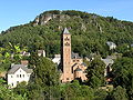
Church of the Redeemer in Gerolstein

Abbey with St. Salvator's Basilica in Prüm

East portal of the Bleialfer tunnel

Saint Bartholomew Chapel near Saint Vith

.jpg)


The route starts in the Vulkaneifel with its volcanic landscape, crosses parts of the Kalkeifel before it crosses the flat spring valleys of Nims and Prüm and leads into the Ardennes area. Behind Kelberg, the route follows an old Roman military road that ran on the watershed between the Moselle and Ahr. The rivers Lieser , Üß and Elz , which flow into the Moselle, arise in this water-rich area , while the Trierbach flows to the Ahr. The route then reaches the region in Daun, where massive volcanic eruptions more than 10,000 years ago shaped the unique landscape. The Dauner Maare, only 2.5 km to 3.5 km southeast of the city center of Daun, are particularly striking . Three directly adjacent maars, which are only separated by their tuff walls: the Gemündener Maar , the Weinfelder Maar and the Schalkenmehrener Maar . A visit to the Eifler volcano museum in the spa and district town of Daun enables a journey into this fiery past with the help of interactive computer simulation. After Daun there is another ridge, the highest point of which is in the wooded area around Waldkönigen , before the descent leads through agricultural terrain to Gerolstein . The Church of the Redeemer, built from 1911 to 1913 in the neo-Romanesque style, stands in Gerolstein . It was built by the Berlin Church Building Association and is considered a rare art-historical document from the imperial era. Inside the church is decorated with blue and gold colored mosaics in the Byzantine style. During the construction work, a Roman villa was discovered: a manor house with extensive bathing facilities. Today the valuable relics of Roman-Celtic culture from the 1st to 4th centuries can be viewed in the “Villa Sarabodis” museum. After Gerolstein, the path leads back up to the wooded heights of the Müllenborn district and continues up to the “Prümer Kalkmulde” area, whose underground rock consists of calcareous sediments from former seas. In the climatically drier and warmer Kalkeifel there are significant and scenic nature reserves, such as the Niesenberg nature reserve near Weinsheim . These habitats, which are considered ecologically valuable, also offer a great wealth of fossils. Above all, the areas covered with poor grass are habitats for protected animal and plant species. The source streams of the Nims arise in this area and disappear again in the subsurface in cavities that have been detached from the limestone layers. From the height of the nature reserve, the path then leads down to the town of Prüm, which has a lot to offer in terms of history and culture. The founding of the monastery of Prüm Abbey dates back to 721. King Pippin gave the abbey parts of Christ's sandals, which were then given the name Saint Salvator (To the Most Holy Redeemer). Charlemagne had the "Golden Church", consecrated in 799, built to store the precious relic. After the disintegration of this church, construction of today's basilica began in 1712. From 1748 a new abbey building was added to the church according to the plans of the baroque master builder Balthasar Neumann . Both buildings were only completed in 1912. Since then they have shaped the cityscape of Prüm. After Prüm the landscape is clearly different. In the place of ridges and deeply cut valleys are wide plateaus. The rivers and streams such as Kyll , Nims, Prüm and Alf form only shallow hollows on their upper reaches. Using the former railway line, the route leads through the gently undulating landscape with only slight inclines and declines. Only at the German-Belgian border does the valley of the Our have to be crossed again. When you reach the former Pronsfeld railway junction , you enter a place that wrote railway history. The Westeifelbahn was opened in 1886 and supraregional destinations could be reached from the region. In 1907 the branch line to Waxweiler and Neuerburg was put into operation, making Pronsfeld a railway junction. In addition to regional development, the planners also had military goals in mind. During the First World War, the route for the transport of supplies to the Western Front was further expanded and during the construction of the West Wall (1936) the Pronsfeld station was one of the largest transshipment points for the construction material of the bunkers and barriers.
Attractions
- Nürburg : Nürburg castle ruins ; Nürburgring racing track.
- Kelberg : This is where the history route “Around the Hochkelberg” starts; Town center with tree-lined market square; the parish church of St. Vinzenzius with the medieval west tower; restored half-timbered houses.
- Daun : Daun wildlife and adventure park; Daun Castle ; Catholic parish church of St. Nikolas ; Daun volcano museum ; Railway viaduct from 1909; the maars Gemündener Maar , Weinfelder Maar and Schalkenmehrener Maar ( see also: List of cultural monuments in Daun ).
- Gerolstein : The Kasselburg with the "Adler- und Wolfspark Kasselburg", where free flight exercises of golden eagles and falcons are shown. The Church of the Redeemer , which was a gift from the Berlin Church Building Association to Kaiser Wilhelm II . The Löwenburg and Lissingen Castle and the Roman "Villa Sarabodis" . The natural history museum in the old town hall shows the turbulent geological past of the region.
- Prüm : Saint Salvator's Basilica with Lothar I's grave and relics ( sandals of Christ ). Baroque Prüm Abbey based on plans by Balthasar Neumann with a magnificent portal and imperial hall. The rococo auditorium is part of the Regino high school today.
- Pronsfeld : St. Remigius Church with the choir room and remains of the tower from the construction period around 1498. To commemorate the earlier importance of the Pronsfeld station (here the branch lines to Arzfeld / Neuerburg and Waxweiler branched off from the main line of the Westeifelbahn )an old shunting locomotive was erected as a memorialat the former Pronsfeld station in 2006. The Eifelzoo Pronsfeld enables the observation of native and exotic animals as well as a ride with its own zoo train through the facilities.
- Bleialf : "Mühlenberger Stollen" visitor mine. Church of the Assumption from 1187.
- St. Vith : In the St. Vither district of Wiesenbach there is the St. Bartholomew chapelfrom the 9th century. It is the region's oldest cultural heritage.

literature
- ADFC regional map Eifel / Mosel , 1: 75,000. Bielefelder Verlag, 1st edition 2006. ISBN 3-87073-391-8
- Cycle Atlas Cycle Atlas "South Eifel" - between the Ardennes and the Vulkaneifel , 1: 75,000. Esterbauer publishing house. ISBN 978-3-85000-269-1
Web links
- Information on the Eifel-Ardennes cycle path with data to download
- Info boards:
- Mysterious wayside cross (PDF; 4.9 MB)
- Feuerberger to touch (PDF; 10.8 MB) ** Wilhelmine splendor on Roman soil (PDF; 7.4 MB)
- The Prümer Kalkmulde (PDF; 1.1 MB)
- The Basilica of St. Salvator (PDF; 981 kB)
- The Pronsfeld railway junction (PDF; 1.1 MB)
- From rail to cycle path (PDF; 993 kB)
- Bleialf - a traditional mining town (PDF; 959 kB)
- History of a border (PDF; 1.1 MB)
- Pictures of the western part at www.achim-bartoschek.de
swell
- Radwanderland.de Retrieved November 2011
Coordinates: 50 ° 19 ′ 53.3 " N , 6 ° 56 ′ 40.3" E