
Kalkeifel cycle path
| Kalkeifel cycle path | |
|---|---|
|
|
|
| overall length | 22 km |
| location | Eifel / Rhineland-Palatinate |
| map | |
| Link to map and elevation profile | |
| Starting point | Ahrdorf an der Ahr train station |
| Target point | Hillesheim-Bolsdorf on the Kyll |
| Places along the way | Ahütte , Niederehe , Kerpen , Walsdorf , Hillesheim |
| Flooring | asphalt or paved paths. |
| Height difference | Start 325 m , apex 475 m , end 400 m |
| difficulty | Railway path, short gradients of up to 5% |
| Traffic volume | almost entirely on a separate bike path |
| Connection to | Ahr cycle path , mineral springs route , Kylltal cycle path |
| Website URL | Kalkeifel cycle path at www.eifel.info |
The Kalkeifel cycle path is a cycle path that connects the cycle paths on the rivers Ahr and Kyll as a railway route. On the Ahr, it starts at the Ahrdorf train station northwards into the Eifel and after 22 km it reaches the Kyll valley and the Kyll cycle path near Hillesheim-Bolsdorf . With only a moderate incline, it crosses the Eifel landscape with the Eifel town of Kerpen and its imposing castle, the Romanesque monastery near Niederehe, the Dreimühlen waterfall and the European example town of Hillesheim. The cycle route is easily manageable by recreational cyclists. The route is uniformly marked in both directions with the bike path logo. The entire route was officially released on May 31, 2008. The route is not suitable for inline skaters as it is only partially paved.
Route Ahrdorf - Bolsdorf
The cycle path uses the route of the disused section Dümpelfeld - Ahrdorf - Hillesheim - Lissendorf of the Ahr Valley Railway for approx. 6 km . From the Ahr valley the route leads through the Ahbach valley with a moderate incline via Ahütte and Üxheim to Niederehe , which is reached after approx. 11 km. Here the mineral spring route branches off in the direction of Daun and thus connects the Ahr valley with the Maare-Mosel cycle path and the Moselle valley . The Dreimühlen waterfall near Üxheim is well worth seeing. The monastery with its Romanesque monastery church can be visited in Niederehe . After another two kilometers with a slight incline, the cycle path reaches Kerpen with its imposing castle . From Kerpen to Hillesheim , the route uses the old railway line. After about one kilometer of descent, it goes with a moderate incline via Walsdorf to just before Hillesheim before it goes steadily down to Kylltal . The European example town of Hillesheim has a historical center and a well-preserved and restored city wall from the 13th century. From Hillesheim to Bolsdorf the route runs through the “Bolsdorfer Tälchen”, which is considered to be one of the most beautiful stream valleys in the Eifel. The route ends when you reach the Kyll cycle path in Bolsdorf.
Landscape and culture
The Kalkeifel is part of the Northern Eifel and lies between the Ahr and the Moselle. In the east it is bounded by the Hocheifel and in the west by the High Fens . In the lee of the Rureifel , the Hohe Venn and the Hocheifel, the Kalkeifel is a warm and dry landscape in which you can find plants that are otherwise found in more southern latitudes. The cycle route runs through the natural landscapes of the Ahbach Valley, in which the ruins of Neublankenheim Castle are located, and the “Bosdorfer Tälchen”, which is considered to be one of the most beautiful river valleys in the Eifel. In the Ahbachtal near Üxheim you pass the Dreimühlen waterfall natural monument with the Dreimühlen ruins above . The stream, made up of three small karst springs when the railway was built, is crossed by the cycle path via a ford shortly before the waterfall and then flows into the Ahbach. The rock edge of the waterfall is constantly growing due to the calcium deposits in the water. Hence the name “Growing Dreimühlen waterfall” comes from.
In Niederehe , the former Niederehe monastery with its Romanesque monastery church “St. Leodegar ”can be visited. The church with its late Romanesque hall houses an organ by the master organ builder Balthasar König . In Kerpen , the castle , which today houses a hotel, invites you to take a tour.
The European example town of Hillesheim has a historic town center and a well-preserved and restored city wall from the 13th century. The city wall is accessible via a battlement.
- Pictures on the way

Dreimühlen waterfall near Üxheim
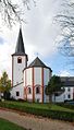
Monastery church in Niederehe

Eifel landscape
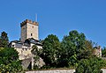
Kerpen Castle

Hillesheim city fortifications


,_Burg,_2011-09_CN-01.jpg)


Rail connection
The only direct rail connection to the cycle path is the Hillesheim-Oberbettingen station on the Eifelbahn between Gerolstein and Trier . From here, Bolsdorf can be reached after two kilometers via the K47 and K55 district roads. Alternatively, Hillesheim can be reached in about three kilometers via the L10 state road.
Connecting cycle paths
Kalkeifel-Radweg and Kosmosradweg as well as the Mineralquellen-Route are important longitudinal and cross connections as well as additions to the Kylltal-Radweg , the Maare-Mosel-Radweg and the Ahr-Radweg . The Kalkeifel cycle path leads north from the Kylltal cycle path to the Ahr cycle path. While the mineral springs route connects the Ahr cycle path with the Maare-Mosel cycle path and the Eifel-Ardennes cycle path . Beyond Daun , the Kosmosradweg as a connection to the Maare-Mosel-Radweg and the Eifel-Ardennen-Radweg extends the cycle path network of the region.
See also:
literature
- ADFC regional map Eifel / Mosel , 1: 75,000. Bielefelder Verlag, 1st edition 2006. ISBN 3-87073-391-8
- Cycle Atlas Cycle Atlas "South Eifel" - between the Ardennes and the Vulkaneifel , 1: 75,000. Esterbauer publishing house. ISBN 978-3-85000-269-1
Web links
- Kalkeifel cycle path map and GPS data, at eifel.info, accessed on August 4, 2018
- Info boards:
- Water & Steam (PDF; 3.9 MB), accessed on August 4, 2018
- Old oceans and fresh water (PDF; 10.6 MB), accessed on August 4, 2018
- Kalkeifel-Radweg: Bolsdorf-Hillesheim - Ahrdorf (Bhf.) 22 km altitude profile, GPS track and pictures, from www.bahntrassenradwege.de, accessed on August 4, 2018
- Des Radlers Glück Important cross and longitudinal connections in the cycle path network of the Eifel , on radwanderland.cms.rdts.de, accessed on August 4, 2018
- Information about the Kalkeifel , at www.naturpark-eifel.de, accessed on August 4, 2018
swell
- Radwanderland.de , accessed November 2011
Coordinates: 50 ° 16 '24.91 " N , 6 ° 39' 24.65" E