Neublankenheim Castle
| Neublankenheim Castle | ||
|---|---|---|
|
Neublankenheim Castle |
||
| Alternative name (s): | Neublankenheim ruins | |
| Creation time : | 13th or 14th century | |
| Castle type : | Hilltop castle | |
| Conservation status: | ruin | |
| Standing position : | Country nobility, high nobility | |
| Construction: | Quarry stone | |
| Place: | Üxheim | |
| Geographical location | 50 ° 21 '26.6 " N , 6 ° 46' 26.6" E | |
| Height: | 355 m above sea level NHN | |
|
|
||
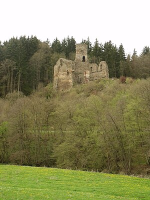
The castle Neublankenheim even ruin Neublankenheim , the ruins of a hilltop castle in the Eifel .
location
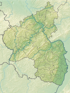
The castle is located in the Kalkeifel , a natural sub-region of the North Eifel between the High Fens and the Vulkaneifel in Rhineland-Palatinate , in the immediate vicinity (about 150 meters away) south of the state border with North Rhine-Westphalia (municipality of Blankenheim ). It is located in the municipality of Üxheim ( Vulkaneifel district ) about 2 kilometers north of the Ahütte district and near the border with the neighboring municipality of Nohn . The system stands on an elevation approx. 355 meters above sea level and thus a good 20 meters above the valley floor of the Ahbach, which runs a few meters further east, near state road 70 .
history
The historical origins of the castle are obscure, which is due, on the one hand, to the fact that no excavations have been carried out so far , and on the other hand, a mix-up with Blankenheim Castle in documents cannot be ruled out. A first mention of this castle in a deed of donation from 1272 is therefore considered controversial. Rather, a document from 1341 is regarded as the oldest source for the castle, in which Margrave Wilhelm I von Jülich transferred "sine nuwe burch Blankenheym" to Gerhard V von Blankenheim as an inheritance . From then on, the castle (mostly as a fief) remains in the possession of the Lords of Blankenheim and is u. a. administered by Friedrich von Blankenheim . In 1470 the county of Blankenheim passed to Count Dietrich III after several changes of ownership and inheritance disputes . from Manderscheid , while the castle was in the meantime transferred to the Lords of Mirbach .
In 1521 Dietrich von Mirbach describes Neublankenheim Castle as "destroyed" and asks his liege lord, Count Johann von Manderscheid, for help with the reconstruction. In the following years the castle was not rebuilt (apparently, no reliable source finds) due to its remote location and the resulting strategic insignificance. Around 1770, Duke Karl Maria Raimund von Arenberg acquired the surrounding lands and the castle ruins, so that the property passed to the Duchy of Arenberg . After the occupation of the left bank of the Rhine by French revolutionary troops in 1794 , the possessions of the Duchy of Arenberg also passed to the French state due to the provisions of the Peace of Lunéville . Neublankenheim Castle was auctioned off and was henceforth privately owned. The current owner is the district of Vulkaneifel (formerly the district of Daun).
description
The remains of the castle that still exist today form a rectangle with a side length of about 40 × 20 meters. This is bordered in the north by a moat that separates the castle square from the rest of the ridge. The surrounding walls on the west, south and east sides are still multi-storey. Apart from the thicker south wall, the masonry has an average thickness of 2 meters. The surrounding walls have several window openings and notches as well as a noticeably large arched opening in the south wall. There are still holes in the bars and remains of the original plaster. In the north rises up a several meters high single wall pillar, which is seen as the remainder of an inner wall.
The most striking part of the ruin is still the about 24 meters towering castle keep on the southwest corner of the complex. The diameter is about 5.5 meters with a wall thickness of 1.5 meters. It has the unusual floor plan of an approximate semicircle, with the side facing the interior of the castle complex forming a straight line. The adjoining southern wall is 3 meters thick, making it the mightiest of the castle.
Current condition
In the years 2004–2006 extensive renovation work took place. The sole aim of these was to secure the existing masonry against further deterioration. So there was no reconstruction.
Neublankenheim Castle is neither inhabited nor managed. As an open ruin, it is freely accessible at all times. Below the castle at Landesstraße 70 is a parking lot for hikers that was created for the renovation work. From here a footpath leads up to the ruin. Marked hiking trails through the Ahbachtal in the immediate vicinity of the ruin include the Geo-Path Hillesheim and the Eifelkrimi-Wanderweg . The castle is the setting for the episode “First Kisses Between Ruins” based on a presentation by Jacques Berndorf . Furthermore, the Kalkeifel Cycle Path and the Mineral Spring Route run as "themed routes" and sections of a supra-regional long - distance cycle path network with a connection to the Ahr Valley Cycle Path , which passes just a few kilometers further north, using sections of the former railway line of the dismantled (upper) Ahr Valley Railway in the section between Ahrhütte and Lissendorf along here.
Monument protection
The ruin is designated as a cultural monument and is therefore a listed building .
legend
The legend of the unhappy love between the young count's daughter and the poor servant is entwined around the castle .
Web links
Individual evidence
- ↑ Neublankenheim castle ruins. TW Gerolsteiner Land Tourismus und Wirtschaftsförderung GmbH, accessed on December 20, 2018 .
- ↑ Neublankenheim castle ruins. In: www.eifel.de. Bauer + Kirch GmbH, accessed December 20, 2018 (commercial).
- ↑ a b c d Josef Dreesen, Manfred Simon: Neublankenheim castle ruins look back and outlook. In: Heimatjahrbuch 1991. Landkreis Vulkaneifel, p. 163 , accessed on December 20, 2018 .
- ↑ a b Bruno Hirschfeld: Castles of the Eifel. In: Eifel-Festschrift for the 25th anniversary of the Eifelverein. Alfred Herrmann self-published by the Eifelverein in commission from Carl Georgi, Bonn, 1913, p. 257 ff. , Accessed on December 20, 2018 (online from dilibri Rheinland-Pfalz).
- ^ Friedrich-Wilhelm Krahe: Castles of the German Middle Ages, floor plan lexicon . Licensed edition for Bechtermünz Verlag published by Weltbild Verlag GmbH, Augsburg 1996, ISBN 3-86047-219-4 , p. 420 .
- ↑ Eifel Krimi hiking trail. Eifel Tourismus (ET) Gesellschaft mbH, accessed on December 20, 2018 .
- ↑ Kalkeifel cycle path. Eifel Tourismus (ET) Gesellschaft mbH, accessed on December 20, 2018 .
- ^ Rhineland-Palatinate cycling region. Rhineland-Palatinate Ministry of Economics, Transport, Agriculture and Viticulture, accessed on December 20, 2018 .
- ↑ General Directorate for Cultural Heritage Rhineland-Palatinate (ed.): Informational directory of cultural monuments - Vulkaneifel district. Mainz 2020, p. 54 (PDF; 4.6 MB).
- ^ Jürgen Mathar: The castle ruins Neublankenheim in Üxheim-Ahütte. In: Heimatjahrbuch 2006. Landkreis Vulkaneifel, p. 14 , accessed on December 20, 2018 .


