
Dreimühlen waterfall
| Dreimühlen waterfall | ||
|---|---|---|
 Dreimühlen waterfall (2016) |
||
| Coordinates | 50 ° 19 '30 " N , 6 ° 46' 8.4" E | |
|
||
| place | Uxheim-Ahütte | |
| height | 6 m | |
| width | 12 m | |
| Falling watercourse | Mühlenbach | |
| Estuarine waters | Ahbach | |

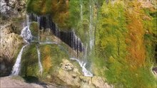
The waterfall Dreimühlen is a waterfall , fed by the mill stream in the district Üxheim -Ahütte. Over a width of about 12 m, the calcareous, cold water falls about 4 to 6 m deep to the Ahbach . The waterfall is located in the triangle of the villages Ahütte , Niederehe and Nohn in the Kalkeifel . It is named after the neighboring Dreimühlen ruin .
In the area of the waterfall, the Ahbach formed the border between the districts of Daun and Adenau until September 30, 1932 and from October 1, 1932 to November 6, 1970 the border between the districts of Daun and Ahrweiler .
Emergence
Three smaller karst springs with heavily calcareous water had created a calcareous sinter plateau about 300 meters wide and 100 meters deep in the past 10,000 years since the last ice age .
During the construction of the Dümpelfeld – Lissendorf railway line , which was opened on July 1, 1912, the source streams were combined to form the Mühlenbach and led under the railway structure. At the point where the artificial stream crosses the step, a ledge has grown over which the water falls into the valley and flows a few meters further into the Ahbach.
The heavy vegetation with deciduous moss , especially Cratoneuron commutatum , together with diatoms accelerates this process, since the surface is enlarged and precipitated lime is bound. This is around 0.5 kg per hour, which results in an annual amount of around 4,500 kg. Due to its constant growth, the moss Cratoneurum commutatum escapes the encrustation with carbonate on its surface; However, in the area where it adheres to the calcareous sinter, it dies off, is encrusted and thus continuously forms new, porous sintered rock, which causes an annual increase of about 10 cm.
The waterfall was declared a natural monument in 1938 .
In 1986 the sintered wall had to be secured against possible slipping by concrete foundations because the sub-surface made of alluvial clay no longer threatened to withstand the weight. The upper part was blown up, creating the heel in the middle.
- Sinter formation Dreimühlen waterfall

The mill stream above the waterfall

Water flows through the moss of the waterfall ...

... and drips to the floor.

The moss Cratoneuron commutatum binds precipitated lime on its surface
_1.JPG)


In January 2014, extensive clearing of trees and low trees was carried out around the waterfall , which makes the waterfall more visible, but bare ground can be seen in many places in the area. After the clearing, a representative of the Vulkaneifel Nature and Geopark expressed the hope that the vegetation would soon recapture these areas.
Cycling, hiking
Hikers reach the waterfall from one of the starting points on the Geo-path or Eifelkrimi -Wanderweg. For cyclists, it can be reached via the Kalkeifel cycle path and the mineral spring route . You can also get there on foot from the Ahütte and Niederehe districts of Üxheim.
See also
Web links
- Dreimühlen waterfall - a whim of nature on "Rhein-Eifel.TV"
- Information board at the waterfall: Dreimühlen waterfall ( Memento from October 8, 2007 in the Internet Archive )
Individual evidence
- ↑ Entry on Dreimühlen waterfall and marble wall in the database of cultural assets in the Trier region ; accessed on February 28, 2016.
- ↑ Felicitas Schulz and Mario Hübner: “In May everything will look completely different again”. In: www.volksfreund.de. January 31, 2014, accessed February 27, 2016 .