
Eifel
| Eifel | |
|---|---|
 Eifel map |
|
| Highest peak | Hohe Acht ( 746.9 m above sea level ) |
| location | Germany ( Rhineland-Palatinate , North Rhine-Westphalia ), Belgium , Luxembourg |
| part of | Rhenish Slate Mountains |
| Coordinates | 50 ° 23 ' N , 6 ° 52' E |
| Type | Low mountain range |
| rock | Slate , limestone , quartzite , sandstone , basalt |
| surface | over 5,300 km² |
 Location of the Eifel in Germany (foothills in Belgium and Luxembourg) |
|
 Morphologically factually connected mountainous region of the Ardennes and Eifel, framed by the rivers Maas, Moselle and Rhine. The highest point is the Hohe Acht at 746.9 m above sea level. NHN |
|
The Eifel is the German part of an up to 746.9 m above sea level. NHN high low mountain range in Rhineland-Palatinate and North Rhine-Westphalia ( Germany ), the continuation of which in Belgium and Luxembourg are the Ardennes . These cross-border mountains are part of the Rhenish Slate Mountains .
geography


location
The Eifel lies between Aachen in the north, Trier in the south and Koblenz in the east. It falls in the northeast along the line Aachen - Düren - Bonn to the Lower Rhine Bay . In the east and south it is bounded by the Rhine and Moselle valleys. To the west it merges in Belgium and Luxembourg into the geologically related Ardennes and the Luxembourg Ösling . It is located in Rhineland-Palatinate and North Rhine-Westphalia and touches the Eupen - Sankt Vith - Luxembourg area. The highest point is the Hohe Acht volcanic cone ( 746.9 m ). Originally the Carolingian Eifelgau only approximated the area around the sources of the rivers Ahr , Kyll , Urft and Erft . The name has recently been carried over to the entire region.
Landforms
The Eifel is one of the parts of the Rhenish Slate Mountains whose undulating plateau is known as the Rump Highlands , which developed from the primeval mountains eroded by erosion during the Variscan orogeny phase and later renewed uplift. In the western part of the plateau, individual mountain ridges up to 700 m high such as the Schneifel and Hohes Venn run through . In the eastern part of the Hohe Eifel and the Vulkaneifel , tertiary and quaternary volcanism resulted in individual cinder volcanoes and basalt peaks such as the Hohe Acht and the Ernstberg , which tower over the hilly landscape.
The rivers such as Our , Kyll , Ahr , Brohlbach and Rur that drain towards the Moselle , Rhine and Maas have cut deeply towards the edge of the Eifel and form larger valleys.
The more than 5,300 km² large Eifel is geographically divided into northern and southern Eifel, but more finely divided into several natural landscapes with some further subdivisions.
National and natural parks
Since 2004, part of the northern Eifel has been designated as the Eifel National Park . Viewed roughly from north to south, there are four nature parks in the Eifel: Rhineland , Hohes Venn-Eifel , Vulkaneifel and Südeifel , with the first-mentioned park only reaching into the northern foothills of the Eifel in the south.
Natural structure
In the handbook of the natural spatial structure of Germany , the German part of the Eifel, which belongs to the Rhenish Slate Mountains, was naturally divided into three main unit groups (two digits) and these further into main units (three digits). These classifications were subsequently refined as follows in the individual sheets Trier / Mettendorf , Cochem (both 1974) and Cologne / Aachen (1978). In a revision from 1992 to 1994, the Federal Agency for Nature Conservation merged the three main unit groups (Eastern Eifel, West Eifel and Vennvorland) under the summarizing group D45, Eifel and Vennvorland . The volcanic dome area around the Laacher See is a special feature. In terms of natural space, it is assigned to main unit 292 Lower Middle Rhine Area and belongs to main unit group 29 Middle Rhine area . According to this classification, it is not part of the Eifel. In general, however, it is undoubtedly part of the Vulkaneifel, which is why the corresponding natural areas are listed here, especially since the Ettringer volcanic peaks assigned to it already have Eifel features in terms of their altitude. In the 1954 edition of the Handbook of Natural Spatial Structure, this volcanic hilltop land , like the wing of the Middle Rhine Bay on the left bank of the Rhine, still formed part of the main unit 273 Rheineifel , which was deleted in the 1960 revision in favor of an expansion of the Middle Rhine area. For each of the finest natural spaces in the landscapes in Rhineland-Palatinate, profiles of the same name were created by the State Information System of the Nature Conservation Administration (LANDIS):
|
|
Further room divisions
In addition to the classification shown in the handbook of the natural spatial structure of Germany, many other subdivisions of the Eifel are known according to a wide variety of criteria, some of which are listed here.
- Hohe Eifel or Hocheifel (central east)
- Vulkaneifel (central south)
- Ahreifel or Ahr Mountains (in the east)
- Rheineifel (in the east)
- Breisiger Ländchen (around Bad Breisig )
-
North Eifel
- Voreifel in the northeast
- Rureifel , often equated with northern Eifel
- Trembling forest
- Huertgenwald
- Aachen hill country
- Northern Kalkeifel
- East and Vordereifel
in the Cochem-Mayen area (east) - Moseleifel (in the southeast)
-
South Eifel near Trier
- Bitburger Gutland
- Kyllburger Waldeifel or just Waldeifel , also Kylleifel
- Westeifel (area around Prüm )
- High Fens (north-west, transition to the Ardennes )
Note: Only natural or cultural landscape Eifel regions were named; some of them overlap. Some of the other terms from tourist and tourism associations are not in a correct geographical context.
Mountains and elevations


.JPG)


Away from the valleys, the Eifel is a gently undulating plateau from which long ridges and individual mountains protrude. Most of these elevations do not reach great heights compared to their surroundings, but some, such as the " Black Man " in the Schnee Eifel , can be seen from afar as elongated, wooded ridges or clearly sloping hill peaks.
The highest mountain in the entire Eifel is the Hohe Acht at 746.9 m . It is the only Eifel elevation over 700 m . However, many peaks, ridges and larger areas such as the Zitterwald reach heights of more than 600 m . Among them are two dozen peaks with a good panoramic view , many of which have a lookout tower . From north to south: Michelsberg, Häuschen and Teufelsley in the north, Adert, Hohe Acht and Raßberg in the northeast, Hochkel, Nerotherkopf, Dietzenley and the ruins of Kasselburg in the central area, Prümer Kalvarienberg, Hart- and Prümer Kopf in the east, Steine- und Mäuseberg near Daun, Hochsimmer and Scheidkopf near Mayen, Eickelslay and Absberg in the southeast, Krautscheid and Hohe Kuppe in the southwest.
Many of these striking points are connected by the Green Road Eifel-Ardennen , which crosses the east and south, the German Volcano Road , the German Wild Road and the Southern Eifel holiday route .
The mountains and elevations of the Eifel listed below are sorted by height in meters (m) above sea level and each assigned to their finest sub- natural area as well as the superordinate (three-digit) main unit (see section Natural structure ):
| Mountain / elevation | Height (in m) |
Finest sub-natural space |
Natural area no. |
Natural spatial main unit |
|---|---|---|---|---|
| High eight | 746.9 | Hohe-Acht-Bergland | 271.20 | Eastern High Eifel |
| Ernstberg (Erresberg) | 699.8 | Prümscheid | 277.20 | Kyllburger Waldeifel |
| nameless hilltop (near Black Man ) |
699.1 | Schneifel move | 281.0 | Western High Eifel |
| Black man | 697.8 | Snow ridge | 281.0 | Western High Eifel |
| Botrange | 694.24 | Venn plateau | 283.0 | High Fens (Belgium) |
| Scharteberg | 691.4 | Prümscheid | 277.20 | Kyllburger Waldeifel |
| White stone | 690 | Monschau-Hellenthaler forest plateau | 282.4 | Rureifel |
| Prümscheid | 682 | Prümscheid | 277.20 | Kyllburger Waldeifel |
| Castle hill of the Nürburg | 676.5 | Hohe-Acht-Bergland | 271.20 | Eastern High Eifel |
| Hochkelberg | 674.9 | Trierbach-Lieser-Quellbergland | 271.40 | Eastern High Eifel |
| Steling | 658.3 | Venn plateau | 283.0 | High Fens (Belgium) |
| Dohmberg | 653.2 | Dockweiler Vulkaneifel | 276.81 | Kalkeifel |
| Nerother head | 651.7 | Daun-Manderscheider volcanic mountains | 270.50 | Moselle Eifel |
| nameless hilltop (near Gondelsheim ) |
651.3 | Duppach back | 281.4 | Western High Eifel |
| Radersberg | 637 | Dockweiler Vulkaneifel | 276.81 | Kalkeifel |
| Aperture | 631.3 | Kyll-Vulkaneifel | 276.80 | Kalkeifel |
| Aremberg | 623.8 | Northern Ahrbergland | 272.1 | Ahreifel |
| nameless summit (near Schöneseiffen ) |
622.7 | Dreiborn plateau | 282.5 | Rureifel |
| Dietzenley | 617.6 | Prümscheid | 277.20 | Kyllburger Waldeifel |
| Hardtkopf | 601.5 | Southern Schneifel foreland | 280.4 | Islek and Ösling |
| Heathen heads | 595 | Eichholz back | 276.3 | Kalkeifel |
| High simmer | 587.9 | Nitz-Nette forest | 271.21 | Eastern High Eifel |
| Michelsberg | 586.1 | Northern Ahrbergland | 272.1 | Ahreifel |
| Long lap | 583.5 | Lammersdorfer Venn plateau | 283.0 | High Fens |
| Goose neck | 575.3 | Kempenich tuff plateau | 271.1 | Eastern High Eifel |
| Eiart | 565.5 | Dreiborn plateau | 282.5 | Rureifel |
| Hochstein | 563.0 | Ettringer volcanic peaks | 292.01 | Lower Middle Rhine Region |
| Mäuseberg | 561.2 | Daun maar area | 270.51 | Moselle Eifel |
| Stromberg | 558.2 | Eichholz back | 276.3 | Kalkeifel |
| Rockeskyller head | 554.6 | Dockweiler Vulkaneifel | 276.81 | Kalkeifel |
| High cunning | 549.1 | Daun maar area | 270.51 | Moselle Eifel |
| Roßbüsch | 538.6 | Kyll-Vulkaneifel | 276.80 | Kalkeifel |
| Cow thorn | 532.1 | Kyll-Vulkaneifel | 276.80 | Kalkeifel |
| Burberg | 528.5 | Salmer hill country | 277.3 | Kyllburger Waldeifel |
| nameless hilltop (near Wolfgarten ) |
527.8 | Kermeter forest | 282.8 | Rureifel |
| Game Hill | 525.3 | Kermeter forest | 282.8 | Rureifel |
| Calvary | 522.8 | Dollendorfer Kalkmulde | 276.5 | Kalkeifel |
| Burned mountain | 516.2 | Kermeter forest | 282.8 | Rureifel |
| Red hedge | 510.5 | Kyll-Vulkaneifel | 276.80 | Kalkeifel |
| Little house | 506.5 | Southern Ahrbergland | 272.3 | Ahreifel |
| Towering high | 499.9 | Northern Ahrbergland | 272.1 | Ahreifel |
| Teufelsley | 495.9 | Southern Ahrbergland | 272.3 | Ahreifel |
| Krufter furnace | 463.1 | Laacher Kuppenland | 292.0 | Lower Middle Rhine Region |
| Kellerberg | 448.8 | Naurather Horst | 270.60 | Moselle Eifel |
| Herkelstein | 434.5 | Mechernich mountain and hill country | 275.2 | Mechernicher Voreifel |
| nameless hilltop (near Osann-Monzel ) |
434.1 | Moselle Mountains | 250.2 | Moselle valley |
| Stagnates | 433.9 | Mechernich mountain and hill country | 275.2 | Mechernicher Voreifel |
| Vitus head | 428.1 | Laacher Kuppenland | 292.0 | Lower Middle Rhine Region |
| Monzeler Hüttenkopf | 423.4 | Moselle Mountains | 250.2 | Moselle valley |
| Castle Hill | 400.8 | Hürtgen plateau | 282.1 | Rureifel |
| Sonnenberg | 393.3 | Kermeter forest | 282.8 | Rureifel |
| Calmont | 378.4 | Gevenich plateau | 270.02 | Moselle Eifel |
| Bausenberg | 339.8 | Königsfelder Eifelrand | 274.3 | Münstereifel forest and northeastern Eifel foot |
| Land crown | 271.7 | Upper winter terrace and hill country | 292.23 | Lower Middle Rhine Region |
Waters


The Eifel is criss-crossed by numerous streams and smaller rivers due to the mild, humid Atlantic climate. Especially in the northern Eifel z. Sometimes very large reservoirs , such as the Rursee , the second largest reservoir in terms of volume in Germany, and the Urftsee .
The natural lakes of volcanic origin are a special feature of the Eifel. The largest, the Laacher See, is a collapsed, water-filled caldera ; the maars are water-filled volcanic eruptions. The largest maar lake is the powder maar . The even larger basin, the Meerfelder Maar , has silted up to three quarters.
Rivers and streams
The numerous rivers and brooks of the Eifel drain it through the large rivers Rhine (with its tributary Moselle ) and Maas (with its tributaries Rur and Ourthe ) flowing outside the Eifel to the North Sea. The rivers and their largest tributaries that run within the mountains include:
|
Rhine tributaries: |
Maas tributaries: |
Lakes and reservoirs
|
Reservoirs
|
Volcanic lakes |
 Dams in the Eifel that drain into the Rur |
geology
Despite the interesting geology of the Eifel region, only three comprehensive descriptions of the geology were made. In 1822 Johann Steiniger published the first geological map of the area and in 1853 the geognostic description of the Eifel . In 1915 Otto Follmann published a new description of the state of knowledge at the time with the outline of the geology of the Eifel . Finally, in 1986 published Wilhelm Meyer with the geology of the Eifel , which now applies the band in the fourth revised edition of the standard work as the geology of the Eifel.
The Eifel is a largely 400 million year old, Variscan remnant of a rump mountain range and geologically part of the slate mountain range on the left bank of the Rhine . In the area of the Stavelot-Venn-Saddle ( Hohes Venn ) the oldest rock layers can be found, which originate from the Cambrian and are around 550 million years old. The Eifel is one of the few volcanically active areas in Germany, as evidenced by numerous carbon dioxide emissions, for example in the Laacher See . The last eruptions that created the youngest maars were around 11,000 years ago.


Basement
The basement is in the Eifel as in the other regions of the Rhenish Massif mainly of shale , limestone , quartzite and sandstone from the time of Devon . Only on the northern edge of the Eifel do older rocks from the Cambrian and Ordovician bite in the High Fens and its surroundings . Rocks from the carboniferous following the Devonian do not occur in the Eifel itself, but adjoin its northern edge in the area of Aachen .
The Devonian rocks were deposited in a sea basin into which the rubble of the large northern continent Laurussia (Ur-North America + Ur-Europe) formed in the course of the Caledonian mountain formation in the Silurian mountains was washed in from the north. From the end of the Lower Carboniferous the sea basin was seized by the Variscan mountain formation, pushed together and lifted out, and thus formed part of the Variscan high mountains that spanned large parts of Europe in the Upper Carboniferous and in the early Permian.
Overburden
Since this fold, the Eifel has essentially remained mainland. During the Permian , after the uplift ended, the Variscan mountains were largely eroded, so that only a relatively flat mountain hull was left. Only for a short time and only partially this was later flooded by the sea.
Deposits from the Triassic and Jurassic periods are preserved in the so-called Eifel north-south zone. This is a subsidence zone that extends from Trier Bay in the south to the Lower Rhine Bay in the north. Through this zone there was at times a sea connection between northern and southern Central Europe. Remnants of the sediments deposited at this time have been preserved in greater distribution in the Maubach- Mechernicher Triassic Triangle in the north and in the Oberbettinger Triassic Trench in the area around Hillesheim and Oberbettingen .
In the Upper Cretaceous and the Tertiary , the Eifel was mainly flooded from the north. Remnants of Cretaceous rocks were discovered on the High Fens. Scattered patches of Oligocene deposits can be found there and in the West Eifel.
From the Pliocene , the Rhenish Slate Mountains, and with it the Eifel, experienced an uplift. This ascent led to the fact that the streams and rivers cut their way into the flat undulating landscape and the current face of the low mountain range with flat plateaus and deeply cut valleys was formed.
Due to numerous recent research results, the climate changes in the Eifel since the last Ice Age can be traced in detail.
Volcanism


The volcanism of the Eifel began 50 million years ago and has continued into the geological present. He created numerous landscape-defining volcanic structures, lava flows and extensive ceilings of volcanic ejecta made of tuff and pumice , which have formed the basis of significant mining activities for the extraction of building materials since Roman times.
The first volcanic eruptions took place in the early Tertiary , mainly in the Hocheifel, before the volcanic activity in the Siebengebirge and Westerwald . The Hocheifel volcanism died out at about the same time as that of the Siebengebirge about 15 to 20 million years ago.
In contrast to that of the Hocheifel, the volcanism of the West and East Eifel is much younger than that of the Siebengebirge and Westerwald. It began in the West Eifel in the area of Daun, Hillesheim and Gerolstein about 700,000 years ago and created a chain of ash volcanoes, cinder cones , maars and craters running from northwest to southeast . The youngest maars are only a little older than 11,000 years.
In the Eastern Eifel, volcanism began around 500,000 years ago in the area of today's Laacher See and expanded south to the Neuwied Basin, and to the east it crossed the Rhine. The amount of basalt lavas , pumice and ash tuffs produced by the volcanoes was far greater here than in the West Eifel. The Eastern Eifel volcanism came to a preliminary end with a massive volcanic eruption, as a result of which the magma chamber emptied and collapsed, creating a caldera . Today's Laacher See was then formed in the caldera . The ashes of the eruption can now be detected as a thin layer in deposits throughout Central Europe and as far as Bornholm .
The cause of Eifel volcanism is magma that either rises from the upper areas of the earth's mantle directly to the surface of the earth or collects in a magma chamber that is still several tens of kilometers deep at the base of the earth's crust , from which magma penetrates upwards at irregular intervals and volcanic eruptions caused.
So until about 11,000 years ago there was strong volcanic activity in the Eifel, which the people living here also experienced. From a geological point of view, the Eifel is still considered volcanically active today. Characteristics of this ongoing volcanic activity are, among other things, escaping gases, for example carbon dioxide (CO 2 ) escapes in the Laacher See .
climate
The Eifel lies in the zone of the Atlantic maritime climate with relatively high amounts of precipitation . The winters are moderately cold, extensive and sometimes snowy, the summers are often humid and cool. The prevailing wind direction is west / south-west. Relatively dry and mild climate prevails in the wind and rain shadow of the Hocheifel. Siberian cold air has little effect on the weather in the higher elevations of the Eifel, as the proximity to the Atlantic means that milder sea air is brought to the Eifel even in winter.
The long-term average in winter is the snow frequency in the high areas with a total of 70 days of closed snow cover (in comparison: Bitburg 35 days, Maifeld 30 days), but it fluctuates from year to year. But even in the Schnee Eifel there is only a cover of snow on nine consecutive days, as there are no longer uninterrupted cold spells. The snow depths vary between 15 cm and 60 cm on average. Due to the Eifel's location in the area of influence of the damp Atlantic climate, extreme snow depths can be reached in individual years (March 2, 1987: measured snow cover in the Eifel 227 cm on the White Stone ).
The mean temperature in the coldest month (January) is −1.5 ° C in the high areas and +1.5 to 2 ° C in the foothills. Frost days (i.e. days with minimum temperatures below 0 ° C) are up to 110 per year at high altitudes. The number of ice days (ie days with maximum temperatures below 0 ° C) is a long-term average of 30 to 40. The warmest month (July) has an average temperature of only 14 ° C in the high areas (for comparison: it is throughout Germany 17.1 ° C). The mean annual rainfall decreases significantly from west to east due to the leeward effect of the high altitudes: while in the Schneifel there is still an average of 1200 mm ( Hohes Venn 1400 mm – 1500 mm) rainfall, the rainfall in the Maifeld is only 600 mm.
The bioclimatic conditions are favorable in the Eifel. Heat stress and humid air rarely occur in summer. Overall, the Eifel has a decidedly stimulating climate , whereby the high altitudes are considered to be very stimulating . The Eifel is a clean air area with very little air-chemical pollution. On hot sunny days there is sometimes an increased concentration of ground-level ozone.
Flora and fauna

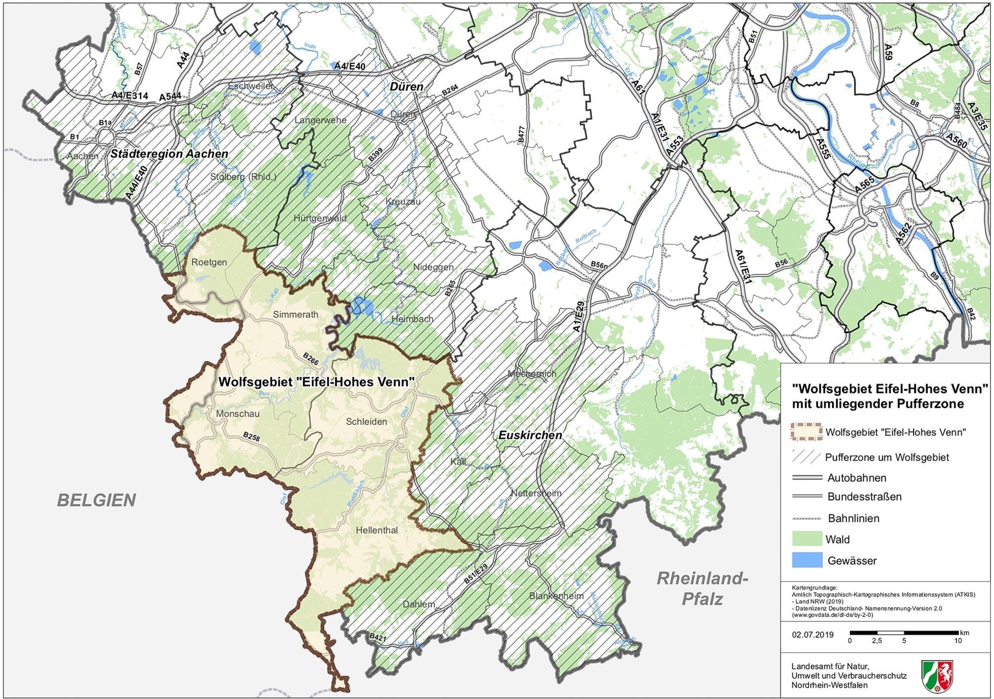
Since July 2019, the Eifel around Monschau has been the third region in North Rhine-Westphalia in which a wolf has settled. The “Eifel / Hohes Venn” wolf area designated by the NRW Ministry of the Environment is 505 square kilometers and is located in the Monschau, Hellenthal, Schleiden, Simmerath and Roetgen area.
history
.jpg)
etymology
Use of language throughout history
At the time of the Roman Empire , the entire mountain range between the Rhine, Meuse and Moselle was called Arduenna silva ("high forest"). The oldest evidence of the name "Eifel" dates back to the early Middle Ages : after the collapse of the Western Roman Empire , the Franconian Empire existed in what is now France and western Germany . This was divided into Gaue (lat .: pagi ), with one of these Gaue, the Eifelgau , extending over the headwaters of Erft , Urft , Kyll and Ahr , i.e. mainly over the northern and northwestern foothills of today's Eifel in the eastern half of the Arduenna silva the Romans. West of the Eifelgau was the Ardennengau , whose name was derived from the Arduenna silva .
After the end of the Franconian Empire, the names of the two old districts remained in use. Over the centuries, an ever larger area was called the "Eifel". Today the entire German-speaking part of the mountain range between the Rhine, Meuse and Moselle is called the "Eifel" (including some areas outside Germany, see → Belgian Eifel ), while the French-speaking part in Belgium and France is called the "Ardennes".
Earliest surviving evidence
In the year 762 Eifflensis pagus , 772 Eiffelnsis pagus , 804 in pago aquilinse , 838 Eifla , 845 Eiflensis pagus , 855 Eiflinsis pagus , 860-886 Agflinse , 975 pagus Aiflensis , 1051 Eiffila , 1105 Eifla , 1121 Eifla
Attempts at interpretation
Müller / Schnetz (1937) see the dropout of an -n- between the diphthong and the syllable -fel . The resulting basic shape, Anfil or Anfali , then meant “not quite as flat surface”. An - then be a prefix and -fali , which is related to the Slavic Polje ("field"), means "plain, heather".
W. Kaspers (1938) deduces the basic form aku-ella, akwella from the traditional form in pago aquilinse and shows the development towards the Eifel in the series: aquila > agfla > aifla > eifla > Eifel . Akuella originates from the pre-German and means "land with peaks, peaks".
Both approaches, like some others, are very controversial. Heinrich Dittmaier's approach (1961) is considered the most convincing suggestion . Dittmaier initially assumes a Germanic Ai-fil . The second part of the name corresponds to Ville , which today denotes a mountain range between Erft, Swist and Rhine. The sound forms Vele , Vile and Many can be found in field names such as Veler Weg or Velerpfad . In contrast to the current name Ville , the fricative in the Eifel is pronounced harshly. Responsible for this was probably a sound between ai and -fil that to the f was assimilated, possibly f, k, ch, d, t . Dittmaier defines a k or ch as the missing sound , which is why Eifel originally goes back to Aik-fil . Aik / Aich is the tree name oak and differentiates the meaning of the basic word Ville . On the basis of the feature "overgrown with oaks", the Eifel (= Eich - Ville ) could be distinguished from the other, still called Ville an der Erft today. However, the original, historical and current vegetation of today's Ville is also characterized by mixed oak forests.
The meaning of "Ville" is also controversial. Dittmaier gives three possible explanations: "swamp area", "plain, heath" and "heath nature", all of which could be reconciled with geology and vegetation.
Another approach is of even older origin and could be of Celtic origin. An altar was found near Cologne, dedicated to the Matronae Aufaniae , Celtic mother goddesses who were worshiped by flowing water. The thesis that the name found its way out of this origin is not compelling, but quite convincing; Eifel would therefore mean water country or water-rich mountains .
Settlement history

Already during the Paleolithic the Eifel was populated by humans - Neanderthals and modern humans . This is exemplified by the Buchenlochhöhle and Magdalenahöhle sites near Gerolstein . The artifacts from the Magdalena Cave also show that the Eifel was visited by people even during the maximum of the last glacial period .
Excavations show that iron was processed in the Eifel as early as the Iron Age. The first smelting plant north of the Alps was built in the Latène period in the 5th century BC in Hillesheim ; There is an iron smelter near Bitburg , in which the metal was melted and processed in an almost industrial way in Roman times. In Roman times, the Eifel was an important economic area. The mineral resources (lead, calamine , iron, lime and stones for building) were mined and trade profited from the Roman highways , such as the Roman road Trier-Cologne , which crossed the Eifel.
In the late Middle Ages, the Eifel was the border area between the archbishopric of Kurköln and Kurtrier , the county of Luxembourg and the Duchy of Jülich . This explains the large number of castles now in ruins, which were built primarily to secure borders. Some smaller principalities and abbeys were able to acquire their independence through skilful politics, for example the Manderscheid-Blankenheim house, the Salm-Reifferscheid county or the Prüm Abbey .
The mining and smelting works with their need for pit wood and charcoal for smelting , the great need for construction and firewood and the shipbuilding industry , which was widespread until the 19th century, led to an almost complete deforestation of the forests in the 17th and 18th centuries. You have to imagine the Eifel around 1800 as a meadow and heathland landscape on which herds of sheep grazed. At the same time the population became increasingly impoverished, as the barren arable land did not allow for rich harvests. With the decline of mining and smelting operations after the middle of the 19th century, the situation of the population did not improve. In addition, the Eifel was a marching area for French troops to all possible theaters of war. These demanded " forage money " from the local population , which contributed to further impoverishment, as the Kottenheim listing shows.
With the beginning of Prussian rule in 1815, little changed in terms of social conditions: The Eifel as the poor fringes of the empire (“Prussian Siberia”) was only of interest for military reasons. For Prussian officials and officers, predominantly Protestants, the transfer to the purely Catholic Eifel was equivalent to a punitive transfer. However, the landscape changed because the Prussians carried out a planned reforestation, albeit with conifers that were not typical of the location.
In the 19th century there were repeated severe famines in the Eifel, especially in 1816/17, 1847 and 1879/80. In a memorandum from 1853 it said: “Very many Eifel residents know no other food than potatoes and bread, which consists of a mixture of oatmeal and potatoes. One can say without exaggeration that two thirds of the entire population eat meat only once a year. ”The consequences of the terrible food situation were all too obvious:“ In 1852, only 10% of all those required to be presented were usable for military service. ”
Because of the poor soil and the harsh climate, which repeatedly led to bad harvests, many farmers were in debt. After reports about the hunger winter of 1879/80, however, there was a wave of solidarity in the empire , and in 1883 the "Eifel Fund" was set up, through which 5.5 million marks for amelioration , afforestation of wasteland and the implementation of mergers were applied.

For a long time, the poor condition of the roads and roads was a hindrance to economic development. Because of the border location between the German Empire, Belgium and Luxembourg (as a transit country to France), many railway lines have been built since the establishment of the empire , which primarily served military-strategic purposes . This improvement in traffic routes also gave tourism a boost. The construction of the Nürburgring in the 1920s also served to promote economic development .
The border region of the Eifel was not spared from the Second World War either. The construction of the western wall was followed by heavy fighting and the Ardennes offensive from September 1944 to January 1945 , especially in the northern Eifel. The remains of the war can still be found there: ruins of former bunkers and parts of anti-tank barriers. Especially in the Hürtgenwald , where the battle with the most losses in the west took place, military cemeteries - such as in Vossenack - bear witness to the brutal events of the war.
economy
Large parts of the Eifel are considered structurally weak areas. There are almost no large industrial settlements. Only in the Pellenz in the Neuwied basin is there a stronger industrialization. Agriculture is practiced in certain valleys and in the lower areas (especially in parts of the Southern Eifel as well as in the Voreifel and the Maifeld). A large number of the farms have switched to horse boarding, some of which offer overnight accommodation for trail riders including horse provision as trail riding stations.
On the Rhine, Moselle and Ahr as well as in the Wittlich valley there is extensive wine business. Tobacco is also grown in the Wittlich Valley . At Holsthum in the Prümtal, in the slipstream of the Ferschweiler plateau , hops are grown for the Bitburger brewery . In the high areas of the Eifel, however, only forestry and dairy farming are possible.
Mining is still practiced in the Eifel today. In Mayen is the company Rathscheck Schiefer in the Moselschiefer mines Katzenberg and Margareta roofing slate mined in Ralingen at the Sauer near the border with Luxembourg on the pit angels in Peter tunnels plaster . In the southern Eifel, especially in the Wehrer Kessel , volcanic carbon dioxide is extracted.
The mining of pumice , basalt and other rocks and minerals has a long tradition in the Eifel . For example, between Daun, Gerolstein and Hillesheim - in the heart of the Vulkaneifel - there are 17 active pits on an area of 11 by 12 km. Residents and affected local authorities have practically no action against the planned (as of July 2012) expansion because it is based on the old mining law .
There is evidence that iron was processed in the Eifel as early as the Iron Age . The first smelting plant north of the Alps was built in the Latène period in the 5th century BC in Hillesheim ; There is an iron smelter near Bitburg , in which the metal was melted and processed in an almost industrial way in Roman times . The Eifel was an important economic area as early as Roman times. The mineral resources ( lead , calamine , iron, lime and stones for building) were mined and trade profited from the Roman highways , such as the Roman road Trier-Cologne , which crossed the Eifel.
The abundance of wood , which was needed for smelting, and of watercourses, which were essential for the preparation and operation of hammer mills and bellows , made it possible for the Eifel to represent an important supra-regional economic area even in the late Middle Ages. About 10% of the iron produced in Europe at that time came from the Eifel. It was traded on the markets of Trier and Cologne .
The water of the Eifel was already of economic importance in Roman times , when the Colonia Claudia Ara Agrippinensium (Cologne) was supplied via the Eifel aqueduct . It was one of the longest aqueducts in the Roman Empire. Today, numerous reservoirs are used to supply water. Also known are the many mineral springs in the Eifel, which often occur here due to the volcanic past. The largest bottlers are Gerolsteiner Brunnen and Apollinaris . One of the largest German breweries, the Bitburger Brewery , has its headquarters and production facilities in Bitburg in the Eifel.
The economic importance of tourism has increased since the Second World War; it was further strengthened , for example, by the national park designation ( Eifel National Park from January 1, 2004) and natural history infrastructure in the Vulkaneifel. Furthermore, the Eifelpark and some maars and lakes are popular excursion destinations. In winter there are offers for winter sports enthusiasts in some high areas, e.g. B. Schwarzer Mann near Prüm , Weißer Stein near Hellenthal or in Rohren near Monschau . Popular destinations for motor sports fans are the Nürburgring with the Nordschleife , the Circuit de Spa-Francorchamps in the Belgian part, or traditionally on Whit Monday discharged Wolsfelder AvD hillclimb . As a tourist and geologically interesting destinations are German Vulkanstraße known that the volcanism of the Eifel dedicated volcano park connects the fossil-rich Kalkmulden the Eifel and many beautiful mountains and some scenic routes . Hiking tourism is also of major economic importance, which is reflected, among other things, in the increasing number of overnight stays by hiking guests and a progressive expansion of the network of trails. In addition to the Eifelsteig , which opened in 2009 and runs across the Eifel from Aachen to Trier , there is a wide network of themed and circular routes.
Culture
literature
As a traditionally secluded landscape in which the population maintains a quiet and simple way of life, the Eifel offered good ground for lively folk poetry. In sagas , legends and fairy tales that were told on long winter evenings in the farmhouse parlors, the longing for a better world that stood in contrast to the reality of life found is often reflected. The Eifel also offered material for numerous literary and cultural works - from and about the Eifel.
Folk literature
Eifel mentality and humor were reflected in numerous purrs and wavers . Käuze and Eifel originals have remained alive in these stories. The "Dahnener Sprünge" have become known beyond the region. Joy in jokes and neighborhood ridicule may have been the motives for these popular Eifel bourgeois stories. Not to be forgotten are the countless horror stories of witches , the undead , headless riders , revenants and werewolves , who - similar to the neighboring Ardennes region - survived into the 20th century.
The folk poetry of the Eifel was collected early on. Inspired by Romanticism , in which folk folklore was seen as a source of unadulterated motifs and shapes, collections of legends and adaptations of Eifel legends were created. One of the revealing collections is the poetic guide through the Eifel by chaplain Johann Heydinger. Prominent authors such as Adelbert von Chamisso , Guido Görres , Karl Simrock , Ernst Moritz Arndt and Friedrich Schlegel stand here alongside early Eifel authors.
The scientific interest in folk culture in the 1920s also gave impetus for collecting folk poetry. The most prominent collector was the Zendscheid-born Bonn professor of folklore Matthias Zender, who as a student between 1929 and 1936 collected around 10,000 legends, folk tales and sagas from the Eifel- Ardennes region, of which 2000 were published.
Horror stories from the Eifel were collected around 1900 by the school director Heinrich Hoffmann from Düren and in the 1930s also by Zender and partially published. In 2003, Peter Kremer published an annotated collection of such legends in a publishing house in Düren.
Authors and works
Well-known historical works of the Eifel are the “Eiflia illustrata or geographical and historical description of the Eifel” by Johann Friedrich Schannat , published in the 17th century, translated, supplemented and reissued in 1824 by Georg Bärsch and the “Eiflia sacra”, also edited by Schannat and reissued in 1888 by Carl Schorn.
Peter Zirbes , a wandering earthenware dealer from Niederkail, is considered the Eifel's first poet . He is the creator of simple dialect poems, which he published in 1852. Ute Bales wrote a novel about his life in 2010, which was awarded the special prize of the jury in the competition for the Book of the Year Rhineland-Palatinate . Many contemporary poets who live in the Eifel or come from the Eifel have processed the Eifel poetically and made it known to readers of poetry in the German-speaking area beyond its borders. These are, for example, Jochen Arlt (who has also made a name for himself as the editor of several Eifel anthologies on this low mountain range), Theo Breuer , Ursula Krechel and Norbert Scheuer . Jochen Arlt's poem “Shopping in Münstereifel” is in the most important German-language poetry collection “ The Great Conrady . The book of German poems. From the beginnings to the present ”.
A great narrator who chose the Eifel as the setting for novels and stories was Clara Viebig , who was born in Trier . The successful author of late naturalism created literary monuments in the Eifel with the novels “Kreuz im Venn” and “Weiberdorf”. The reception of Clara Viebig's work suffered a break because of her marriage to a Jewish publisher during the National Socialist era . Since the end of the 1980s, the writer's works have experienced their deserved renaissance - also in the Eifel. Perhaps the most important literary examination of the Eifel region and its people is the novel "Winterspelt" by Alfred Andersch , which was set in the final phase of the Second World War and depicts the trench warfare during the Ardennes offensive and the tragic connection between people and their fates in an epic manner. The 2005 deceased Heinz Küpper (among other things with the novels "Where to put the head" and "duel with deer"), which in Kall living Norbert Scheuer and from Gerolstein native Ute Bales must be considered the essential Eifel representatives of contemporary German prose today. In their works, they also represent the Eifel symbolically as a rugged landscape that is a reflection of spiritual landscapes. Particularly interesting here (compared to the perspective of the more down-to-earth narrator) is the literary design of the Eifel from the perspective of the outsider. Above all, where no romantic transfiguration of the Eifel is attempted, but where hopelessness and despair in the face of poverty and need, intellectual narrowness or rigid value systems become visible, this literature challenges the exploration of the space and its people. Although Norbert Scheuer was born in the Eifel, the narrators of his novels and stories take the perspective of the distant and outsider. In his most recent volume of short stories, “Kall, Eifel” (2005), Norbert Scheuer succeeded in depicting life in the Eifel in a multifaceted way and making it interesting for readers throughout the German-speaking region. In Ute Bales' novels, too, landscape and people are inextricably linked. The characteristic of the Eifel landscape and its inhabitants is the starting point of a narrative style that shows people as "lonely, lost, in a misunderstood space" in and with their suffering. B. in the novel Kamillenblumen (2010) about the peddler Traud from Kolverath .
Eifel crime novels
A literary genre that has flourished in many regions and major cities in Germany over the past few decades is the detective novel with a local or regional reference. With his crime novels, such as Eifel-Blues (1989), Eifel-Sturm (1999) or Eifel-Träume (2004), Jacques Berndorf has written himself as the German crime writer with the highest circulation. In 1996 he received the main prize of the Eifel Literature Festival. Next to him, Ralf Kramp was awarded the sponsorship award. Ralf Kramp was the first author who, with his series on the "black clover leaf", brought the Eifel as a crime scene to children. Harald Schneider (* 1962) is the author of the Eifel-based children's crime series Die Meisterschnüffler , an interactive reading offer that takes readers from the age of 8 to different locations in the Eifel. Carola Clasen , Carsten Sebastian Henn , Andreas Izquierdo , Rudolf Jagusch , Martina Kempff , Elke Pistor , Edgar Noske and Hans Jürgen Sittig are among the other authors who have dedicated themselves to the “Eifel crime thriller” genre. Günter Krieger and Petra Schier write historical Eifel crime stories . Josef Zierden has published an Eifel crime guide that leads to crime scenes in the Eifel. In the town of Hillesheim there is an Eifel crime thriller trail that leads to the locations of the novels by Jacques Berndorf and Ralf Kramp. The Kriminalhaus in Hillesheim houses the largest crime book collection in the German-speaking world with a stock of 30,000 books, and there is also a “Krimicafé” in the house.
Visual arts
The Eifel was a destination for German Impressionists , including Eugen Bracht , who painted there with colleagues, and August von Brandis , who often stayed there for several days with architecture students from Aachen to familiarize them with landscape painting. Two paintings of the Manderscheider castles have come down to us from Bracht .
Cities

- Cities in the Eifel: Adenau , Bad Münstereifel , Bad Neuenahr-Ahrweiler , Bitburg , Daun , Eupen (Belgium), Gerolstein , Heimbach , Hillesheim , Kaisersesch , Kyllburg , Malmedy (Belgium), Manderscheid , Mayen , Mechernich , Mendig , Monschau , Münstermaifeld , Neuerburg , Nideggen , Polch , Prüm , Schleiden , St. Vith (Belgium), Speicher , Stolberg , Ulmen , Wittlich .
- Larger cities near the Eifel: Aachen , Bonn , Düren , Euskirchen , Koblenz , Liège (Belgium), Luxemburg (Luxembourg), Maastricht ( Netherlands ), Trier .
traffic

Lead through the Eifel:
- the Ahr Valley Railway Remagen – Ahrbrück
- the Eifel line Cologne – Euskirchen – Kall – Gerolstein – Trier with several branch lines. However, a large proportion of the branch lines have now been shut down and partially dismantled.
- the Erfttalbahn Euskirchen – Bad Münstereifel with a connection to the Voreifelbahn Euskirchen – Bonn
- the Eifelquerbahn Andernach – Mayen – Kaisersesch – Daun – Gerolstein. The Kaisersesch – Gerolstein section is currently not in operation. The Kaisersesch-Andernach section of the route is served by Deutsche Bahn as part of the Lahn-Eifel-Bahn. The branch lines branching off Mayen – Polch – Koblenz, Polch – Münstermaifeld and Daun – Wittlich have been discontinued and some sections have been converted for tourist purposes (cycle path).
- the Rurtalbahn Düren – Heimbach. It is also used on summer weekends by the Euregiobahn on the Heerlen (Netherlands) –Aachen – Düren – Heimbach route and is particularly popular with day-trippers, for whom the town of Heimbach and its districts are an attractive destination.
- the Brohltalbahn Brohl – Engeln; a privately operated narrow-gauge railway.
- the A 1 (also Eifelautobahn ), A 48 , A 60 , A 61 , A 64 , A 565 , A 571 and A 573 motorways .
- numerous federal highways , e.g. B. B 49 , B 50 , B 51 , B 52 , B 53 , B 56 , B 257 , B 258 , B 265 , B 399 , B 409 , B 410 , B 418 , B 421 , B 477
See also
- Eifelium
- Eifel Association
- List of mountains and elevations in the Eifel
- List of castles, fortifications and palaces in the Eifel
- List of mines in the Eifel
literature
- Ekkehard Mai (Ed.): The Eifel in the picture. Düsseldorf School of Painting. Michael Imhof Verlag, Petersberg 2016, ISBN 978-3-7319-0356-7 .
- Hans-Ulrich Schmincke : Volcanoes of the Eifel: Structure, origin and today's importance. 2nd, expanded and revised edition. Springer Spectrum, 2014, ISBN 978-3-8274-2984-1 .
- Joachim Schröder: A visit to the early Eifel village. Regionalia Verlag, Rheinbach 2014, ISBN 978-3-95540-114-6 .
- Michael Losse : Castles and palaces in the Eifel. Rheinbach 2013, ISBN 978-3-939722-44-1 .
- Angela Pfotenhauer, Elmar Lixenfeld: Eifel. Monumente edition, German Foundation for Monument Protection, Bonn 2013, ISBN 978-3-86795-068-8 .
- Alois Döhring (Ed.): The Eifel in early photographs . Euskirchen 2011, ISBN 978-3-939722-37-3 .
- Heinz Renn: The Eifel. The walk through 2000 years of history, economy and culture. 4th, unchanged edition. Ed. Eifelverein, Düren 2006, ISBN 3-921805-23-6 .
- Werner D'hein : Nature and culture guide Vulkanland Eifel. With 26 stations on the "German Volcano Road". Gaasterland Verlag, Düsseldorf 2006, ISBN 3-935873-15-8 .
- Walter Pippke, Ida Leinberger: The Eifel. History and culture of the old volcanic region between Aachen and Trier. 5th updated edition. DuMont Reise Verlag, Ostfildern 2006, ISBN 3-7701-3926-7 .
- Eifelverein (Ed.): Eifelführer . Düren 2006, ISBN 3-921805-39-2 ( dilibri.de [accessed on August 7, 2017]).
- Andreas Stieglitz, Ingrid Retterath: Polyglott on tour: Eifel. Munich 2006, ISBN 3-493-56629-8 .
- Hans Joachim Bodenbach: A Hessian watermill in the Eifel? Comments on an Eifel book. A gloss in: Monument Preservation & Cultural History, State Office for Monument Preservation Hesse 1/2000, Wiesbaden 2000, pp. 62–64, 5 figs. (2 of them in color)
- Conrad-Peter Joist (ed.): Landscape painter of the Eifel in the 20th century. Düren 1997, ISBN 3-921805-12-0 .
- Wilhelm Meyer: Geology of the Eifel . Schweizerbart'sche Verlagbuchhandlung, Stuttgart 1986, ISBN 3-510-65127-8 .
- Hans Joachim Bodenbach: Mills of the Eifel comments on an Eifel book. In: New Trierisches Jahrbuch 1990. 38th volume (49th volume of old series). Published by Verein Trierisch im Selbstverlag, Trier 1998, pp. 251–261, with 5 illustrations [This is a critical study of the mill picture on the cover of the book: Erich Mertes: Geschichte-Technik-Untergang. (= Mills of the Eifel. Volume 1). 2., ext. Edition. Helios-Verlag, Aachen 1995, ISBN 3-925087-54-0 . In reality no Eifelmühle, but the oil mill near Motzenrode, which was formerly in the distant north-east Hessian old district of Eschwege [today Werra-Meißner district].]
- Sabine Doering-Manteuffel: The Eifel. Story of a landscape. Campus Verlag, Frankfurt am Main 1995, ISBN 3-593-35356-3 .
- Wilhelm Meyer : Geology of the Eifel. Schweizerbart'sche Verlagbuchhandlung, Stuttgart 1986, ISBN 3-510-65127-8 .
- Bolko Cruse (Ed.): On the mineralogy and geology of the Koblenz area, the Hunsrück and the Eastern Eifel (= The exploration . Special volume 30). VFMG, Heidelberg 1980, DNB 800854667 ( handle.net [PDF; 14.0 MB ; accessed on August 7, 2017]).
- Rolf Dettmann, Matthias Weber: Eifel customs. JP Bachem, Cologne 1983, ISBN 3-7616-0570-6 .
- Matthias Zender: Legends and stories from the West Eifel. Bonn 1934 (3rd edition. 1980).
- Alfred Herrmann (Ed.): Eifel-Festschrift. For the 25th anniversary of the Eifelverein. Bonn 1913 ( dilibri.de ).
Web links
|
Further content in the sister projects of Wikipedia:
|
||
|
|
Commons | - multimedia content |
|
|
Wiktionary | - Dictionary entries |
|
|
Wikisource | - Sources and full texts |
|
|
Wikiquote | - Quotes |
|
|
Wikivoyage | - Travel Guide |
References and comments
- ↑ a b Map service of the landscape information system of the Rhineland-Palatinate Nature Conservation Administration (LANIS map) ( notes )
- ↑ E. Meynen , J. Schmithüsen u. a: Handbook of the natural spatial structure of Germany . Federal Institute for Regional Studies, Remagen / Bad Godesberg 1953–1962 (9 deliveries in 8 books, updated map, M = 1: 1,000,000 with main units 1960).
- ↑ Online map of the main unit groups with a list of the main units
- ↑ a b Ewald Glässer: Geographical land survey: The natural spatial units on sheet 122/123 Cologne / Aachen. Federal Institute for Regional Studies, Bad Godesberg 1978. → Online map (PDF; 8.7 MB)
- ^ A b Heinz Fischer, Richard Graafen: Geographical land survey: The natural space units on sheet 136/137 Cochem. Federal Institute for Regional Studies, Bad Godesberg 1974. → Online map (PDF; 5.6 MB)
- ↑ a b Otmar Werle: Geographical land survey: The natural space units on sheet 148/149 Trier / Mettendorf. Federal Institute for Regional Studies, Bad Godesberg 1974. → Online map (PDF; 4.5 MB)
- ↑ Biogeographical regions and natural spatial main units of Germany (PDF; 216 kB) according to Ssymank (1994), overview and commentary; Federal Agency for Nature Conservation. Attention: In the document, the term main units is misleadingly used for main unit groups (in the sense of the Institute for Regional Studies)!
- ↑ Heinrich Müller-Miny: The Middle Rhine region and its natural structure. In: Federal Institute for Regional Studies (Ed.): Reports on German Regional Studies . Volume 21, Issue 2 (September 1958), self-published by the Bundesanstalt für Landeskunde, Remagen 1958, pp. 193-233 (here: pp. 225/226).
- ↑ a b Landscape profile of the large landscape 27 of the landscape information system of the Rhineland-Palatinate nature conservation administration ( notes ) (Eastern Eifel)
- ↑ a b Landscape profile of the large landscape 28 of the landscape information system of the Rhineland-Palatinate Nature Conservation Administration ( notes ) (West Eifel)
- ↑ A boundary line between the two plateaus is not drawn on either map, but the Hollerather plateau is largely on the Cochem sheet and the Broicher on the Cologne sheet.
- ↑ Addition to the manual
- ↑ a b Between the natural areas 275.0 and 275.2 there is no boundary drawn on the Cologne / Aachen sheet. Presumably it runs from Eicks via Kommern to Firmenich .
- ^ In the book part of Blatt Köln the numbering of Blankenheimer and Zingsheimer Wald has been swapped.
- ↑ The area known as the “Voreifel” belongs essentially to the Zülpicher Börde and thus to the Lower Rhine Bay, not to the Eifel.
-
↑ a b c d e
Nameless peaks (sorted by height):
699.1 m: highest elevation in the Western High Eifel ; just under 1.5 km northeast of the summit of the Schwarzen Mann
651.3 m: 1.2 km north-northeast of Gondelsheim
622.7 m: highest point on the Dreiborn plateau; in the Schöneseiffen district , in Hollerscheid ; 120 m northwest of the B 258
527.8 m: in the Kermeter ; near the southern outskirts of Wolfgarten
434.1 m: in the Moselle mountains ; 2.6 km west-southwest of Osann-Monzel - ↑ Link to the map view Döhmberg
- ↑ Link to map view nameless 651.3
- ↑ Link to the map view Radersberg
-
↑ On the map for Blatt Cochem, the Dietzenley is still assigned to the neighboring Mulde as the edge mountain:
276.90 Gerolsteiner Kalkmulde → Kalkeifel -
↑ South-eastern edge to:
276.91 Prümer Kalkmulde → Kalkeifel -
↑ The Michelsberg is located in the north-western outskirts:
274.1 Münstereifeler Wald → Münstereifeler Wald and northeastern Eifelfuß - ↑ Link to the Mäuseberg map view
- ↑ Link to the map view Roßbüsch , see also natural monuments
- ↑ Link to the Kuhdorn map view
-
↑ In the demarcation on the Cochem sheet, the Kuhdorn is drawn in as the edge of the neighboring hollow to the south:
276.90 Gerolsteiner Kalkmulde → Kalkeifel - ↑ Link to the Rother Hecke map view
-
↑ To the south-west it is not far from the Kellerberg:
270.7 Meulenwald → Moseleifel -
↑ The Herkelstein is located orographically , as it is north of Landesstrasse 165, in the eastern part of the Mechernich mountain and hill country, but in the demarcation on the Cologne sheet it is assigned to the southern (eastern) neighboring unit as a peripheral mountain:
276.0 Sötenicher Kalkmulde → Kalkeifel -
↑ For Stockert the same orographically analogous applies as for its western neighbor Herkelstein; however, in the demarcation on the Cologne sheet, it is assigned to the next but one neighboring unit:
274.0 Münstereifeler Tal → Münstereifeler Wald and northeastern Eifelfuß -
↑ The Sonnenberg is orographically separated by the Heimbach Valley from the rest of the Kermeter Forest, which adjoins it to the south; In the demarcation on the Cologne sheet, it is assigned to the neighboring valley:
282.33 Rursee area → Rureifel - ↑ a b c Stephan Marks: Script show, "Geology of the Eifel". In: Messages from the Association of German Cave and Karst Researchers e. V. 2015/01. P. 24.
- ^ Johann Steiniger: Geognostic description of the Eifel. Lintz / Trier 1853.
- ↑ Otto Follmann: Outline of the geology of the Eifel. Westermann, 1915.
- ^ Wilhelm Meyer: Geology of the Eifel. fourth, completely revised edition. Schweizerbart, Stuttgart 2013, ISBN 978-3-510-65279-2 .
- ^ H. Wolfgang Wagner, Friederike Kremb-Wagner, Martin Koziol, Jörg F. W. Negendank: Trier and surroundings . Ed .: Peter Rothe (= collection of geological guides . Volume 60 ). 3. Edition. Gebrüder Bornträger Verlagbuchhandlung, Stuttgart 2012, ISBN 978-3-443-15094-5 , p. 4 .
- ^ Roland Walter et al.: Geology of Central Europe. 5th edition. Schweizerbarth'sche Verlagsbuchhandlung, Stuttgart 1992, ISBN 3-510-65149-9 , p. 185.
- ↑ Wilhelm Meyer 1986, p. 308.
- ↑ wdr.de Third wolf area for NRW
- ↑ ostbelgiendirekt.be wolf area and buffer zone
- ↑ Julius Caesar: De bello Gallico . 58-51 BC Chr.
- ↑ Hermann Aubin: Historical Atlas of the Rhineland . Cologne 1926. No. 7.
- ^ Heinrich Dittmaier: The name "Eifel" . In: Rhein.-westf. for folklore 8 . 1961, p. 168-175 .
- ^ Eifelverein (ed.): The Eifel 1888–1988 . Düren 1989, ISBN 3-921805-17-1 , p. 39 .
- ↑ Quoted in Hans-Dieter Arntz: Natural disasters and emergencies in the Eifel .
- ^ Hans-Dieter Arntz: Natural disasters and emergencies in the Eifel.
- ↑ For more information, see the Eifelvulkane interest group homepage
- ↑ The mining history Kalls
- ↑ Archaeological Tour North Eifel 2016 - Kall-Golbach: Pingen as relics of iron ore mining.
- ↑ Eifelsteig is very popular . In: Trierischer Volksfreund . October 24, 2011. Retrieved September 30, 2014.
- ↑ Circular hiking trails in the Eifel . In: RP Digital. September 3, 2014. Retrieved September 30, 2014.
- ^ Literature from and about the Eifel in the catalog of the German National Library
- ^ Johann Baptist Wendelin Heydinger: The Eiffel. History, legend, landscape and folk life in the mirror of German poetry . Koblenz 1853.
- ↑ Peter Kremer: Where horror lurks: bloodsuckers and headless horsemen, werewolves and revenants on Inde, Erft and Rur. PeKaDe-Verlag, Düren 2003, ISBN 3-929928-01-9 .


Lake Constance (1989) | Neusiedler See (1990) | Region Eifel - Ardennes (1991/1992) | Oder estuary region (1993/1994) | The Alpine Region (1995/1996) | The Meuse region (1997/1998) | Bohemian Forest (1999/2000) | Old Flanders (2001/2002) | The Lebuser Land (2003/2004) | The Jura (2005/2006) | The Danube Delta (2007–2009) | The Slovak Karst (2010/2011) | The Upper Rhine (2013/2014) | Senegal / Gambia (2018-2020)