
Meerfelder Maar

View from the southern rim of the crater onto the maar and the village
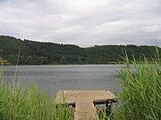
View of the east bank

View of the west bank

In the fog


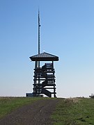
"Landesblick" observation tower

The Meerfelder Maar is a maar in the village of Meerfeld not far from the town of Manderscheid in the Eifel in the Rhineland-Palatinate district of Bernkastel-Wittlich .
Emergence
The maar is at least 30,000 years old and, according to the latest findings, is probably even 40,000 years old. In 1978 the lake sediments were examined to determine the exact age. Numerous wells have been carried out in the Meerfelder Maar to date .
It was created by a huge underground phreatomagmatic explosion that is triggered when hot magma hits a water-rich rock layer as it ascends. Due to the explosively evaporating water, the surrounding rocks are shattered and partly thrown upwards. The resulting cavity fills again with rock and a burglar funnel is created on the surface. The magma chamber from which the magma rose is about 2000 to 6000 m below the Meerfelder Maar.
construction
The total crater has an extension of 1400 m in east-west and 1200 m in north-south and is approximately 125 hectares in size. It is therefore one of the large maars in the Eifel. The highest elevation of the crater rim is on the north side at 515.9 m above sea level. NHN , on which there is also the Landesblick , a 12 m high wooden observation tower . Half of the maar basin is occupied by the maar lake today. The village of Meerfeld is located on the southern edge of the basin, still within the hollow shape created by the eruption.
Maar lake
In the course of time, the maar has filled with water, creating today's maar lake, the greatest depth of which is 17 m. It is 780 m long (W – E) and 490 m wide (N – S), the water surface of the Maarsee is 336.6 m above sea level. NHN .
In the years 1877 to 1880 the water level of the lake was artificially lowered to create meadows and pastureland. The state and the province assumed the cost of 12,000 gold marks , for which the municipality of Meerfeld erected a memorial column in 1890 as a thank you.
Since the beginning of the 20th century, the maar lake was in an over-fertilized ( polytrophic ) state. Until 1984 the water became very cloudy during the summer months and had a yellow-brown color, which came from a blue-green algae . In 1982 the Meerfelder Maar was therefore rehabilitated with deep drainage.
The lake itself is characterized by increasing siltation . This is also reflected in the vegetation. In the bank areas, large areas are overgrown with water-loving plants such as cattails , reeds , rushes , water lilies , hemlocks and yellow irises . There are around 15 species of fish in the Maarsee. A fishing license is available in all restaurants in the municipality.
Since 1986, the maar with the damp marginal areas and the deciduous forest in the area of the maar basin has been a nature reserve .
See also
literature
- Martina Stebich: Palynological studies on the vegetation history of the Vistula Late Glacial and Early Holocene on annually layered sediments of the Meerfelder Maar (Eifel) . Dissertationes Botanicae 320, Stuttgart 1999, ISBN 3-443-64232-2 .
- Werner P. D'hein: Vulkanland Eifel. Nature and culture guide, with 26 stations on the "German Volcano Road". Gaasterland-Verlag, Düsseldorf 2006, ISBN 3-935873-15-8 , ISBN 978-3-935873-15-4 .
- J. F. W. Negendank et al .: The Meerfelder Maar Lake Deposits . In: Journal of Glacier Science and Glacial Geology . tape 21 . Innsbruck 1985, p. 67–70 ( online, PDF, 600 kB, English [accessed March 20, 2016]).
Web links
- The Meerfelder Maar. Further information on the Meerfeld website
Individual evidence
- ↑ Hans-Ulrich Schmincke : Volcanoes of the Eifel. Structure, origin and today's meaning. Spektrum, Heidelberg 2009, ISBN 978-3-8274-2366-5 , p. 78.
- ↑ a b Map service of the landscape information system of the Rhineland-Palatinate nature conservation administration (LANIS map) ( notes ) (DTK 1: 5,000 color)
- ^ Ordinance on the nature reserve "Meerfelder Maar". (PDF) Trier district government, December 2, 1985, accessed on May 27, 2015 .

Coordinates: 50 ° 6 ′ 2 ″ N , 6 ° 45 ′ 23 ″ E