Wolf garden
|
Wolf garden
City of Schleiden
Coordinates: 50 ° 35 ′ 25 ″ N , 6 ° 29 ′ 34 ″ E
|
||
|---|---|---|
| Height : | 511 m above sea level NHN | |
| Residents : | 211 (Oct 31, 2015) | |
| Postal code : | 53937 | |
| Area code : | 02444 | |
|
Location of Wolfgarten in North Rhine-Westphalia |
||
|
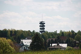
Wolfgarten with a former fire watchtower
|
||
Wolf Garten is a northern district of the Eifel located Schleiden in North Rhine-Westphalia Euskirchen . In the village live about 210 people.
Geographical location
Wolf Garten is located in Kermeter , a mountain range in the northern Eifel region in the Eifel National Park . The larger local rivers include the Lorbach and the Große Böttenbach , which arise north-north-west and north of the village and flow off to the Urftstausee to the west, as well as the Eselsbach , which rises east of the village and flows to the east-running Rotbach . On the southeastern outskirts of the village, on the highest (unnamed) elevation of the Kermeter ( 527.8 m above sea level ) stood the former Wolfgarten fire watch tower, which served as a lookout tower (which collapsed after a fire on June 13, 2017), and the Mariawald forest houses on the northeast and east and Wolfgarten .
history
Wolfgarten was founded around 1470 as a hereditary lease under the sovereignty of Jülich , is the place of origin of the Wolfgarten family, who also belong to Wolffgarten u. Ä. wrote.
At the beginning of the 19th century, Wolfgarten belonged to Mairie Gemünd .
Due to § 9 of the Aachen law , the place was incorporated together with the city of Gemünd on January 1, 1972 in the new city of Schleiden.
traffic
The L 249 runs through Wolfgarten . The next motorway junctions are Bad Münstereifel / Mechernich on the A 1 and Aachen-Lichtenbusch on the A 44 .
Web link
Individual evidence
- ↑ a b Demographics of the city of Schleiden, main residence ( memento of the original from March 4, 2016 in the Internet Archive ) Info: The archive link has been inserted automatically and has not yet been checked. Please check the original and archive link according to the instructions and then remove this notice. (PDF; 20 kB)
- ^ Federal Statistical Office (ed.): Historical municipality directory for the Federal Republic of Germany. Name, border and key number changes in municipalities, counties and administrative districts from May 27, 1970 to December 31, 1982 . W. Kohlhammer, Stuttgart / Mainz 1983, ISBN 3-17-003263-1 , p. 309 .


