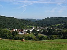
Bruch (Eifel)
| coat of arms | Germany map | |
|---|---|---|

|
Coordinates: 49 ° 57 ' N , 6 ° 47' E |
|
| Basic data | ||
| State : | Rhineland-Palatinate | |
| County : | Bernkastel-Wittlich | |
| Association municipality : | Wittlich-Land | |
| Height : | 190 m above sea level NHN | |
| Area : | 8.63 km 2 | |
| Residents: | 480 (Dec. 31, 2019) | |
| Population density : | 56 inhabitants per km 2 | |
| Postal code : | 54518 | |
| Area code : | 06578 | |
| License plate : | WIL, BKS | |
| Community key : | 07 2 31 013 | |
| Association administration address: | Kurfürstenstrasse 1 54516 Wittlich |
|
| Website : | ||
| Local Mayor : | Walter Schmitz | |
| Location of the local community of Bruch in the Bernkastel-Wittlich district | ||
Bruch is a municipality in the Bernkastel-Wittlich district in Rhineland-Palatinate . It belongs to the Verbandsgemeinde Wittlich-Land .
Geographical location
Bruch is located in the Eifel on the Eifelsteig long-distance hiking trail about 10 kilometers west of the district town of Wittlich at 190 m above sea level. NHN and lies on both sides of the Salm . The residential areas Brucher Burg , Haus Zender, Lerchenhof, Obere Mühle and Sonnenhof also belong to Bruch .
history
In the 1930s, remnants of a Roman villa complex were found north of the village of Bruch . The discovery of Roman cremation graves in the parish of the municipality also suggests that the first settlement was in the period from the 1st to the 3rd century.
Bruch is mentioned for the first time in 1138. A Fridelo de Brucha appears in the founding document of the Himmerod monastery . Until the von Bruch family died out around 1334, the history of the place was closely linked to the von Bruch family history. Then the rulership of Bruch went to Dietrich von Dune ( Daun ).
In the 16th century, Bruch was given its own jurisdiction . The corresponding gallows was located on the so-called Galgenberg east of the castle, on an old connection path to Bergweiler .
In the 18th century, the above-mentioned geographical position of the place led to a strange situation. The place belonged to two different territories , as the part to the west of the Salm belonged to the Duchy of Luxembourg and the eastern part to Kurtrier .
From 1794 onwards Bruch was under French rule, in 1815 the place was assigned to the Kingdom of Prussia at the Congress of Vienna . Since 1946 it has been part of the state of Rhineland-Palatinate.
Population development
The development of the population of the community of Bruch, the values from 1871 to 1987 are based on censuses:
|
|
politics
Municipal council
The municipal council in Bruch consists of eight council members, who were elected by a majority vote in the local elections on May 26, 2019 , and the honorary local mayor as chairman.
coat of arms
With permission from 1983, Bruch has the right to use its own coat of arms.
| Blazon : "Shield,divided diagonallyfrom top left to bottom right six times by gold and red, topped with a silver castle tower with a blue roof and two blue windows." | |
| Justification of the coat of arms: The diagonally split, red and gold shield was the coat of arms of the noble lords of Bruch, the first noble family who lived in the Bruch Castle as their ancestral seat as early as the first half of the 12th century. |
Culture and sights
Moated castle
The moated castle Bruch in a valley on the Salm surrounded by forest mountains dates with its older parts from the beginning of the 14th century and was the seat of the Lords von Bruch, who have been attested since the 12th century . Today the castle is in private hands.
More Attractions
- Castle House (Hepgesburg) (1413)
- Oil mill (from the 19th century, founded on one of the oldest salt mills from 1284)
- Pottery with an old jug oven from the 17th century
- Parish Church of St. Rochus (built 1807)
- disused copper mine from 1740
- Galgenberg, medieval place of execution
- Burgstrasse 6, sandstone figures and reliefs
Web links
- Official homepage of the local community of Bruch
- To search for cultural assets of the local community of Bruch in the database of cultural assets in the Trier region .
- Brief portrait of Bruch on SWR television
Individual evidence
- ↑ State Statistical Office of Rhineland-Palatinate - population status 2019, districts, communities, association communities ( help on this ).
- ↑ State Statistical Office Rhineland-Palatinate (ed.): Official directory of the municipalities and parts of the municipality. Status: January 2018 [ Version 2020 is available. ] . S. 57 (PDF; 2.2 MB).
- ↑ Dirk Lutz Krauße : German Archaeological Institute: Iron Age Cultural Change and Romanization in the Mosel-Eifel Region , catalog of sites, 2006, p. 13 ( Memento of March 8, 2014 in the Internet Archive ), accessed in the Internet archive on February 6, 2016 ( PDF; 1.2 MB)
- ↑ State Statistical Office Rhineland-Palatinate - regional data
- ^ The Regional Returning Officer Rhineland-Palatinate: Local elections 2019, city and municipal council elections


