
Losnich
| coat of arms | Germany map | |
|---|---|---|

|
Coordinates: 49 ° 58 ' N , 7 ° 3' E |
|
| Basic data | ||
| State : | Rhineland-Palatinate | |
| County : | Bernkastel-Wittlich | |
| Association municipality : | Bernkastel-Kues | |
| Height : | 120 m above sea level NHN | |
| Area : | 2.53 km 2 | |
| Residents: | 460 (December 31, 2019) | |
| Population density : | 182 inhabitants per km 2 | |
| Postal code : | 54492 | |
| Area code : | 06532 | |
| License plate : | WIL, BKS | |
| Community key : | 07 2 31 076 | |
| Association administration address: | Gestade 18 54470 Bernkastel-Kues |
|
| Website : | ||
| Local Mayor : | Winfried Gassen | |
| Location of the local community of Lösnich in the district of Bernkastel-Wittlich | ||
  |
||


Lösnich is a municipality in the district of Bernkastel-Wittlich in Rhineland-Palatinate . It belongs to the community of Bernkastel-Kues and is strongly influenced by viticulture and tourism .
history
From 1816 to 1969 the place belonged to the district of Bernkastel in the administrative district of Trier . After the Second World War, this became part of the Rhineland-Palatinate state, which was created in 1946 . During the district reform in 1969, the two districts of Bernkastel and Wittlich merged to form the new district of Bernkastel-Wittlich. The Bernkastel district (so called until 1938) included a total of nine mayor's offices as administrative units. These became offices in 1927. Losnich was part of the Zeltingen office until the offices were dissolved in 1968.
Losuniacum - possession of the lot - could have been a possible basic form of the place name Lösnich according to Franz Cramer and refer to a Celtic origin. In the 2nd to 4th centuries AD there was a larger Roman estate in the Losnich Hinterwald, consisting of eight building units with references to the processing of grapes. Excavation work by the Rheinisches Landesmuseum Trier on a Franconian burial ground near the Moselle uncovered a Franconian sarcophagus in 1937, where grave sites had already been discovered around 1900. The former Lösnich castle of the local knight family von Lösnich has been documented since 1368. As a former imperial rulership, Lösnich and its castle were elevated to an Electoral Cologne fief after the knights of Lösnich died out in the 14th century and this remained until the end of the feudal period in 1794. The former stately home of the Freiherr von Metternich and Barons are still visible signs of this time Imperial Count von Kesselstatt from 1683 on the former castle grounds and the old cross-vaulted cellar of the former castle from the 14th century.

The coat of arms of the Knights of Losnich on the epitaph of the knight Cuno VI. of Pirmont 1447

The stately home from 1683

The old castle cellar from the 14th century

Art Nouveau winegrower's villa, architect Bruno Möhring
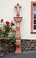
Crucifixion shrine, marked 1659


Municipal council
The local council in Lösnich consists of eight council members, who in the local elections on May 26, 2019 in a majority vote were elected, and the honorary mayor as chairman.
→ See also: List of Mayors of Losnich
Culture and sights

In addition to many old half-timbered houses, the Kesselstatt Office Building, the late Gothic cemetery chapel and the neo-Gothic parish church from 1879 are worth seeing.
Economy and Infrastructure
Lösnich has been shaped by viticulture and tourism for centuries . The Hochmosel crossing of federal road 50 was built directly near Lösnich .
See also
Web links
- Losnich
- To search for cultural assets of the local community of Lösnich in the database of cultural assets in the Trier region .
- Link catalog on the subject Lösnich at curlie.org (formerly DMOZ )
Individual evidence
- ↑ State Statistical Office of Rhineland-Palatinate - population status 2019, districts, communities, association communities ( help on this ).
- ^ Franz Cramer: Rhenish place names from pre-Roman times . Düsseldorf, Linz 1901.
- ↑ Anastasia Moraitis: The Roman manor and the grave field near Lösnich, Bernkastel-Wittlich district . In: Trier magazine . Supplement 26. Self-published by the Rheinisches Landesmuseum, Trier 2003, ISBN 3-923319-54-1 .
- ↑ Kurt Böhner: The Franconian antiquities of the Trier country . Part 2. Verlag Gebr. Mann, Berlin 1958, p. 69 f .
- ^ Hans Vogts: The art monuments of the Bernkastel district . Reprint of the edition from 1935, Verlag der Akademischen Buchhandlung Interbook, Trier.
- ^ The Regional Returning Officer Rhineland-Palatinate: Local elections 2019, city and municipal council elections
Bernkastel-Kues | Brauneberg | Castles | Earth | Gornhausen | Graach an der Mosel | Hochscheid | Kesten | Kleinich | Coming | Readers | Losnich | Longkamp | Maring-Noviand | Minheim | Monzelfeld | Mülheim an der Mosel | Neumagen-Dhron | Piesport | Ürzig | Veldenz | Wintrich | Zeltingen-Rachtig

Altrich | Arenrath | Bausendorf | Brat | Mountain light | Mountain hamlet | Bernkastel-Kues | Bettenfeld | Binsfeld | Brauneberg | Wide | Break | Büdlich | Castle (Mosel) | Castles | Burtscheid | Deuselbach | Throne corners | Diefenbach | Dierfeld | Dierscheid | Dodenburg | Three | Corner field | Eisenschmitt | Enkirch | Earth | Esch | Etgert | River stream | Gielert | Gipperath | Gladbach | Gornhausen | Graach an der Mosel | Gräfendhron | Greimerath | Großlittgen | Hasborn | Heckenmünster | Heidenburg | Heidweiler | Hetzerath | Hilscheid | Hochscheid | Hontheim | Horath | Hupperath | Immert | Irmenach | Karl | Kesten | Kinderbeuern | Kinheim | Klausen | Kleinich | Coming | Kröv | Landscheid | Laufeld | Readers | Longkamp | Losnich | Lötzbeuren | Lückenburg | Malborn | Manderscheid | Maring-Noviand | Meerfeld | Merschbach | Minority | Minheim | Monzelfeld | Morbach | Mülheim an der Mosel | Musweiler | Neumagen-Dhron | Neunkirchen | Niederöfflingen | Niederscheidweiler | Niersbach | Oberöfflingen | Oberscheidweiler | Osann-Monzel | Pantenburg | Piesport | Plates | Plein | Reil | Rivenich | Rorodt | Salmtal | Schladt | Schoenberg | Schwarzenborn | Sehlem | Starkenburg | Talling | Thalfang | Traben-Trarbach | Ürzig | Veldenz | Wallscheid | Willwerscheid | Wintrich | Wittlich | Zeltingen-Rachtig