
Thalfang
| coat of arms | Germany map | |
|---|---|---|

|
Coordinates: 49 ° 45 ' N , 7 ° 0' E |
|
| Basic data | ||
| State : | Rhineland-Palatinate | |
| County : | Bernkastel-Wittlich | |
| Association municipality : | Thalfang at the Erbeskopf | |
| Height : | 460 m above sea level NHN | |
| Area : | 19.44 km 2 | |
| Residents: | 1803 (Dec. 31, 2019) | |
| Population density : | 93 inhabitants per km 2 | |
| Postal code : | 54424 | |
| Area code : | 06504 | |
| License plate : | WIL, BKS | |
| Community key : | 07 2 31 123 | |
| Association administration address: | Saarstrasse 7 54424 Thalfang |
|
| Website : | ||
| Local Mayor : | Burkhard Graul ( SPD ) | |
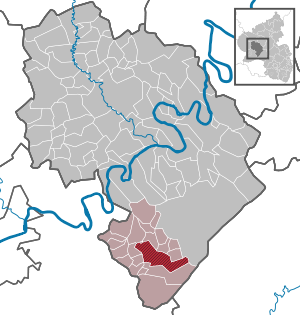
| Location of the local community Thalfang in the district of Bernkastel-Wittlich | ||
  |
||


Thalfang is a local community and the administrative seat of the Verbandsgemeinde Thalfang am Erbeskopf in the district of Bernkastel-Wittlich in Rhineland-Palatinate . It is located on the Erbeskopf in the Hunsrück and is a state-approved health resort .
geography
Thalfang on the Hunsrückhöhenstrasse is located in the western Hunsrück , about seven kilometers northwest of the Erbeskopf . The Haardtwald forest is north of the village . The Thalfanger Bach flows through the village with the Klingelbach , Marschtelerbach and Hohlbachsflößchen backwaters .
The districts of Berghof, Flürchen, Gatschmühle, Hasenborn, Hubertushof and Ziegelei belong to the main town of Thalfang. The district of Bäsch includes Eichelhof, Forsthaus Deuselbach and Thalfang (train station).
history
The area around Thalfang was first mentioned in a document in 633. From the 12th century Thalfang belonged to the Thalfang mark , which was later referred to as the Dhronecken office .
On a map of the Archdiocese of Trier from 1645, the place is shown as Thalfinck .
It was not until the French rule in 1800 that the Dhronecken office was dissolved, which was created by Mairie Thalfang in the canton of Hermeskeil in the Saardepartements . The places Bäsch , Burtscheid , Deuselbach , Dhronecken , Etgert , Hilscheid , Immert , Malborn , Rorodt and Röderbach, which was abandoned around 1900 , also belonged to Mairie Thalfang . Due to the resolutions at the Congress of Vienna , the place came to the Kingdom of Prussia in 1815 ; Thalfang became the administrative seat of the mayor's office of the same name , which was assigned to the Bernkastel district and the Trier administrative district . Thalfang has belonged to the state of Rhineland-Palatinate since 1946. On June 7, 1969, the local community of Bäsch was incorporated into Thalfang.
In terms of other historical events, it should be noted that Erich Honecker had worked as a roofer apprentice in the construction of what was then the town hall in the 1920s.
- Population development
The development of the population of Thalfang in relation to today's municipality, the values from 1871 to 1987 are based on censuses:
|
|
politics
Municipal council
The local council in Thalfang consists of 16 council members, who were elected in a personalized proportional representation in the local elections on May 26, 2019 , and the honorary local mayor as chairman.
The distribution of seats in the municipal council:
| choice | SPD | CDU | FDP | FL | total |
|---|---|---|---|---|---|
| 2019 | 5 | 5 | 2 | 4th | 16 seats |
| 2014 | 6th | 5 | 2 | 3 | 16 seats |
| 2009 | 5 | 5 | 3 | 3 | 16 seats |
| 2004 | 5 | 6th | 2 | 3 | 16 seats |
| 1999 | 5 | 7th | 2 | 2 | 16 seats |
- FL = Thalfanger Free List e. V.
Local mayor
- Franz-Josef Gasper, CDU, until the end of 2010
- Burkhard Graul, SPD, from 2011
coat of arms
|
|
|
| Reasons for the coat of arms: The red cross on a silver background refers to the former membership of the Electorate of Trier . The two Salme surrounded by the crosses come from the Count of Salm . They remember Count Ernst, the only one from the Wild and Rhine Counts , who was buried in the cemetery in Thalfang and on whose tombstone this Salme was also depicted. The grave has meanwhile been leveled. The “rust”, the entrance to the church square, is a symbol for the oldest buildings in Thalfang. |
Parish partnership
- Villeneuve-la-Guyard , France
Culture and sights
Sights of the place are for example the Haardtwaldquelle , Villeneuver-Platz, Samuel-Hirsch-Platz, the war memorial, the Catholic church, the Gothic Protestant church or the Jewish cemetery Thalfang .
Economy and Infrastructure
traffic
Thalfang is on the Hunsrückhöhenstrasse between Hermeskeil and Morbach . The disused Hunsrückquerbahn also runs through the village .
tourism
The climatic health resort Thalfang has an indoor swimming pool / health center and a spa park with ponds.
The Himmelberg holiday park is located on the road to Lückenburg ( K 110 ) .
Industry and commerce
Hochwald Foods GmbH , the largest commercial enterprise in the Trier region and one of the largest dairy companies in Germany, is based in Thalfang .
Thalfang is the bottling place of the following officially recognized natural mineral waters : Berg-Quelle, Brillant-Quelle, Del-Bon-Quelle, Erbeskopf-Quelle (Malborn), Diamant-Quelle, Haardtwald -Quelle, Hunsrück-Quelle and Thalquelle. Hochwald Sprudel from Schwollen has a production site in Thalfang.
Numerous small and medium-sized companies are based in the village. Robert-Reisen is a bus travel company from Thalfang.
In addition, there is the Thalfang branch of Sparkasse Mittelmosel Eifel Mosel Hunsrück (headquarters in Bernkastel-Kues ), the Thalfang branch of VR-Bank Hunsrück-Mosel eG (headquarters in Morbach ) and the Postbank branch Thalfang.
Personalities
- The most important son of Thalfang is the rabbi and philosopher Samuel Hirsch (1815–1889).
- The German technician and chemist Wilhelm Kathol died in Thalfang in 1944.
See also
literature
- Elmar P. Ittenbach: Jewish life in Thalfang: history and fates , Paulinus , Trier 2011, ISBN 978-3-7902-1900-5 (= writings of the Emil Frank Institute , volume 14).
Web links
- Internet presence of the municipality of Thalfang
- Link catalog on the subject of Thalfang at curlie.org (formerly DMOZ )
Individual evidence
- ↑ a b State Statistical Office of Rhineland-Palatinate - population status 2019, districts, municipalities, association communities ( help on this ).
- ↑ a b State Statistical Office Rhineland-Palatinate - regional data
- ↑ State Statistical Office Rhineland-Palatinate (ed.): Official directory of the municipalities and parts of the municipality. Status: January 2018 [ Version 2020 is available. ] . S. 56 (PDF; 2.2 MB).
- ↑ Mark Thalfang
- ↑ Official municipality directory 2006 ( Memento from December 22, 2017 in the Internet Archive ) (= State Statistical Office Rhineland-Palatinate [Hrsg.]: Statistical volumes . Volume 393 ). Bad Ems March 2006, p. 197 (PDF; 2.6 MB). Info: An up-to-date directory ( 2016 ) is available, but in the section "Territorial changes - Territorial administrative reform" it does not give any population figures.
- ^ The Regional Returning Officer Rhineland-Palatinate: Local elections 2019, city and municipal council elections
- ↑ Series of publications by the Emil Frank Institute at the University of Trier
Mountain light | Wide | Büdlich | Burtscheid | Deuselbach | Throne corners | Etgert | Gielert | Gräfendhron | Heidenburg | Hilscheid | Horath | Immert | Lückenburg | Malborn | Merschbach | Neunkirchen | Rorodt | Schoenberg | Talling | Thalfang

Altrich | Arenrath | Bausendorf | Brat | Mountain light | Mountain hamlet | Bernkastel-Kues | Bettenfeld | Binsfeld | Brauneberg | Wide | Break | Büdlich | Castle (Mosel) | Castles | Burtscheid | Deuselbach | Throne corners | Diefenbach | Dierfeld | Dierscheid | Dodenburg | Three | Corner field | Eisenschmitt | Enkirch | Earth | Esch | Etgert | River stream | Gielert | Gipperath | Gladbach | Gornhausen | Graach an der Mosel | Gräfendhron | Greimerath | Großlittgen | Hasborn | Heckenmünster | Heidenburg | Heidweiler | Hetzerath | Hilscheid | Hochscheid | Hontheim | Horath | Hupperath | Immert | Irmenach | Karl | Kesten | Kinderbeuern | Kinheim | Klausen | Kleinich | Coming | Kröv | Landscheid | Laufeld | Readers | Longkamp | Losnich | Lötzbeuren | Lückenburg | Malborn | Manderscheid | Maring-Noviand | Meerfeld | Merschbach | Minority | Minheim | Monzelfeld | Morbach | Mülheim an der Mosel | Musweiler | Neumagen-Dhron | Neunkirchen | Niederöfflingen | Niederscheidweiler | Niersbach | Oberöfflingen | Oberscheidweiler | Osann-Monzel | Pantenburg | Piesport | Plates | Plein | Reil | Rivenich | Rorodt | Salmtal | Schladt | Schoenberg | Schwarzenborn | Sehlem | Starkenburg | Talling | Thalfang | Traben-Trarbach | Ürzig | Veldenz | Wallscheid | Willwerscheid | Wintrich | Wittlich | Zeltingen-Rachtig