
Dierscheid
| coat of arms | Germany map | |
|---|---|---|

|
Coordinates: 49 ° 54 ' N , 6 ° 45' E |
|
| Basic data | ||
| State : | Rhineland-Palatinate | |
| County : | Bernkastel-Wittlich | |
| Association municipality : | Wittlich-Land | |
| Height : | 400 m above sea level NHN | |
| Area : | 2.42 km 2 | |
| Residents: | 180 (Dec. 31, 2019) | |
| Population density : | 74 inhabitants per km 2 | |
| Postal code : | 54523 | |
| Area code : | 06508 | |
| License plate : | WIL, BKS | |
| Community key : | 07 2 31 022 | |
| Association administration address: | Kurfürstenstrasse 1 54516 Wittlich |
|
| Website : | ||
| Local Mayor : | Dirk Lautwein | |
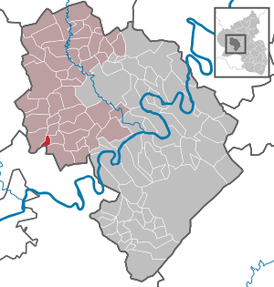
| Location of the local community Dierscheid in the district of Bernkastel-Wittlich | ||
  |
||

Dierscheid im Meulenwald is a municipality in the Bernkastel-Wittlich district in Rhineland-Palatinate . It belongs to the Verbandsgemeinde Wittlich-Land .
geography

The place is located southwest of Wittlich at about 400 m above sea level. NHN . In Dierscheid lies the Kellerberg , at 448 m above sea level. NHN the highest mountain in the Wittlich-Land community.
history
Remnants of Roman walls are evidence of early settlement. Corresponding finds are partially exhibited in the local history museum.
Dierscheid was first mentioned in 1150 in a document from the Sankt Maximin Abbey in Trier . In the 13th century the place was called Dyrseit . The gentlemen von Bruch had the tithe rights in the parish of Heidweiler , which also included the Dierscheid branch. In January 1417 the name changed to Diescheit . The spelling for the name of the place changed very often: Dierscheid, Dierschet, Dischet, Dirscheit, Dierscheydt, Dierscheit, Dyrseit and Derseit .
Dierscheid belonged to the Bruch rule , so it was under Luxembourg sovereignty. From 1794 Dierscheid was under French rule, in 1815 the place was assigned to the Kingdom of Prussia at the Congress of Vienna . Since 1946 it has been part of the then newly formed state of Rhineland-Palatinate.
Until the 1950s, Dierscheid was characterized by agriculture, timber industry and Kieselkloppen. Under the name Dierscheider Kieselklopper , the residents are still known far beyond the borders.
politics
Municipal council
The council in Dierscheid consists of six council members, who in the local elections on May 26, 2019 in a majority vote were elected, and the honorary mayor as chairman.
coat of arms
|
|
Blazon : "In silver on a red three-mountain, in it a golden stag pole, three green spruce trees with golden cones." |
| Coats of arms: This so-called speaking coat of arms provides information about the place name and the geographical location. "Dier" means as much as roe deer - therefore spruce and horns. The base of the shield symbolizes the location of the place on a mountain height in the Voreifel . The colors silver and red are reminiscent of the membership in the Electorate of Trier . |
Attractions
- Kellerberg as the highest point in the southern Eifel
- Village archive and local history museum , housed in a former wheelwright workshop from around 1900
- Laurentiuskapelle from 1796 , built on a previously burned down chapel from 1745
- Learning oven in the former school
See also:
Web links
- Website of the local community Dierscheid
- Link catalog on the topic of Dierscheid at curlie.org (formerly DMOZ )
Individual evidence
- ↑ State Statistical Office of Rhineland-Palatinate - population status 2019, districts, communities, association communities ( help on this ).
- ^ The Regional Returning Officer Rhineland-Palatinate: Local elections 2019, city and municipal council elections

Altrich | Arenrath | Bausendorf | Brat | Mountain light | Mountain hamlet | Bernkastel-Kues | Bettenfeld | Binsfeld | Brauneberg | Wide | Break | Büdlich | Castle (Mosel) | Castles | Burtscheid | Deuselbach | Throne corners | Diefenbach | Dierfeld | Dierscheid | Dodenburg | Three | Corner field | Eisenschmitt | Enkirch | Earth | Esch | Etgert | River stream | Gielert | Gipperath | Gladbach | Gornhausen | Graach an der Mosel | Gräfendhron | Greimerath | Großlittgen | Hasborn | Heckenmünster | Heidenburg | Heidweiler | Hetzerath | Hilscheid | Hochscheid | Hontheim | Horath | Hupperath | Immert | Irmenach | Karl | Kesten | Kinderbeuern | Kinheim | Klausen | Kleinich | Coming | Kröv | Landscheid | Laufeld | Readers | Longkamp | Losnich | Lötzbeuren | Lückenburg | Malborn | Manderscheid | Maring-Noviand | Meerfeld | Merschbach | Minority | Minheim | Monzelfeld | Morbach | Mülheim an der Mosel | Musweiler | Neumagen-Dhron | Neunkirchen | Niederöfflingen | Niederscheidweiler | Niersbach | Oberöfflingen | Oberscheidweiler | Osann-Monzel | Pantenburg | Piesport | Plates | Plein | Reil | Rivenich | Rorodt | Salmtal | Schladt | Schoenberg | Schwarzenborn | Sehlem | Starkenburg | Talling | Thalfang | Traben-Trarbach | Ürzig | Veldenz | Wallscheid | Willwerscheid | Wintrich | Wittlich | Zeltingen-Rachtig