
Arenrath
| coat of arms | Germany map | |
|---|---|---|

|
Coordinates: 49 ° 57 ' N , 6 ° 44' E |
|
| Basic data | ||
| State : | Rhineland-Palatinate | |
| County : | Bernkastel-Wittlich | |
| Association municipality : | Wittlich-Land | |
| Height : | 265 m above sea level NHN | |
| Area : | 6.77 km 2 | |
| Residents: | 394 (Dec. 31, 2019) | |
| Population density : | 58 inhabitants per km 2 | |
| Postal code : | 54518 | |
| Area code : | 06575 | |
| License plate : | WIL, BKS | |
| Community key : | 07 2 31 003 | |
| LOCODE : | DE 8AT | |
| Association administration address: | Kurfürstenstrasse 1 54516 Wittlich |
|
| Website : | ||
| Local Mayor : | Ludwig Schmitz | |
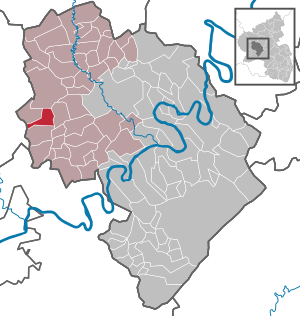
| Location of the local community Arenrath in the district of Bernkastel-Wittlich | ||
  |
||

Arenrath in the Eifel is a municipality in the district of Bernkastel-Wittlich in Rhineland-Palatinate . It belongs to the Verbandsgemeinde Wittlich-Land .
geography
location
The place is about 13 km west of the district town of Wittlich , between Bruch and Binsfeld .
geology
Arenrath is known for the Moselle agates from the local gravel pits.
history
In the Middle Ages, Arenrath, first mentioned in a document as Arendroch in 1156 , formed its own rule in the Kurstaat Trier . Since 1946 the place has been part of the state of Rhineland-Palatinate .
politics
Municipal council
The council in Arenrath consists of eight council members, who in the local elections on May 26, 2019 in a majority vote were elected, and the honorary mayor as chairman.
mayor
The local mayor is Ludwig Schmitz.
coat of arms
In 1982 Arenrath received approval to use its own coat of arms.
Coat of arms description : "arms of silver right steps beams divided up into green left three golden ears of corn, down in red a silver sleeves with silver hand holding a golden bowl."
The silver graduation of the shield and the beggar's bowl are symbols of the church patron Saint Alexius, who is depicted as a beggar under the stairs in the legend. The ears of wheat indicate the agriculture, the green field the name of the place - the clearing of the Arend. Green means forest and field and red and silver are reminiscent of the Trier electoral rule.
Attractions
A natural monument is the so-called " Devil's Stone ", a sandstone that lies in the area of the border between Bruch and Arenrath.
literature
- Literature about Arenrath in the Rhineland-Palatinate State Bibliography
Web links
- Official website of the municipality of Arenrath
- Brief portrait of Arenrath at Hierzuland , SWR television
- To search for cultural assets of the local community Arenrath in the database of cultural assets in the Trier region .
- Link catalog on the subject of Arenrath at curlie.org (formerly DMOZ )
Individual evidence
- ↑ State Statistical Office of Rhineland-Palatinate - population status 2019, districts, communities, association communities ( help on this ).
- ^ The Regional Returning Officer Rhineland-Palatinate: Local elections 2019, city and municipal council elections
- ↑ Entry on the “Teufelsstein” natural monument in the database of cultural assets in the Trier region ; accessed on January 9, 2016.

Altrich | Arenrath | Bausendorf | Brat | Mountain light | Mountain hamlet | Bernkastel-Kues | Bettenfeld | Binsfeld | Brauneberg | Wide | Break | Büdlich | Castle (Mosel) | Castles | Burtscheid | Deuselbach | Throne corners | Diefenbach | Dierfeld | Dierscheid | Dodenburg | Three | Corner field | Eisenschmitt | Enkirch | Earth | Esch | Etgert | River stream | Gielert | Gipperath | Gladbach | Gornhausen | Graach an der Mosel | Gräfendhron | Greimerath | Großlittgen | Hasborn | Heckenmünster | Heidenburg | Heidweiler | Hetzerath | Hilscheid | Hochscheid | Hontheim | Horath | Hupperath | Immert | Irmenach | Karl | Kesten | Kinderbeuern | Kinheim | Klausen | Kleinich | Coming | Kröv | Landscheid | Laufeld | Readers | Longkamp | Losnich | Lötzbeuren | Lückenburg | Malborn | Manderscheid | Maring-Noviand | Meerfeld | Merschbach | Minority | Minheim | Monzelfeld | Morbach | Mülheim an der Mosel | Musweiler | Neumagen-Dhron | Neunkirchen | Niederöfflingen | Niederscheidweiler | Niersbach | Oberöfflingen | Oberscheidweiler | Osann-Monzel | Pantenburg | Piesport | Plates | Plein | Reil | Rivenich | Rorodt | Salmtal | Schladt | Schoenberg | Schwarzenborn | Sehlem | Starkenburg | Talling | Thalfang | Traben-Trarbach | Ürzig | Veldenz | Wallscheid | Willwerscheid | Wintrich | Wittlich | Zeltingen-Rachtig