
Lötzbeuren
| coat of arms | Germany map | |
|---|---|---|

|
Coordinates: 49 ° 56 ' N , 7 ° 13' E |
|
| Basic data | ||
| State : | Rhineland-Palatinate | |
| County : | Bernkastel-Wittlich | |
| Association municipality : | Traben-Trarbach | |
| Height : | 430 m above sea level NHN | |
| Area : | 10.2 km 2 | |
| Residents: | 434 (Dec. 31, 2019) | |
| Population density : | 43 inhabitants per km 2 | |
| Postal code : | 56843 | |
| Area code : | 06543 | |
| License plate : | WIL, BKS | |
| Community key : | 07 2 31 206 | |
| Association administration address: | Am Markt 3 56841 Traben-Trarbach |
|
| Website : | ||
| Local Mayor : | Thomas Alexander Barth | |
| Location of the local community of Lötzbeuren in the Bernkastel-Wittlich district | ||
  |
||

Lötzbeuren im Hunsrück is a municipality in the district of Bernkastel-Wittlich in Rhineland-Palatinate . It belongs to the Traben-Trarbach community . Frankfurt-Hahn Airport is located near Lötzbeuren .
history
Little is known about the history of Lötzbeuren in the Middle Ages. Between the Palatinate and Baden common rulers of the county of Sponheim it was controversial until the 18th century whether the place should be included in the rear or the front county. In 1332 Lötzbeuren was owned by the Vordere Grafschaft, but it seems to have passed to the Hinterere Grafschaft in 1417, but the rulers of the Vorderen Grafschaft tried again and again to assert rights, in particular Baden , which Lötzbeuren claimed for the Vordere Grafschaft and since 1707 as Baden property looked at, but without having sustainable success. In 1776, Baden finally renounced the place in favor of Pfalz-Zweibrücken . At the same time there was also a dispute with the Electorate of Trier over sovereignty. Since the Electorate of Trier serfs made up the overwhelming majority of the population, Trier counted the village in his possession. There were also other claims of ownership by other gentlemen, so that the situation remained very complicated. From 1673 it is known that 36 subjects lived in Lötzbeuren , 16 of whom were Trier , 7 Sponheim, 4 Palatinate-Simmerian , 4 Rhine Count , 4 Oberstein and 1 Schmidtburg . Remarkably, only two were not Lutheran: a native-born citizen was Catholic, a Palatinate-Simmerian was Reformed. From this it can be seen that Pfalz-Birkenfeld , the more influential of the two common rulers from Hinterspoon, was ultimately able to assert himself at least in church terms. It is not possible to say exactly when and how the Reformation was introduced in Lötzbeuren, but it will probably not have been long after 1557 in which year the rear county of Sponheim received the Reformation. To this day Lötzbeuren is so evangelical.
Because of the complicated circumstances, the residents of Lötzbeuren probably understood Lötzbeuren as a “free village” in which no master had rights other than those he could exercise on his serfs. No high court judge was recognized either. In the event of a crime, one had to turn to the respective competent judge of the serf concerned . This is the only way to understand the verses with which Pastor Caspar Streccius, who left Lötzbeuren in a dispute in 1632/33 in order to take up the Irmenach pastorate, addressed the community:
- Then I remembered
- To Lützbeurn to stay forever,
- For it is a very nefarious people
- Can not be regir'n at any time.
- Are many rulers under sound,
- Nobody wants to rule oneself wages.
The current church dates from 1718. Inside there are numerous paintings, some of which were only rediscovered in the 1950s. The church also houses a single-manual Stumm organ from 1745.
When the rear county of Sponheim was divided in 1776, Lötzbeuren and the entire Trarbach District Office also came to Pfalz-Zweibrücken-Birkenfeld . The history of the county ended in the wars that followed the French Revolution. The area came into Prussian possession in 1815 and Lötzbeuren was assigned to the Sohren mayor's office in the new Zell district . Since 1946 the place has been part of the then newly formed state of Rhineland-Palatinate . In 1969 Lötzbeuren briefly belonged to the Rhein-Hunsrück district until it was incorporated into the Traben-Trarbach community in the district of Bernkastel-Wittlich in 1970 at its own request .
politics
Municipal council
The local council in Lötzbeuren consists of eight council members, who were elected in the local elections on May 26, 2019 in a majority vote, and the honorary local mayor as chairman. Until 2014, the municipality council had twelve council members.
coat of arms
The blazon reads: "Divided, above in a golden field a blue plow, below in a red field a silver rust".
The plow indicates the old occupation of the villagers in agriculture. The rust is the attribute of St. Laurentius , the church patron of the parish. The colors red and silver refer to the rear county of Sponheim, which was connected to the place for centuries. Design: A. Friderichs, Zell / Mosel

Evangelical Church in Lötzbeuren
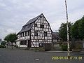
Half-timbered house in the center of the village


Churches
Two thirds of the residents are Protestant and belong to the Protestant parish of Irmenach -Lötzbeuren- Raversbeuren , which is parishally connected to the parish of Enkirch-Starkenburg, in the parish of Simmern-Trarbach . The parish seat is Enkirch .
See also
literature
- Friedrich Back , Heinrich Rodewald : The parish Lötzbeuren. In: Monthly Issues for Rhenish Church History 19 (1925), pp. 69–78.
Web links
- Internet presence of the local community Lötzbeuren
- To search for cultural assets of the local community Lötzbeuren in the database of cultural assets in the Trier region .
Individual evidence
- ↑ State Statistical Office of Rhineland-Palatinate - population status 2019, districts, communities, association communities ( help on this ).
- ^ Heinrich Rodewald : Irmenach at the time of the destruction of Grevenburg and the religious confusion in Baden. 1697-1734. In: Monthly Issues for Rhenish Church History 7 (1913), pp. 129–187. Here: p. 164
- ^ Johannes Mötsch : Die Grafschaften Sponheim , Geschichtlicher Atlas der Rheinlandes, Supplement V / 4, Rheinland-Verlag, Cologne 1992, p. 69.
- ^ Heinrich Rodewald: Caspar Streccius. A native pastor's life from the time of the great war. In: Monthly Issues for Rheinische Kirchengeschichte 9 (1915), pp. 129–160. Quote: p. 137.
- ^ The Regional Returning Officer Rhineland-Palatinate: Local elections 2019, city and municipal council elections
Bausendorf | Brat | Castle | Diefenbach | Enkirch | River stream | Hontheim | Irmenach | Kinderbeuern | Kinheim | Kröv | Lötzbeuren | Reil | Starkenburg | Traben-Trarbach | Willwerscheid

Altrich | Arenrath | Bausendorf | Brat | Mountain light | Mountain hamlet | Bernkastel-Kues | Bettenfeld | Binsfeld | Brauneberg | Wide | Break | Büdlich | Castle (Mosel) | Castles | Burtscheid | Deuselbach | Throne corners | Diefenbach | Dierfeld | Dierscheid | Dodenburg | Three | Corner field | Eisenschmitt | Enkirch | Earth | Esch | Etgert | River stream | Gielert | Gipperath | Gladbach | Gornhausen | Graach an der Mosel | Gräfendhron | Greimerath | Großlittgen | Hasborn | Heckenmünster | Heidenburg | Heidweiler | Hetzerath | Hilscheid | Hochscheid | Hontheim | Horath | Hupperath | Immert | Irmenach | Karl | Kesten | Kinderbeuern | Kinheim | Klausen | Kleinich | Coming | Kröv | Landscheid | Laufeld | Readers | Longkamp | Losnich | Lötzbeuren | Lückenburg | Malborn | Manderscheid | Maring-Noviand | Meerfeld | Merschbach | Minority | Minheim | Monzelfeld | Morbach | Mülheim an der Mosel | Musweiler | Neumagen-Dhron | Neunkirchen | Niederöfflingen | Niederscheidweiler | Niersbach | Oberöfflingen | Oberscheidweiler | Osann-Monzel | Pantenburg | Piesport | Plates | Plein | Reil | Rivenich | Rorodt | Salmtal | Schladt | Schoenberg | Schwarzenborn | Sehlem | Starkenburg | Talling | Thalfang | Traben-Trarbach | Ürzig | Veldenz | Wallscheid | Willwerscheid | Wintrich | Wittlich | Zeltingen-Rachtig