
Plein
| coat of arms | Germany map | |
|---|---|---|

|
Coordinates: 50 ° 2 ′ N , 6 ° 53 ′ E |
|
| Basic data | ||
| State : | Rhineland-Palatinate | |
| County : | Bernkastel-Wittlich | |
| Association municipality : | Wittlich-Land | |
| Height : | 360 m above sea level NHN | |
| Area : | 7.22 km 2 | |
| Residents: | 616 (Dec. 31, 2019) | |
| Population density : | 85 inhabitants per km 2 | |
| Postal code : | 54518 | |
| Area code : | 06571 | |
| License plate : | WIL, BKS | |
| Community key : | 07 2 31 108 | |
| Association administration address: | Kurfürstenstrasse 1 54516 Wittlich |
|
| Website : | ||
| Local Mayor : | Bernd Rehm | |
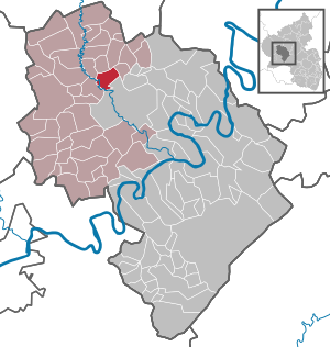
| Location of the local community Plein in the district of Bernkastel-Wittlich | ||
  |
||

Plein is a municipality in the district of Bernkastel-Wittlich in Rhineland-Palatinate . It belongs to the Verbandsgemeinde Wittlich-Land .
history
Plein lies between the volcanic and Moselle Eifel on the northern edge of the Wittlich valley . The village is bordered by Lieser , Lambach and Otterbachtal as well as the Seibertsgraben.
The first written mention of Plein (Plyn) in a document in the archives of the Princes of Metternich, No. 553, dated November 27, 1288. This document is now in the Prague State Central Archives and is available to the local community as a certified copy of the missing original Certificate before.
Plein and Ankes (first called Unkenstein in 1715) belonged to the Electorate of Trier for many centuries, whose archbishops gave them regional rulers a number of times: z. B. 1330 to the Lords of Esch , 1476 to Johann von Orwich called Plieck. The counts of the Manderscheider Niederburg had jurisdiction until the end of the feudal period.
With the French Revolution and its wars of conquest at the turn of the 19th century, Plein came under French government. After the fall of Napoleonic rule in 1815, our region was assigned to the Kingdom of Prussia after the Congress of Vienna. From 1816 Plein belonged to the Grand Duchy of Lower Rhine , from 1820 to the Prussian Rhine Province .
With the creation of the new federal state on December 1, 1946, Plein came back to the Wittlich-Land office in the Wittlich district and, until its dissolution in 1999, to the Trier administrative district. Since the local government reform in 1969, the local community has belonged to the Bernkastel-Wittlich district and the Wittlich-Land association.
politics
Municipal council
The municipal council in Plein consists of twelve council members, who were elected in a majority vote in the local elections in Rhineland-Palatinate on May 26, 2019 , and the honorary local mayor as chairman.
coat of arms
|
|
Blazon : "Under a silver shield head with three black shells (2/1) is the silver Plein Viaduct with four pillars in a red field above a golden serpent winding from left to right." |
| Reasons for the coat of arms: The mussels are so-called scallops . The pilgrims who walked the Way of St. James wore them as a sign of identification. One of the many Way of St. James led past Plein. |
Culture and sights

The Maare-Mosel-Radweg leads on the former railway line over a length of 55 kilometers over the Plein Viaduct and through three tunnels. Plein has hiking trails and a connection to the Eifelsteig.
At the southern entrance to the village is the Lady Chapel from the 17th century.
In the Liesertal the wayside chapel on the Unkenstein with the scallops on the lintel reminds of the submerged village of Ankast; the Jakobus pilgrimage path from the Eifel via Klausen, Trier-Sankt Matthias to Santiago de Compostela in northern Spain, which was already known in the Middle Ages , passes here.
Also worth seeing are the St. James cross from 1749 and the subsidiary church St. James from 1825.
The former Plein train station has been renovated and restored down to the last detail. It is the only station on the Maare-Moselle route that has largely been preserved true to the original and is a monument from the period of industrialization.
See also:
Web links
- Website of the local community Plein
- Link catalog on the topic of Plein at curlie.org (formerly DMOZ )
- To search for cultural assets of the local community Plein in the database of cultural assets in the Trier region .
Individual evidence
- ↑ State Statistical Office of Rhineland-Palatinate - population status 2019, districts, communities, association communities ( help on this ).
- ^ The history of the local parish Plein. Municipality of Plein, accessed December 14, 2018 .
- ^ The Regional Returning Officer Rhineland-Palatinate: Local elections 2019, city and municipal council elections

Altrich | Arenrath | Bausendorf | Brat | Mountain light | Mountain hamlet | Bernkastel-Kues | Bettenfeld | Binsfeld | Brauneberg | Wide | Break | Büdlich | Castle (Mosel) | Castles | Burtscheid | Deuselbach | Throne corners | Diefenbach | Dierfeld | Dierscheid | Dodenburg | Three | Corner field | Eisenschmitt | Enkirch | Earth | Esch | Etgert | River stream | Gielert | Gipperath | Gladbach | Gornhausen | Graach an der Mosel | Gräfendhron | Greimerath | Großlittgen | Hasborn | Heckenmünster | Heidenburg | Heidweiler | Hetzerath | Hilscheid | Hochscheid | Hontheim | Horath | Hupperath | Immert | Irmenach | Karl | Kesten | Kinderbeuern | Kinheim | Klausen | Kleinich | Coming | Kröv | Landscheid | Laufeld | Readers | Longkamp | Losnich | Lötzbeuren | Lückenburg | Malborn | Manderscheid | Maring-Noviand | Meerfeld | Merschbach | Minority | Minheim | Monzelfeld | Morbach | Mülheim an der Mosel | Musweiler | Neumagen-Dhron | Neunkirchen | Niederöfflingen | Niederscheidweiler | Niersbach | Oberöfflingen | Oberscheidweiler | Osann-Monzel | Pantenburg | Piesport | Plates | Plein | Reil | Rivenich | Rorodt | Salmtal | Schladt | Schoenberg | Schwarzenborn | Sehlem | Starkenburg | Talling | Thalfang | Traben-Trarbach | Ürzig | Veldenz | Wallscheid | Willwerscheid | Wintrich | Wittlich | Zeltingen-Rachtig