
Altrich
| coat of arms | Germany map | |
|---|---|---|

|
Coordinates: 49 ° 57 ' N , 6 ° 55' E |
|
| Basic data | ||
| State : | Rhineland-Palatinate | |
| County : | Bernkastel-Wittlich | |
| Association municipality : | Wittlich-Land | |
| Height : | 180 m above sea level NHN | |
| Area : | 16.25 km 2 | |
| Residents: | 1709 (Dec. 31, 2019) | |
| Population density : | 105 inhabitants per km 2 | |
| Postal code : | 54518 | |
| Area code : | 06571 | |
| License plate : | WIL, BKS | |
| Community key : | 07 2 31 001 | |
| LOCODE : | DE 2AN | |
| Community structure: | 2 districts | |
| Association administration address: | Kurfürstenstrasse 1 54516 Wittlich |
|
| Website : | ||
| Mayoress : | Sylvia Stoffel candlestick | |
| Location of the local community Altrich in the district of Bernkastel-Wittlich | ||
  |
||

Altrich is a municipality in the district of Bernkastel-Wittlich in Rhineland-Palatinate . It belongs to the Verbandsgemeinde Wittlich-Land .
geography
Altrich is about four kilometers south of the district town of Wittlich . The district of Büscheid as well as the residential areas Haardt, Kirchhof, Neuenhof, Bahnwärterhaus Sommerkopf and Villa Altrich belong to Altrich.
history
Altrich was first documented in the year 952, when the Archbishop of Trier Ruotbert a "Wido" at the Lieser and Altrich country verlehnte to derive Wingerten to make. In this document the place was called "Altreie". The neighboring town of Wittlich was first mentioned in documents over a hundred years later, in 1065. In a statement from the Koblenz State Main Archives , reference is made to a possibly even older mention of the place. In the so-called " Echternach Chronicle", which the monk Theodoric wrote down in 1192, Altrich is dated to the year 636 under the name "Alta Regia".
Altrich belonged to the Electorate of Trier until the end of the 18th century and with the places Büscheid, Haardt and Kirchhof formed a separate judicial district within the Wittlich office . According to a wisdom from 1444, the dinghouse of the high court of the Wittlich office was also located in what is now the municipality: "In the arbor in front of the large barn at Kirchhof bei Altrich".
After the Left Bank of the Rhine was taken by French revolutionary troops (1794) and integrated into the First French Republic , Altrich belonged to the canton of Wittlich in the Saardepartement from 1798 to 1814 . At the Congress of Vienna (1815) the region was assigned to the Kingdom of Prussia . From 1816 on, Altrich belonged to the newly formed Wittlich district in the Trier administrative district , which was part of the Rhine Province from 1822 to 1946 .
The parish church is dedicated to St. Consecrated to Andreas . Andreasstraße owes its name to her.
Since 1946 the place has belonged to the then newly formed state of Rhineland-Palatinate .
- Population development
The development of the population of Altrich, the values from 1871 to 1987 are based on censuses:
|
|
politics
Municipal council
The municipal council in Altrich consists of 16 council members, who were elected in a personalized proportional representation in the local elections on May 26, 2019 , and the honorary local mayor as chairman.
The distribution of seats in the municipal council:
| choice | SPD | CDU | WGR | total |
|---|---|---|---|---|
| 2019 | - | 7th | 9 | 16 seats |
| 2014 | - | 4th | 12 | 16 seats |
| 2009 | 2 | 5 | 9 | 16 seats |
| 2004 | 5 | 5 | 6th | 16 seats |
coat of arms
|
|
Blazon : "Shield red and white split, in front a white St. Andrew's cross, behind 2 (2: 1) red balls."
With approval from 1971, Altrich received the right to use its own coat of arms. |
| Justification of the coat of arms: The St. Andrew's cross in the front half of the shield stands as a symbol for the church patron Saint Andrew shown in the old court seal, handed down in 1764 . The rear half of the shield is reminiscent of a knight family named after Altrich, which can be traced back to the 14th century. The colors red and white indicate that it was part of the Electorate of Trier . |
Attractions
- Roman wall remains at Neuenhof (outside Altrich in the direction of Klausen )
- the "Cusanus columns" from the former parish church, now in the parish garden at Andreasstrasse 31
- the "thick oak" - a natural monument around 300 years old in the south-west of the village (extension of the street Schneidkaul)
See also:
Economy and Infrastructure
The local community has a kindergarten, a single elementary school and a multi-purpose area with a gym.
The nearest train station is Wittlich Hbf on the Moselle route . The construction of a train stop in Altrich is also planned.
photos

Parish Church of St. Andrew

Parish Church of St. Andrew

Parish Church of St. Andrew

Cusanus columns
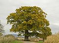
Old oak (thick oak)

Old oak (thick oak)

Surroundings of Altrich

Surroundings of Altrich


.JPG)
literature
- Literature about Altrich in the Rhineland-Palatinate State Bibliography
Web links
- Website of the local community Altrich
- Link catalog on the topic of Altrich at curlie.org (formerly DMOZ )
Individual evidence
- ↑ a b State Statistical Office of Rhineland-Palatinate - population status 2019, districts, municipalities, association communities ( help on this ).
- ↑ State Statistical Office Rhineland-Palatinate (ed.): Official directory of the municipalities and parts of the municipality. Status: January 2018 [ Version 2020 is available. ] . S. 57 (PDF; 2.2 MB).
- ^ Heinrich Beyer : Mittelrheinisches Urkundenbuch , Volume I, Coblenz: Hölscher, 1860, document 193
- ↑ Statement from the State Main Archives Koblenz ( Memento from July 19, 2011 in the Internet Archive )
- ^ Wilhelm Fabricius : Explanations of the historical atlas of the Rhine province, Volume 2: The map of 1789. Bonn, Hermann Behrend, 1898, p. 129, 187
- ↑ Andreasstraße in Altrich from the SWR Landesschau Rheinland-Pfalz accessed on April 14, 2014.
- ↑ State Statistical Office Rhineland-Palatinate - regional data
- ^ The Regional Returning Officer Rhineland-Palatinate: Local elections 2019, city and municipal council elections
- ^ Association meeting, 55th meeting. (PDF; 8.52 MB) In: TOP 3. SPNV Nord , p. 6 , accessed on November 30, 2018 .

Altrich | Arenrath | Bausendorf | Brat | Mountain light | Mountain hamlet | Bernkastel-Kues | Bettenfeld | Binsfeld | Brauneberg | Wide | Break | Büdlich | Castle (Mosel) | Castles | Burtscheid | Deuselbach | Throne corners | Diefenbach | Dierfeld | Dierscheid | Dodenburg | Three | Corner field | Eisenschmitt | Enkirch | Earth | Esch | Etgert | River stream | Gielert | Gipperath | Gladbach | Gornhausen | Graach an der Mosel | Gräfendhron | Greimerath | Großlittgen | Hasborn | Heckenmünster | Heidenburg | Heidweiler | Hetzerath | Hilscheid | Hochscheid | Hontheim | Horath | Hupperath | Immert | Irmenach | Karl | Kesten | Kinderbeuern | Kinheim | Klausen | Kleinich | Coming | Kröv | Landscheid | Laufeld | Readers | Longkamp | Losnich | Lötzbeuren | Lückenburg | Malborn | Manderscheid | Maring-Noviand | Meerfeld | Merschbach | Minority | Minheim | Monzelfeld | Morbach | Mülheim an der Mosel | Musweiler | Neumagen-Dhron | Neunkirchen | Niederöfflingen | Niederscheidweiler | Niersbach | Oberöfflingen | Oberscheidweiler | Osann-Monzel | Pantenburg | Piesport | Plates | Plein | Reil | Rivenich | Rorodt | Salmtal | Schladt | Schoenberg | Schwarzenborn | Sehlem | Starkenburg | Talling | Thalfang | Traben-Trarbach | Ürzig | Veldenz | Wallscheid | Willwerscheid | Wintrich | Wittlich | Zeltingen-Rachtig