
Schladt
| coat of arms | Germany map | |
|---|---|---|

|
Coordinates: 50 ° 2 ′ N , 6 ° 51 ′ E |
|
| Basic data | ||
| State : | Rhineland-Palatinate | |
| County : | Bernkastel-Wittlich | |
| Association municipality : | Wittlich-Land | |
| Height : | 330 m above sea level NHN | |
| Area : | 4.96 km 2 | |
| Residents: | 137 (Dec. 31, 2019) | |
| Population density : | 28 inhabitants per km 2 | |
| Postal code : | 54534 | |
| Area code : | 06575 | |
| License plate : | WIL, BKS | |
| Community key : | 07 2 31 114 | |
| Community structure: | 3 districts | |
| Association administration address: | Kurfürstenstrasse 1 54516 Wittlich |
|
| Website : | ||
| Local Mayor : | Rainer Ernst | |
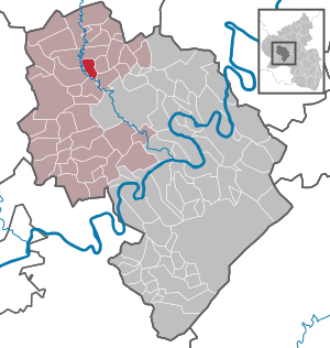
| Location of the local community Schladt in the district of Bernkastel-Wittlich | ||
  |
||

Schladt is a municipality in the Bernkastel-Wittlich district in Rhineland-Palatinate . It belongs to the Verbandsgemeinde Wittlich-Land .
geography

The village is located in the Eifel east of the Lieser in a natural landscape known as Schladter Switzerland . Neighboring towns are Gipperath , Plein , Minderlittgen , Großlittgen and Karl . The next largest city is Wittlich , about six kilometers to the southeast.
Schladt includes the Schladtermühle residential area and the southern part of the Brühlweiler hamlet . The northern part of the hamlet belongs to the local community of Oberöfflingen .
history
From 1794 Schladt was under French rule, in 1815 the place was assigned to the Kingdom of Prussia at the Congress of Vienna . Since 1946 it has been part of the then newly formed state of Rhineland-Palatinate .
Municipal council
The municipal council in Schladt consists of six council members, who were elected by a majority vote in the local elections on May 26, 2019 , and the honorary local mayor as chairman.
Culture and sights
- 600 year old village oak with a circumference of 5.20 m
- Chapel in the town center
Economy and Infrastructure
Federal motorway 60 runs to the south and federal motorway 1 to the east . In Wittlich there is a train station on the Moselle line .
Web links
Individual evidence
- ↑ State Statistical Office of Rhineland-Palatinate - population status 2019, districts, communities, association communities ( help on this ).
- ↑ State Statistical Office Rhineland-Palatinate (ed.): Official directory of the municipalities and parts of the municipality. Status: January 2018 [ Version 2020 is available. ] . S. 58 (PDF; 2.2 MB).
- ^ The Regional Returning Officer Rhineland-Palatinate: Local elections 2019, city and municipal council elections

Altrich | Arenrath | Bausendorf | Brat | Mountain light | Mountain hamlet | Bernkastel-Kues | Bettenfeld | Binsfeld | Brauneberg | Wide | Break | Büdlich | Castle (Mosel) | Castles | Burtscheid | Deuselbach | Throne corners | Diefenbach | Dierfeld | Dierscheid | Dodenburg | Three | Corner field | Eisenschmitt | Enkirch | Earth | Esch | Etgert | River stream | Gielert | Gipperath | Gladbach | Gornhausen | Graach an der Mosel | Gräfendhron | Greimerath | Großlittgen | Hasborn | Heckenmünster | Heidenburg | Heidweiler | Hetzerath | Hilscheid | Hochscheid | Hontheim | Horath | Hupperath | Immert | Irmenach | Karl | Kesten | Kinderbeuern | Kinheim | Klausen | Kleinich | Coming | Kröv | Landscheid | Laufeld | Readers | Longkamp | Losnich | Lötzbeuren | Lückenburg | Malborn | Manderscheid | Maring-Noviand | Meerfeld | Merschbach | Minority | Minheim | Monzelfeld | Morbach | Mülheim an der Mosel | Musweiler | Neumagen-Dhron | Neunkirchen | Niederöfflingen | Niederscheidweiler | Niersbach | Oberöfflingen | Oberscheidweiler | Osann-Monzel | Pantenburg | Piesport | Plates | Plein | Reil | Rivenich | Rorodt | Salmtal | Schladt | Schoenberg | Schwarzenborn | Sehlem | Starkenburg | Talling | Thalfang | Traben-Trarbach | Ürzig | Veldenz | Wallscheid | Willwerscheid | Wintrich | Wittlich | Zeltingen-Rachtig