
Wide
| coat of arms | Germany map | |
|---|---|---|

|
Coordinates: 49 ° 47 ' N , 6 ° 54' E |
|
| Basic data | ||
| State : | Rhineland-Palatinate | |
| County : | Bernkastel-Wittlich | |
| Association municipality : | Thalfang at the Erbeskopf | |
| Height : | 400 m above sea level NHN | |
| Area : | 4 km 2 | |
| Residents: | 290 (Dec. 31, 2019) | |
| Population density : | 73 inhabitants per km 2 | |
| Postal code : | 54426 | |
| Area code : | 06509 | |
| License plate : | WIL, BKS | |
| Community key : | 07 2 31 202 | |
| LOCODE : | DE RTY | |
| Association administration address: | Saarstrasse 7 54424 Thalfang |
|
| Website : | ||
| Local Mayor : | Christine Paulussen | |
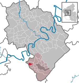
| Location of the local community Breit in the district of Bernkastel-Wittlich | ||
  |
||


Breit is a municipality in the district of Bernkastel-Wittlich in Rhineland-Palatinate . It belongs to the Verbandsgemeinde Thalfang am Erbeskopf .
Geographical location
The place is in the Hunsrück on a hilltop about 400 m above sea level and thus about 150 m above the valley floor of the Kleine Dhron .
history
The local community Breit appears for the first time in the name of "Conrad von Breit" in a piece of the Abbey of St. Maximin from the beginning of the 13th century .
Until the end of the 18th century, Breit belonged to the Electoral Trier office of Maximin and was assigned to the Detzem High Court . After the French Revolution in 1794, the Left Bank of the Rhine, and with it Breit, was taken over by France . From 1798 to 1814 the place belonged to the canton Büdlich in the Saardepartement . By law of March 26, 1798, the French repealed feudal rights in the region. After French rule, the place came to the Kingdom of Prussia in 1815 . Since 1946 it has been part of the state of Rhineland-Palatinate. Since the Rhineland-Palatinate administrative reform of 1969, Breit has belonged to the Verbandsgemeinde Thalfang am Erbeskopf in the district of Bernkastel-Wittlich . Until then it belonged to the office of Klüsserath , which was dissolved in the course of the administrative reform.
- Population development
The development of the population of Breit, the values from 1871 to 1987 are based on censuses:
|
|
politics
Municipal council
The council in broad consists of six council members, who in the local elections on May 26, 2019 in a majority vote were elected, and the honorary mayor as chairman.
mayor
Christine Paulußen has been the local mayor since November 2019.
Culture and sights
The ball tree, an oak about 200 years old, stands in width ; the local sports club is FC Büdlich-Breit-Naurath . There is also a music association , a church choir , a theater association and the support association of the Breit volunteer fire brigade .
The Ausoniusweg leads past Breit . A hiking route that leads from Trier to Bingen and is named after the Roman poet and civil servant Decimus Magnus Ausonius , who traveled and described the area between 365 and 368 AD.
See also:
Economy and Infrastructure
Breit is structured as a cluster village .
The Mehring ( A1 ) motorway junction at a distance of around 8 km provides supraregional transport links . The next train station is the main train station in Trier , which can be reached after approx. 25 km from Breit.
Web links
- Internet presence of the local community Breit
- Link catalog on the subject of wide at curlie.org (formerly DMOZ )
Individual evidence
- ↑ State Statistical Office of Rhineland-Palatinate - population status 2019, districts, communities, association communities ( help on this ).
- ↑ State Statistical Office Rhineland-Palatinate - regional data
- ^ The Regional Returning Officer Rhineland-Palatinate: Local elections 2019, city and municipal council elections
Mountain light | Wide | Büdlich | Burtscheid | Deuselbach | Throne corners | Etgert | Gielert | Gräfendhron | Heidenburg | Hilscheid | Horath | Immert | Lückenburg | Malborn | Merschbach | Neunkirchen | Rorodt | Schoenberg | Talling | Thalfang

Altrich | Arenrath | Bausendorf | Brat | Mountain light | Mountain hamlet | Bernkastel-Kues | Bettenfeld | Binsfeld | Brauneberg | Wide | Break | Büdlich | Castle (Mosel) | Castles | Burtscheid | Deuselbach | Throne corners | Diefenbach | Dierfeld | Dierscheid | Dodenburg | Three | Corner field | Eisenschmitt | Enkirch | Earth | Esch | Etgert | River stream | Gielert | Gipperath | Gladbach | Gornhausen | Graach an der Mosel | Gräfendhron | Greimerath | Großlittgen | Hasborn | Heckenmünster | Heidenburg | Heidweiler | Hetzerath | Hilscheid | Hochscheid | Hontheim | Horath | Hupperath | Immert | Irmenach | Karl | Kesten | Kinderbeuern | Kinheim | Klausen | Kleinich | Coming | Kröv | Landscheid | Laufeld | Readers | Longkamp | Losnich | Lötzbeuren | Lückenburg | Malborn | Manderscheid | Maring-Noviand | Meerfeld | Merschbach | Minority | Minheim | Monzelfeld | Morbach | Mülheim an der Mosel | Musweiler | Neumagen-Dhron | Neunkirchen | Niederöfflingen | Niederscheidweiler | Niersbach | Oberöfflingen | Oberscheidweiler | Osann-Monzel | Pantenburg | Piesport | Plates | Plein | Reil | Rivenich | Rorodt | Salmtal | Schladt | Schoenberg | Schwarzenborn | Sehlem | Starkenburg | Talling | Thalfang | Traben-Trarbach | Ürzig | Veldenz | Wallscheid | Willwerscheid | Wintrich | Wittlich | Zeltingen-Rachtig