
Maare-Moselle cycle path
| Maare-Moselle cycle path | |
|---|---|

|
|
| overall length | 58 km |
| location | Eifel , Moselle / Rhineland-Palatinate |
| map | |
| Link to map and elevation profile | |
| Starting point | Down |
| Target point | Bernkastel-Kues |
| Places along the way | Mehren , Schalkenmehren , Gillenfeld , Eckfeld , Wallscheid , Laufeld , Hasborn , Wittlich , Wengerohr , Platten , Maring-Noviand , Lieser |
| Flooring | paved throughout |
| Height difference | Start 390 m , end 117 m +161 m up / −449 m down |
| difficulty | approx. 2.5%, on two climbs (railway line) |
| Traffic volume | former railway line, roads rarely with little traffic |
| Connection to | Eifel-Ardennes bike path , Kosmosradweg , mineral springs route , bike path Wittlich valley , Mosel bike path |
| Website URL | www.maare-moselradweg.de |
The Maare-Mosel-Radweg is a cycle path that connects Daun in the Vulkaneifel with the Moselle valley via the former secondary railway lines Daun-Wengerohr and Wengerohr-Bernkastel-Kues . On the old railway line it goes with a maximum gradient of 3% over viaducts, bridges, through tunnels and the Eifel forests down into the Moselle valley. The part of the Eifel , shaped by volcanism and the maars , is being replaced by the cultural landscape of viticulture on the Moselle , which is reached near the village of Lieser . The rest of the way to Bernkastel-Kues, the route follows the Moselle cycle path . The route partly follows the course of the Moselle tributaries Alf and Lieser . The continuously paved route is suitable for recreational cyclists and families with children. The long slopes require a certain amount of practice from inline skaters. The maximum gradient is also 3% in the opposite direction. The Daun – Moselle valley route is uniformly marked in both directions with the cycle path logo. An almost flat, approx. 11 km long children's cycle path has been created between Daun and Gillenfeld . You can find out more about the country and its people on the cycle adventure loops that branch off from the main route. Together with the mineral springs route connects the Maare-Moselle bicycle route, the rivers Ahr and Moselle on a bike route with only moderate inclines.
Route Daun - Bernkastel-Kues
Daun - Gillenfeld
(Length: 11 km; with an incline of +68 meters and a decline of −73 meters).
The route starts in the district and spa town of Daun and leads on the former railway line over the Daun Viaduct , which allows a view over Daun from a height of 28 m. The route leads slightly uphill through the forest until you reach the 560 m long, illuminated “Großes Schlitzohr” railway tunnel. For bats, a false ceiling was put into the tunnel built in 1908. Here the apex of the route is exceeded at 480 m , after a continuous ascent with an average of 2.5% gradient over a length of 3.5 km. The route now leads over Mehren and Schalkenmehren with a slight incline to Gillenfeld . On the route, five so-called bike adventure loops branch off and open up the sights around Mehren.
- The “Mehren” loop with a length of 3 km begins at the rest area behind the “Großes Schlitzohr” tunnel, leads around Mehren, and comes back to the main path at the Sangweiher nature reserve.
- The loop "Vulcano Infoplattform Steineberg" is 16 km long and leads mainly uphill from Mehren via Steiningen to Steineberg to the 28 m high "Vulcano Infoplattform". From there you have a panoramic view of the volcanic landscape of the Eifel. At Gillenfeld the loop leads back to the main path.
- The loop “Mürmes – Saxler – Ellscheid” has a length of 10 km. The Mürmes nature reserve is a marsh area between the towns of Ellscheid , Saxler and Mehren.
- The “Brockscheid – Holzmaar” loop with a length of 6.5 km leaves the main route at the Sangweiher nature reserve and climbs slightly to Brockscheid , where one of the few bell- makers in Germany is still located. The way back leads over the Holzmaar near Gillenfeld, where the main route is reached again.
- The loop “Strohn – Mückeln” is 12 km long. It leaves the main route in Gillenfeld. It leads past the 120-ton lava bomb to Strohn and then with a steep ascent through “Strohner Schweiz” to Mückeln . From there it goes back to Gillenfeld on the main path. The so-called "Strohner Schweiz" is a breakthrough valley of the Alf river. The Alf created a new bed here using the 12,000 year old Strohn lava flow, which blocked the original river bed. The Vulkanhaus in Strohn invites you to visit.
The Pulvermaar lies near Gillenfeld ; it is the deepest natural lake in Germany after Lake Constance and the foothills of the Alps.
Gillenfeld – Hasborn
(Length: 16 km; with +85 meters of ascent and −102 meters of descent).
Between Gillenfeld and Eckfeld there is a slight incline to overcome before the route leads steadily downhill into the Moselle valley. Before Hasborn , the Eifel towns of Wallscheid and Laufeld are passed. On this section, three more adventure loops lead into the surrounding area.
- The adventure loop "Kloster Buchholz" is 9 km long and leaves the main route at Eckfeld. The loop initially leads to the former Buchholz monastery . Past the station path it goes towards Pantenburg . After a steep descent, the L16 is crossed, on the in about four kilometers, after a climb from the Liesertal , Manderscheid be reached. The wheel loop, however, leads back to the main route via Pantenburg and Wallscheid.
- The “Grafschaft” adventure loop leads back on the main route for 6 km from Laufeld via Oberöfflingen and Niederöfflingen shortly before Hasborn. The toy and doll museum in Laufeld is passed.
- The “Greimerath” adventure loop with a length of 3 km leaves the main route at the motorway bridge immediately behind Hasborn and leads over the main street of Greimerath . Past the baroque parish church of St. Georg, which is well worth seeing, the loop then returns to the main route.
Hasborn – Wittlich
(Length: 11 km; with +4 meters of ascent and −209 meters of descent).
From Hasborn to Wittlich bus station , the route descends with an average gradient of 2.5%. Directly after the former train station in Plein , approx. 5 km behind Hasborn, the cycle path leads through the 585 meter long Plein tunnel. Then it goes through deciduous and mixed forests further down to Wittlich. The cycle path leads from the rather rough Vulkaneifel down into the Wittlich valley . The route leads past the vineyards to the town of Wittlich. A loop is signposted here, which leads through the old town under the motto “In the middle instead of past it”. In the old town of Wittlich, you can visit the city gallery for modern art in the old town hall. In addition, the city offers other sights with the market square, the former synagogue and the Roman villa.
On this section of the Maare-Mosel-Radweg further structures of the former railway line are passed:
- Plein Viaduct, length 98 meters, height above valley 31 meters
- Unkenstein tunnel, length 140 meters
- Grünewald tunnel, length 124 meters
Other bike adventure loops also lead into the surrounding area:
- “Descent loop” (16 km): From the Plein train station, the descent leads to the Liesertal and then along the Lieser to the main route in Wittlich.
- “Mill ride loop” (32 km): Drive through the historic old town of Wittlich to Bergweiler with the Fintenkapelle and the village museum. Then after break with his oil mill and water castle . Finally, via the Dreiser Schloss to Wittlich.
- “Pilgrimage loop” (24 km): Drive from Wittlich towards Altrich and continue on the Roman road to Klausen with its pilgrimage church of St. Maria . From here the route follows the pilgrimage route via Osann-Monzel to Platten . The loop then uses part of the main route before it leads through Wengerohr to the St. Paul Mission House. Then the loop ends on the main route of the Maare-Mosel cycle path.
Wittlich-Lieser
(Length: 15 km; with +4 meters of ascent and -65 meters of descent).
From Wittlich the cycle route continues to the Wittlich district of Wengerohr , where Wittlich main station is located on the Moselle route Koblenz-Trier. The route continues downwards via Platten and Maring-Noviand to Lieser on the Moselle.
On this section, too, cycle adventure loops lead into the surrounding area:
- "Tobacco loop" (18 km): This loop starts in Wittlich, follows the Maare-Mosel cycle path to Platten and then leads through the fields to Wengerohr and Bombogen . After circumnavigating Neuerburg , the route leads back to Wittlich via Lüxem . There are tobacco fields and tobacco barns along the route .
- "Wine Tour Loop" (44 km): This loop leads from Platten via Osann-Monzel and Klausen to Minheim on the Moselle cycle path . Here on via Kesten to Lieser. From there via Maring-Noviand back to Platten. The loop leads through the vineyards of the Michelsberg area , which belongs to the Middle Moselle, and the educational wine trail near Osann-Monzel.
Lieser-Bernkastel-Kues
The last five kilometers after Lieser the route leads along the banks of the Moselle on the Moselle cycle path to Bernkastel-Kues .
Landscape and culture

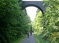
Railway viaduct in Daun
Old route near Daun

Lava bomb near Strohn

Ruins of the Lower Castle Manderscheid

The Spitzhäuschen in Bernkastel
.jpg)


The landscape through which the Maare-Moselle cycle path leads from the starting point is characterized by its volcanic character. 2.5 km to 3.5 km south-east of the starting point Daun are the so-called Dauner Maars, three directly adjacent maars that are only separated by their tuff walls: the Gemündener Maar , the Weinfelder Maar and the Schalkenmehrener Maar . The district and spa town of Daun is dominated by the Daun Castle and also houses the Eifel volcano museum . After Schalkenmehren with the famous Schalkenmehrener Maar, the former railway line and with it the cycle path follow the Moselle tributary Alf to the level of Gillenfeld, where the deep powder maar can be found. From here, the Strohn volcano house , the 120-ton lava bomb and the “Strohner Schweiz” can be reached via the “Strohn - Mückeln” bike adventure route . Past the Holzmaar , the route then leads to Pantenburg , from where a detour to the Eifel town of Manderscheid with its castles is possible. One of the few still existing bell foundries can be visited on the “Brockscheid - Holzmaar” cycle adventure loop. The long tunnels, viaducts and other remnants of the former railway line are interesting for railway enthusiasts. Before Wittlich the landscape changes and the route leads into the wine-growing region of the Moselle. The district town of Wittlich is located on the Lieser in a side valley of the Moselle on the northern edge of the Wittlich depression . The city offers a historic old town and a medium-sized center . After Wittlich the route leads to the Moselle with its vineyards and ends in Bernkastel-Kues with its medieval townscape.
Attractions
- Daun : Daun wildlife and adventure park; Daun Castle ; Catholic parish church of St. Nikolas ; Daun volcano museum ; Railway viaduct from 1909; the maars Gemündener Maar , Weinfelder Maar and Schalkenmehrener Maar ( see also: List of cultural monuments in Daun ).
- Brockscheid : bell foundry .
- Gillenfeld : The Pulvermaar is not far from Gillenfeld and is the deepest natural lake in Germany after Lake Constance and the pre-Alpine lakes. In summer there is a lot of bathing activity here. Together with the Holzmaar it forms the Gillenfelder Maare.
- Strohn : lava bomb; Volcano house. The so-called "Strohner Schweiz" is a breakthrough valley of the Alf river. The Alf created a new bed here using the 12,000 year old Strohn lava flow, which blocked the original river bed.
- Laufeld : Doll and toy museum
- Hasborn : St. Rochus Chapel; Hasborner Sauerbrunnen .
- Wittlich : old town with market square; Old town hall with municipal gallery for modern art ; former synagogue ; Roman villa ( see also: List of cultural monuments in Wittlich ).
- Bernkastel-Kues : Worth seeing in the Bernkastel district is the medieval market square with its gabled half-timbered houses from the 17th century, among which the narrow pointed house from 1416 stands out particularly; the Renaissance town hall from 1608; the Landshut castle ruins above the district. ( See also: List of cultural monuments in Bernkastel-Kues ). The city in its current form was created on April 1, 1905 through the merger of the city of Bernkastel with the wine-growing village of Kues opposite.

Train and bus connections
The Hauptbahnhof Wittlich lies on the Mosel route Koblenz - Trier and is operated by the hour. Rail buses and reconditioned passenger trains of the Vulkan-Eifel-Bahn (VEB) have been running on the Kaisersesch - Daun - Gerolstein route of the former Eifelquerbahn since 2000 . Operation every two hours is limited to the season from May to October. There are stops on this route in the towns of Dockweiler and Rengen. However, rail traffic was discontinued in 2012.
The “ Regioradler Vulkaneifel ” RegioLinie 500 bus runs between Cochem on the Moselle and Gerolstein in the Vulkaneifel and also connects Ulmen and Daun on the way, while the RegioLinie 300 as a cyclist bus between Bernkastel , Wittlich and Daun runs along the Maare-Mosel cycle path served. These buses run daily from April 1st to November 1st and have space for 22 bicycles.
Connecting cycle paths
The Maare-Moselle cycle path connects to the Ahr cycle path via the mineral spring route , which is reached near Ahrdorf . It is connected to the Kylltal cycle path via the Kalkeifel cycle path . This is reached at Hillesheim-Bolsdorf . When you reach the Moselle valley, the Moselle cycle path is connected to Lieser . With the starting point Daun, the themed route Kosmosradweg and the international Eifel-Ardennen-Radweg are also connected. With it, the Maare-Moselle cycle path is extended in an east-west direction. The Wittlich Senke cycle path to Schweich starts in Wittlich and provides another connection to the Moselle valley. See also:
literature
- ADFC regional map Eifel / Mosel , 1: 75,000. Bielefelder Verlag, 1st edition 2006. ISBN 3-87073-391-8
- Cycle Atlas Cycle Atlas "South Eifel" - between the Ardennes and the Vulkaneifel , 1: 75,000. Esterbauer publishing house. ISBN 978-3-85000-269-1
- Rivers and railway lines Eifel , 1: 50,000. Verlag Esterbauer, 2nd edition 2018. ISBN 978-3-85000-682-8
- Werner P. D'hein : Nature and culture guide Vulkanlandeifel. With 26 stations on the "German Volcano Road". Gaasterland-Verlag, Düsseldorf 2006, ISBN 3-935873-15-8
Web links
- Map and GPS data from Eifel Tourismus GmbH
- Elevation profile, GPS download and pictures on bahntrassenradwege.de
- Children's bike path
swell
- Radwanderland.de , accessed November 2011
Individual evidence
- ↑ The Maare-Mosel-Radweg introduces itself , at www.maare-moselradweg.de, accessed on June 9, 2018
- ↑ The children's cycle path in the Vulkaneifel , at www.gesundland-vulkaneifel.de, accessed on June 9, 2018
- ^ Vulkanhaus Strohn with lava bomb , at www.vulkanhaus-strohn.de, accessed on June 9, 2018
- ↑ RegioRadler Vulkaneifel , on www.regioradler.de, accessed on June 9, 2018
- ↑ RegioRadler MaareMosel , at www.regioradler.de, accessed on June 9, 2018
Coordinates: 50 ° 11 ′ 52.2 " N , 6 ° 50 ′ 7.2" E