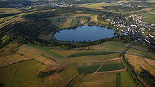
Schalkenmehrener Maar
The Schalkenmehrener Maar is a maar around three kilometers southeast of the town of Daun in the Eifel . The village of Schalkenmehren is immediately adjacent .
geography
It belongs to the so-called Dauner Maars (or to the Dauner (Maar) group ), even if all three maars are in the area of Schalkenmehren, and is a double maar, consisting of the western maar lake and the eastern dry maar. Both were formed around 10,500 years ago after a volcanic steam explosion . The lake in the western part of the maar varies in diameter between 500 and 575 m and is up to 21 m deep. The height of the maar is 420.8 m above sea level. NHN (mean water level). It fills the younger of the two maark basins. The eastern part of the maar is occupied by a raised bog.
flora
From a botanical point of view, three different zones can be identified: The immediate bank area, the flat or low moor in the eastern part and the slopes of the Maarkessel. In addition to the reeds and a. the swamp iris , the white water lily , yellow loosestrife and purple loosestrife and the common pond rush . A mixture of dry grass and forest edge vegetation prevails on the slopes of the Maarkessel . In addition to sand thyme and oregano , there are the creeping hawk , hare and field clover , the wild flat pea , the musk mallow , the cluster bellflower , the yellow hollow tooth , the orange-red hawkweed , meadow and scabiosa knapweed , the pigeons -Sabiose , the woodruff and considerable stocks of the narrow-leaved willowherb . On neophytes are u. a. to observe the many-leaved lupine and the large-flowered glue seed .
See also
literature
- Werner D'hein : Nature and culture guide Vulkanlandeifel. With 26 stations on the "German Volcano Road". Gaasterland-Verlag, Düsseldorf 2006, ISBN 3-935873-15-8 .
Web links
Individual evidence
- ↑ Map service of the landscape information system of the Rhineland-Palatinate nature conservation administration (LANIS map) ( notes )
Coordinates: 50 ° 10 ′ 10 ″ N , 6 ° 51 ′ 29 ″ E


