
Eifelsteig
| Eifelsteig | |
|---|---|
 Eifelsteig signpost |
|
| Data | |
| length | 313 km |
| location | Eifel |
| Markers | Stylized E: blue = sky / maars, green = landscape, yellow = "Eifel gold" (gorse / rape blossom) |
| Starting point |
Kornelimünster 50 ° 43 ′ 41.2 " N , 6 ° 10 ′ 58.3" E |
| Target point |
Trier 49 ° 46 ′ 8.5 ″ N , 6 ° 37 ′ 58.4 ″ E |
| Type | Long-distance hiking trail |
| Height difference | 15,758 m |
| The highest point | Steling (658 m) |
| Lowest point | 132 m |
| season | All year round |
The Eifelsteig is a 313 km long long- distance hiking trail in the Eifel . It leads in 15 stages from 14 to 29 kilometers in length from the Aachen district of Kornelimünster to Trier . During this route he overcomes a total of 15,758 meters of altitude, of which 7,746 meters are ascent and 8,014 meters are descent. It crosses the High Fens , the Rurtal , the Eifel National Park , the Vulkaneifel and the South Eifel . The route runs through the federal states of North Rhine-Westphalia and Rhineland-Palatinate .
The route developed by the Eifelverein was officially opened on April 4, 2009 with an opening hike from Mirbach to Alendorf. Until September 2008, the Eifelsteig marked a circular hiking trail in four stages with start / finish in Blankenheim .
Waymarks
The path is marked with the emblem shown on the right, a stylized E with the blue of the sky and the maars , the green of the landscape and the yellow of the "Eifel gold", the gorse and rape blossom. At junctions, signposts with kilometers and blue tips point out the further course of the Eifelsteig. Side routes, partner routes and access routes have signposts with yellow tips. Exact location information with meters above sea level, UTM coordinates and tourist points complete the signposts.
Stages
| stage | begin | target | Length [km] |
Total length [km] |
Duration [h] |
Altitude [m] |
|---|---|---|---|---|---|---|
| 1 | Kornelimünster | Roetgen | 14th | 14th | 4½ → / ← 3½ | +361; −174 |
| 2 | Roetgen | Monschau | 17th | 31 | 4th | +318; −324 |
| 3 | Monschau | Einruhr | 25th | 56 | 6th | +684; −809 |
| 4th | Einruhr | Gemünd | 21.5 | 78 | 5 | +633; −582 |
| 5 | Gemünd | Steinfeld Monastery | 17.5 | 95 | 6th | +530; −351 |
| 6th | Steinfeld Monastery | Blankenheim | 22.5 | 118 | 6½ | +356; −395 |
| 7th | Blankenheim | Mirbach | 17.5 | 135 | 5 | +404; −412 |
| 8th | Mirbach | Hillesheim | 25.5 | 161 | 6½ | +461; −479 |
| 9 | Hillesheim | Gerolstein | 20th | 181 | 5½ | +491; −563 |
| 10 | Gerolstein | Down | 25th | 206 | 6th | +769; −728 |
| 11 | Down | Manderscheid | 23 | 229 | 6½ | +555; −611 |
| 12 | Manderscheid | Himmerod Monastery | 18th | 247 | 5½ | +515; −582 |
| 13 | Himmerod Monastery | fracture | 20.5 | 267 | 6th | +368; −471 |
| 14th | fracture | cord | 29 | 296 | 8½ | +614; −664 |
| 15th | cord | trier | 18th | 314 | 5 | +687; −689 |
Source: Homepage of the Eifelsteig
Picture gallery

The Kalvarienberg near Alendorf is overcome by the Eifelsteig.
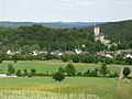
Kerpen Castle (Eifel) , in front on the right the Eifelsteig.

Stage location Bruch , on the right the Eifelsteig with loungers for hikers.

The Eifelsteig near Monschau .


literature
- Ingrid Retterath: OutdoorHandbuch Vol. 226: Germany: Eifelsteig . Conrad Stein Verlag, Welver 2010, ISBN 978-3-86686-310-1 .
- Manfred Böckling: DuMont active: hiking on the Eifelsteig. DuMont Reiseverlag, Ostfildern 2010, ISBN 978-3-7701-8029-5 .
- Eifelsteig from Aachen to Trier. Topographic map 1: 50,000 with hiking and biking trails . State Office for Surveying and Basic Geographic Information Rhineland-Palatinate, Koblenz 2012, ISBN 978-3-89637-405-9 .
- Ulrike Poller u. Wolfgang Todt: Eifelsteig; 330 eventful kilometers; 16 tours from Aachen to Trier . idee media, Neuwied 2010, ISBN 978-3-934342-28-6 .
- Hans-Peter Schmitz: Eifelsteig from Aachen to Trier; Part 1: Aachen-Blankenheim . Eifelverein e. V., Düren 2007, ISBN 978-3-921805-56-5 .
- Hans-Peter Schmitz: Where rock and water accompany you. Eifelsteig Aachen-Trier plus partner routes in North Rhine-Westphalia. 650 km of quality hiking trails, maps & altitude profiles, stopping off & staying overnight, sights, views of the Eifel. Eifelverein e. V., Düren 2010, ISBN 978-3-921805-76-3 .
Web links
- eifelsteig.de - Official Eifelsteig website
- eifelsteig-monschauerland.de - The first four stages in the Monschauer Land (alternative official representation)
- wanderkompass.de - Eifelsteig
- gpsies.com - Map and data of the entire Eifelsteig route
- portal.dnb.de - literature on the Eifelsteig in the catalog of the German National Library
- eifel-und-kunst.de - detailed stage reports and photos