
Wehebachtalsperre
| Wehebachtalsperre | |||||||||
|---|---|---|---|---|---|---|---|---|---|
 |
|||||||||
|
|||||||||
|
|||||||||
| Coordinates | 50 ° 45 '20 " N , 6 ° 20' 27" E | ||||||||
| Data on the structure | |||||||||
| Lock type: | Rock embankment dam | ||||||||
| Construction time: | 1977-1981 | ||||||||
| Height above valley floor: | 45 m | ||||||||
| Height above foundation level : | 49.5 m | ||||||||
| Height of the structure crown: | 255 m | ||||||||
| Building volume: | 750,000 m³ | ||||||||
| Crown length: | 435 m | ||||||||
| Crown width: | 9 m | ||||||||
| Base width: | 168.6 m | ||||||||
| Slope slope on the air side : | 1: 1.5 (bottom) to - 1: 2 (top) | ||||||||
| Slope slope on the water side : | 1: 1.6 | ||||||||
| Power plant output: | 0.053 MW | ||||||||
| Operator: | Eifel-Rur water association | ||||||||
| Data on the reservoir | |||||||||
| Altitude (at congestion destination ) | 251.80 m | ||||||||
| Water surface | 162 ha | ||||||||
| Reservoir length | 4 km | ||||||||
| Storage space | 25.06 hm³ | ||||||||
| Total storage space : | 27.1 million m³ | ||||||||
| Catchment area | 43.5 km³ | ||||||||
| Design flood : | 65 m³ / s | ||||||||

The Wehebach dam is located between the Hürtgenwald in the Düren district and Stolberg (Rhineland) in the Aachen city region in North Rhine-Westphalia . It was put into operation in 1983 for flood protection , drinking water supply and low water elevation . Below the dam, the Wehebach flows further into the Inde and Rur . The dam belongs to the Eifel-Rur Water Association (WVER).
The reservoir
The Wehebachtalsperre reservoir has three arms: in the west the valley of the red Wehebach, to the east that of the Wehebach (also known as the white Wehe) and in the west-east axis the valley of the Thönbach.
The dam
The dam is a rock rubble dam made of slate and greywacke with a bituminous outer seal and an additional bituminous braking zone (bitumen sand) in the core. This was built in to protect against earthquakes . A withdrawal tower with an adjoining tunnel is used to withdraw drinking water. The flood relief is on the right slope. It has a fan-like, 24-meter-wide overflow with a 6-meter-wide chute that goes over the valley flank and ends in the stilling basin . The dam has an inspection passage in the hearth wall on the water side and two berms on the air side .
The drinking water treatment plant is located below the dam.
Tributaries of the Wehebachtalsperre
In addition to the main tributaries Roter Wehebach, Weißer Wehebach, Weberbach and Thönbach, the Wehebachtalsperre is fed by a number of other streams. The graphic arms of the Wehebachtalsperre shows an overview of the reservoir. Referring to the graphic, the Rote Wehebach feeds arm "1", Weißer Wehebach and Weberbach feeds arm "2" and Tönbach feeds arm "3".
Definition of Weißer Wehebach: In vernacular usage and shown on some maps, the upper section of the Wehebach, the section from its source to the confluence with the Wehebachtalsperre, based on the Roten Wehebach, is called the Weißer Wehebach. The Wehebach has a total length of 25,696 meters.


| inflow | Alias | length | receiving water | Barrage arm |
|---|---|---|---|---|
| Red Wehebach | 6,706 m | Wehebach | 1 | |
| Roter Wehebach (II) | 658 m | Rothsiefen | 1 | |
| Rothsiefen | 2,613 m | Roter Wehebach (*) | 1 | |
| Rothsiefen (II) | 1,188 m | Red Wehebach | 1 | |
| Pitfalls | 1,898 m | Red Wehebach | 1 | |
| Pioneering depths | 1,149 m | Red Wehebach | 1 | |
| White Wehebach | Wehebach | 2 | ||
| Huertgenbach | 4,083 m | White Wehebach | 2 | |
| Germetsbach | 1,341 m | White Wehebach | 2 | |
| Mühlenbach | 2,383 m | White Wehebach | 2 | |
| Cherry flavors | 851 m | White Wehebach | 2 | |
| Slate pit | 1,110 m | White Wehebach (*) | 2 | |
| Horse depths | 981 m | White Wehebach | 2 | |
| Stinking depths | 730 m | White Wehebach | 2 | |
| Mosquito bites | 796 m | White Wehebach | 2 | |
| Sleeve depths | 1,523 m | White Wehebach (*) | 2 | |
| Root depths | 635 m | White Wehebach (*) | 2 | |
| Rodsbergsiefen | 748 m | White Wehebach | 2 | |
| Weberbach | Frenkbach | 3,738 m | White Wehebach (*) | 2 |
| Asselbach | 1,365 m | Huertgenbach | 2 | |
| Thönbach | 4,295 m | Wehebach | 3 |
(*) = The confluence with the receiving water is inside the lake.
There are two rivers with the names "Roter Wehebach" and "Rothsiefen".
Touristic
An elevated vantage point directly on the dam offers a view over the barrier structure and parts of the lake. The only leisure activities allowed are hiking and cycling, as the lake is not approved for water sports due to its character as a drinking water reservoir. Due to its location in a wooded area, the reservoir offers the opportunity for mainly ornithological nature observations.
To the east of the dam are the remains of the ring wall of a Celtic refuge from the Iron Age .
At the influence of the white Wehebach there is a road bridge of the former Nideggener Straße or Schevenhüttener Straße. This, along with large parts of the road, was not dismantled, but left to the water and is accessible at low tide ( location ).
power plant
A cross- flow turbine with a nominal output of 0.053 MW has been operated for energy use since October 2011 . It stands in the outlet structure of the dam. With a flow rate of 100 to 200 liters per second, the annual consumption of up to 100 households can be covered.

Dam of the Wehebachtalsperre seen from the lookout point

Wehebachtalsperre water intake tower

Water extraction tower at low water
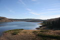
View from the dam over the Wehebachtalsperre

View over the Wehebachtalsperre


See also
literature
- Peter Franke, Wolfgang Frey: Dams in the Federal Republic of Germany. Published by the National Committee for Large Dams in the Federal Republic of Germany (DNK) and the German Association for Water Management and Cultural Building eV (DVWK). Systemdruck-GmbH, Berlin 1987, ISBN 3-926520-00-0 .
Web links
- Abandonment of the Wehebachtalsperre. Eifel-Rur water association , accessed on December 20, 2014 .
- Wehebachtalsperre OW level. Eifel-Rur water association , accessed on December 20, 2014 .
- Dams directory North Rhine-Westphalia. (PDF; 115 KB) State Office for Nature, Environment and Consumer Protection North Rhine-Westphalia , October 1, 2005, accessed on December 19, 2014 .
- Wehebachtalsperre. In: eifel.de. Retrieved December 20, 2014 .
Individual evidence
- ↑ a b c d e f g h i j k l m n o p q r data sheet of the Wehebachtalsperre. (PDF; 696 KB) Eifel-Rur Water Association , accessed on December 20, 2014 .
- ^ Frank Behrenberg: Dams and reservoirs - Wehebach dam. Retrieved December 20, 2014 .
- ↑ Wehebachtalsperre now supplies natural electricity. In: Aachener Nachrichten . October 6, 2011, accessed December 20, 2014 .