Kalltalsperre
| Kalltalsperre | |||||||||
|---|---|---|---|---|---|---|---|---|---|
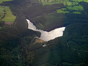
| Aerial view of the Kalltalsperre | |||||||||
|
|||||||||
|
|
|||||||||
| Coordinates | 50 ° 38 '39 " N , 6 ° 18' 33" E | ||||||||
| Data on the structure | |||||||||
| Construction time: | 1934-1935 | ||||||||
| Height above valley floor: | 34 m | ||||||||
| Height above foundation level : | 40 m | ||||||||
| Height above the river bed : | 38.5 m | ||||||||
| Building volume: | 230 000 m³ | ||||||||
| Crown length: | 180 or 182 m | ||||||||
| Crown width: | 5 m | ||||||||
| Operator: | Water extraction and treatment company Nordeifel | ||||||||
| Data on the reservoir | |||||||||
| Altitude (at congestion destination ) | 420.77 m | ||||||||
| Water surface | 18 ha | ||||||||
| Storage space | 2.1 million m³ | ||||||||
| Catchment area | 29 km² | ||||||||
The Kalltalsperre is a drinking water dam near Simmerath - Rollesbroich near Monschau in the Aachen city region .
description
With the construction of the Kalltalsperre, which dams the river Kall , was started on March 21, 1934 as a government program to create jobs. The construction of the Heimbach dam and the Rurtalsperre Schwammenauel also began in 1934 . The dam was dammed for the first time on January 8, 1936 and inaugurated on August 23, 1936. The 6.2 km long Kall tunnel leads from the Kalltalsperre to the Dreilägerbachtalsperre . As early as 1926 there had been a connecting tunnel for the transfer of raw water from the brooks of the Kall valley to the Dreilägerbachtalsperre.
With the expansion of the Rurtalsperre and the Obersee between 1955 and 1959, a raw water extraction line was also built from the Obersee of the Rurtalsperre to the Hasenbachtal and from there through the 3.7 km long Heinrich-Geis tunnel to the Kalltalsperre.
The earth dam has a concrete core and is 34 meters high. The dam volume is also given as 244,000 m³; possibly this is the volume with the 13,000 m³ thick concrete core and 230,000 the volume without the core. A control corridor is integrated at the foot of the core panel, in which a large number of measuring devices are installed to monitor the dam. The inspection passage is crossed by bottom drain tunnels in the deepest part of the valley. There are 2 steel pipelines running here through which the dam can be emptied. At the end of these lines there is a hydropower plant in which the water of the compulsory charge to the Kallunterlauf is converted into electrical energy.
The raw water is extracted via a extraction tower located in the reservoir at the head of the Kall gallery. The water intended for drinking water treatment is also fed through the turbine of a hydropower plant with an electrical output of 227 kW. An average of 450,000 kWh of electrical energy is generated each year. (As of 2005) The so-called culvert pipeline , which connects to the Heinrich Geis tunnel , continues to connect to the extraction tower . This pipeline enables raw water to pass through from the Obersee of the Rurtalsperre to the drinking water treatment plant at the Dreilägerbachtalsperre near Roetgen, without it being mixed with the raw water of the Kalltalsperre.
The operator is the water extraction and treatment company Nordeifel , a 50 percent subsidiary of enwor-energie & wasser vor ort GmbH and a 50 percent subsidiary of Stadtwerke Aachen .
Freetime activities
In terms of leisure and recreational opportunities, hiking and cycling are possible. Bathing or water sports are not permitted because it is a drinking water reservoir. There is a circular path around the dam, which can be easily reached on foot from the Kallbrück hiking car park. - The technical systems can be viewed on request.


