
Hill (creek)
| Hill | ||
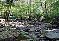
 The Hill near the Botrange |
||
| Data | ||
| location | Liege Province , Belgium | |
| River system | Rhine | |
| Drain over | Weser → Ourthe → Maas → Hollands Diep → North Sea | |
| River basin district | Meuse | |
| source | Near the botrange | |
| Source height | 660 m | |
| muzzle | In Eupen in the Vesdre Coordinates: 50 ° 37 ′ 18 " N , 6 ° 2 ′ 21" E 50 ° 37 ′ 18 " N , 6 ° 2 ′ 21" E |
|
| Mouth height | 250 m | |
| Height difference | 410 m | |
| Bottom slope | 16 ‰ | |
| length | 25 km | |
The Hill ( French : Helle ) is a stream in the High Fens in eastern Belgium .
course
The Hill rises near the highest point in Belgium, the Botrange . It flows into Eupen , 25 km further north, into the Weser (Vesdre).
The most important inflows are the Spoorbach and the Thrush . The confluence of the Hill and Spoorbach rivers is 10 km downstream near the village of "Herzogenhügel". This place is of geological interest, the only rock of volcanic origin in eastern Belgium can be found in a quarry. Shortly before Eupen, at the place called “Black Bridge”, the thrush flows into the Hill.
The Hill as a state border
During Roman times it was the border between the administrative areas of Tongeren ("Civitas Tungrorum") and Cologne ("Civitas Agrippinensium").
From the High Middle Ages until 1795 it was the border of the lordships that divided the area of the High Fens. So here was the border between the Duchy of Limburg and the Duchy of Luxembourg and further north, in the area of the Duke Hill, between Limburg and the Duchy of Jülich .
From 1815 to 1919 it separated Prussia from the United Kingdom of the Netherlands and its successor state Belgium.
In 1952, a 1.5 km long connecting tunnel was dug between the Hill and the Eupener Wesertalsperre in order to better regulate the high water consumption of the textile industry. About half of its way the Hill flows through the Hohes Venn-Eifel Nature Park .
Web links

Surrounding the hill
Confluence of the thrush in the hill

The Hill flows into the Weser

Entrance of the tunnel that carries the water from the Hill to the Weser Reservoir


.jpg)