Elliðaár
| Elliðaár | ||
|
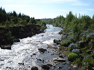
Elliðaárdalur with the river Elliðaár |
||
| Data | ||
| location | Höfuðborgarsvæðið , Iceland | |
| River system | Elliðaár | |
| origin |
Elliðavatn 64 ° 5 ′ 37 ″ N , 21 ° 47 ′ 31 ″ W. |
|
| muzzle | in Reykjavík in the bay Elliðaárvogur (side bay of Faxaflói ) Coordinates: 64 ° 8 ′ 2 ″ N , 21 ° 50 ′ 9 ″ W 64 ° 8 ′ 2 ″ N , 21 ° 50 ′ 9 ″ W |
|
| Mouth height | 0 m | |
| Height difference | 73 m
|
|
| Catchment area | 270 km² | |
| Drain |
NNQ HHQ (1968) |
2 m³ / s 110 m³ / s |
| Big cities | Reykjavík | |
| Communities | Kópavogsbær , Reykjavíkurborg | |
The Elliðaár [ ˈɛtlɪðaˌauː ] is a river in southwest Iceland .
Surname
The name, the base word of which is a plural of "á" = river, comes from the ship of one of the first settlers in Iceland in the 9th century, which was called Elliði , according to the land book .
geography
The exact source of the river is not entirely clear.
Its source rivers are actually in the volcanic mountain range of the Bláfjöll . On the way to Elliðavogur Bay in Reykjavík, you cross the Heiðmörk nature reserve . But the Elliðaár river flows out of the Elliðavatn lake and past the Árbæjarsafn open-air museum on the western edge of Reykjavík . On its way to the sea, the river forms some small waterfalls within the capital area.
history
Ownership and, above all, fishing rights on the river have always been coveted because of its salmon .
There is evidence that the river was owned by the medieval Augustinian monastery on Viðey Island from an early age . After the Reformation in the 16th century, it came into the possession of the Danish king.
In 1853 the Danish royal family finally sold the rights to the river to the Reykjavík merchant Ditlev Thomsen. After his son inherited these, a legal dispute arose over the rights that lasted no less than 14 years. Between 1900 and 1906 the river was briefly owned by an Englishman, a certain Mr. Payne, after which it was owned by the City of Reykjavík until 1921.
Elliðaárvirkjun power station
The first power station to supply Reykjavík was built on this river in 1921 . There is a museum about it in the buildings. Wooden water pipes in front of it also bear witness to this. Since then, the river has belonged to the electricity companies, which also have the fishing rights.
Elliðaárdalur valley
Elliðaárdalur is one of Reykjavík's recreational areas with many hiking and biking trails. There is also a swimming pool, a small ski lift, and riding stables and trails.
Efforts have been made to reforest here since the beginning of the 20th century . You can find forests with birch , pine , fir and spruce trees .
The valley is also suitable for bird watching with a total of 60 species, including swans , 8 different species of ducks and many songbirds such as the thrush .
Volcanism
Basalt lies at the bottom of the valley . It is v. a. around lavas from a volcanic eruption of the Leitin crater in Bláfjöll , part of the Brennisteinsfjöll volcanic system 4,500 years ago.
See also
Web links
Individual evidence
- ↑ a b c d e f g h i Íslandshandbókin. Náttúra, saga og sérkenni. 2. bindi. Edited by T. Einarsson, H. Magnússon. Örn og Örlygur, Reykjavík 1989, pp. 20f.
- ^ HU Schmid: Dictionary Icelandic - German. Buske, Hamburg, 2001, 12
- ↑ Orkuveita Reykjavíkur: Elliðaárvirkjun ; Retrieved September 7, 2012
- ↑ cf. z. B. Nat.is: Ellidaardalur ; Retrieved September 7, 2012
- ^ GVP: Brennisteinsfjöll, Eruptive History ; accessed: September 7, 2012
