Elliðavatn
| Elliðavatn | ||
|---|---|---|

|
||
| Geographical location | Iceland | |
| Tributaries | Bugðá and Suðurá | |
| Drain | Elliðaár | |
| Data | ||
| Coordinates | 64 ° 5 '11 " N , 21 ° 47' 8" W | |
|
|
||
| surface | 1.8 km² | |
| Maximum depth | 7 m | |
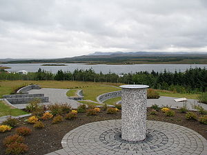
The Elliðavatn [ ˈɛtlɪðaˌvahtn̥ ] is a lake in Iceland . It is located in the suburbs of the capital Reykjavík in the municipal area of Reykjavíkurborg and Kópavogur .
geography
The area of Elliðavatn is 1.8 km². Nearby is the Heiðmörk recreational area with hiking and biking trails, forests and lava formations.
If you approach the capital via the Hellisheiði , the lake is on the left hand side behind the Rauðhólar , a series of pseudocraters who were used as a quarry for road construction purposes and the like and are therefore only partially preserved.
The lake is fed by two small rivers from the Bláfjöll : Bugðá and Suðurá . The Elliðaár River flows from the lake over five kilometers to the sea. The river sometimes brings copious amounts of sulfur from the mountains, which are active volcanoes . But it is also one of the ten best salmon rivers in the country.
history
The first power station in Reykjavík was fed from it and the lake was additionally dammed in 1928 for the purpose of generating energy. There is still a small power station there and a small museum on the same subject.
Recreation
The valley of the river with small waterfalls and forests forms a recreational area of the city of Reykjavík and is well developed with hiking, riding and cycling trails.
