
Gondelsheim (Weinsheim)
|
Gondola home
Local community Weinsheim
Coordinates: 50 ° 14 ′ 2 ″ N , 6 ° 30 ′ 4 ″ E
|
||
|---|---|---|
| Height : | 545 m above sea level NHN | |
| Residents : | 223 (Jun 1, 2014) | |
| Incorporation : | 1st January 1971 | |
| Postal code : | 54595 | |
| Area code : | 06558 | |
Location of Gondelsheim in Rhineland-Palatinate |
||
_01.jpg) |
||

Gondelsheim is a district of the local community Weinsheim in the Eifelkreis Bitburg-Prüm in Rhineland-Palatinate .
location
Gondelsheim is located in the valley of the Vlierbach, which flows past the southern edge of the village. The Seimersberg rises in the north. The district roads K 172 and K 178 run through the village . Neighboring towns are Schwirzheim in the east, Baselt in the south and Weinsheim in the west.
history
In 1988 Roman litter fragments from the 2nd and 4th centuries AD were found south of Gondelsheim. Thus, people were already settling in the Gondelsheim area at this time.
On January 1, 1971, the previously independent community of Gondelsheim was incorporated into the local community of Weinsheim.
Attractions
- Roman Catholic parish and pilgrimage church of St. Fides, built in the 15th century

St. Fides left choir

right choir room

Mary Altar

left nave

“A jewel of the late Gothic two-nave hall style”
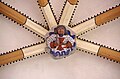
Keystone

Console figure
_13.jpg)
_45.jpg)
_46.jpg)
_42.jpg)
_63.jpg)
_57.jpg)
_38.jpg)
Population development
| year | Residents |
|---|---|
| 1933 | 181 |
| 1939 | 186 |
| 2014 | 223 |
Web links
Individual evidence
- ^ Local community Weinsheim , on www.pruem.de
- ^ Entry on Roman litter shards (Gondelsheim) in the database of cultural assets in the Trier region ; accessed on March 11, 2016.
- ↑ Official municipality directory (= State Statistical Office of Rhineland-Palatinate [Hrsg.]: Statistical volumes . Volume 407 ). Bad Ems February 2016, p. 181 (PDF; 2.8 MB).
- ^ Michael Rademacher: German administrative history from the unification of the empire in 1871 to the reunification in 1990. Population figures in the district of Prüm. (Online material for the dissertation, Osnabrück 2006).