
Outcrop
In mining, the part of a deposit that ends at the mountain surface is referred to as an outcrop , smear or outflow . The term mountain surface does not necessarily refer to the surface of the terrain, but to the surface of the rock ( mountain in the mining sense ), which is not infrequently covered by soil (mining, outdated: Dammerde ). In geology , the term is broader and does not just refer to deposits.
Occurrence and conclusions about the deposit
In the case of a horizontal ( bottom ) or weakly dipping deposit, as it is e.g. B. is often the case in Germany with coal seams , outcrops occur mainly on topographical irregularities of the terrain, z. B. at terrain steps . In the event of a steep or seigeren storage of a seam or Ganges outcrops are also possible in flat terrain. With steep dips, the outcrops of seams are also referred to as layer heads.
Minerals formed under reducing chemical conditions are converted into other minerals through oxidation in the area of the outcrop over the years and millennia, and relatively easily soluble minerals can be carried away by surface water. This oxidation zone is called the Iron Hat in ore deposits .
The size of the outcrop often does not allow precise conclusions to be drawn about the deposit. It can even happen that a rich outcrop leads to the discovery of a poor deposit and an inconspicuous bite leads to an extensive and rich deposit.
Finding outcrops
In early mining, the outcrops were important clues as to where flint or ore could be found. The most common outcrops are on mountain slopes. They could be found by the prospector working his way up from a pile of severed mineral lumps. The steeper the slope, the further away the mineral lumps were from the outcrop . If outcrops were covered with soil, the search for them was much more difficult. These outcrops could only be found through intensive prospecting . The places that the prospector wanted to work, he first examined very carefully for uneven ground or searched them for rocks. Most of the ore levels were usually larger than the other rubble lying around or the so-called dam soil, which made it relatively easy to define a prospect.
Today, deposits and veins can be recorded more completely by exploring them geophysically (see also exploration ).
Picture gallery
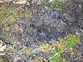
- Outcrops in the mining sense

Geological natural monument: visible outcrop of the soot-coal seam ( Westfalium of the Vorerzgebirgs-Basin )
Detail of the soot coal seam on the left bank of the Zwickauer Mulde
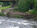
Soot coal seam, right bank of the Zwickauer Mulde
Open outcrop of the Rote Kamm , a hydrothermal quartz hematite dike near Bad Schlema, Ore Mountains, Saxony

Exposed outcrop of a quartz vein near Cape Jervis, South Australia

Exposed outcrop of a quartz vein near the Westmoreland uranium deposit , Queensland


Concept of outcrop in geology
The terms outcrop and streak in geology are derived, like many other geological terms, from the miner's language, but have a somewhat less special meaning. They refer not only to deposits of mineral resources, but simply designate the line or area of intersection of any geological structure with the earth's surface. Here, too, it does not matter whether this structure is actually open-minded or not, i. In other words, “earth's surface” is not synonymous with “ground surface”, since the outcrop can be completely or partially covered by soil .
The size of an outcrop in the geological sense depends on the scale or structure considered. The latter can be areas such as strata or fault areas or the thrust front of an entire range of folds, such as. B. the Alps , or rock bodies, such as a single layer, a mighty sequence of layers, a ceiling unit , a small corridor or a huge batholith or even a much larger, very complex rock unit, such as. B. the Bohemian mass . The graphical representation of the outcrop of fault surfaces and rock bodies in a particular region is the main subject of a geological map .
literature
- Johann Grimm: The deposits of usable minerals. JG Calve'sche kk Univ.-Buchhandlung Ottomar Beyer, Prague 1869 - scan
Individual evidence
- ^ Charles Pierre Mathieu Combes: Handbook of mining art, or the theory of exploration and extraction of usable minerals. German edited by Carl Hartmann. Second edition. First volume. Verlag Bernhard Friedrich Voigt, Weimar 1852, p. 2, online at HathiTrust Digital Library
- ^ Moritz Ferdinand Gätzschmann: Collection of mining expressions. Verlag von Craz & Gerlach, Freiberg 1859, p. 10f., Online at Bayerische Staatsbibliothek digital / Munich digitization center, digital library
- ^ Franz XM Zippe: Instructions for rock and soil science, or the most important things from mineralogy and geognosy for educated readers of all levels, especially for farmers, foresters and construction technicians. JG Calve'sche Buchhandlung, Prague 1846, p. 380, online at bavarica.digitale-sammlungen.de
- ^ Walter Bischoff , Heinz Bramann, Westfälische Berggewerkschaftskasse Bochum: The small mining dictionary. 7th edition, Verlag Glückauf GmbH, Essen, 1988, ISBN 3-7739-0501-7
- ↑ Explanatory dictionary of technical terms and foreign words used in mining, metallurgy and salt works. Falkenberg'schen Buchhandlung publishing house, Burgsteinfurt 1869
- ^ Rammelsberg World Heritage Site: The Bite of the Old Camp (last accessed on March 4, 2013)
- ^ Heinrich Veith: German mountain dictionary with evidence. Published by Wilhelm Gottlieb Korn, Breslau 1871
- ↑ Friedrich August Walchner: Handbuch der Geognosie for use in his lectures and for self-study. Second improved and increased edition, printed and published by Christian Theodor Groos, Karlsruhe 1847
- ↑ Carl Hartmann (ed.): The loyal leader in mining and drilling. Third completely revised and enlarged edition, printed and lithographed by BF Voigt, Weimar 1856
- ↑ a b Christiane Martin, Manfred Eiblmaier (ed.): Lexicon of Geosciences: in six volumes , Heidelberg [u. a.]: Spectrum, Akad. Verl., 2000-2002
- ^ Hans Murawski, Wilhelm Meyer: Geological dictionary. 12th edition. Spektrum Akademischer Verlag, 2010, p. 37, ISBN 978-3-8274-1810-4