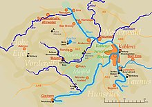
Middle Rhine basin
The Middle Rhine Basin is the central partial landscape on the Middle Rhine and, together with the Limburg Basin, forms one of the larger intramontaneous subsidence areas within the Rhenish Slate Mountains . The valley is divided into the valley widening of the Neuwied Basin , the right bank Neuwieder pool deck and left bank in the Lower Moselle valley in the south and the Maifeld-Pellenzer hills in the north.
The basin is bounded on the right bank of the Rhine in the northeast and east by the slopes of the Westerwald and on the left bank of the Rhine from north to southwest by the Eifel and in the southeast by the valley of the Moselle above the Moselle core . Its mild winter and rain-free climate enables intensive agricultural use, which also causes the poor forest of this landscape.
Natural structure
The handbook of the natural spatial structure of Germany assigns the Middle Rhine Basin to the main unit group 29, the Middle Rhine region, lists it as main unit 291 itself and subdivides it into the following sub-units:
-
(to 29 - Middle Rhine area )
- 291 Middle Rhine Basin
- 291.0 Neuwied Rhine valley widening (Rhine valley)
- 291.1 Neuwied basin edge (right bank of the Rhine)
- 291.10 Hüllenberger edge terrace
- 291.11 Wollendorf-Gladbach basin slope
- 291.12 Ehrenbreitsteiner edge terrace
- 291.2 Maifeld-Pellenz hill country (left bank of the Rhine)
- 291.20 Andernach-Koblenz terrace hill in the broader sense (left bank of the Rhine)
- 291.200 Andernach-Koblenz terrace hill in the narrower sense (left of the Rhine and Moselle)
- 291.201 Koblenz Moselle Valley
- 291.202 Karthauser (right of the Moselle and left of the Rhine)
- 291.21 Karmelenberghöhe (clearly to the left of the Rhine)
- 291.22 Pellenz valley and hill country (clearly to the left of the Rhine)
- 291.220 Pellenz Volcanoes
- 291.221 pellet sink
- 291.222 pellet height
- 291.23 Niedermaifeld (left bank of the Rhine)
- 291.230 Niedermaifelder valley
- 291.231 Niedermaifelder terrace
- 291.232 Niedermaifelder Höhe
- 291.24 Obermaifeld (west)
- 291.25 Mayener Kessel (west)
- 291.20 Andernach-Koblenz terrace hill in the broader sense (left bank of the Rhine)
- 291.3 Lower Moselle Valley (left bank of the Rhine)
- 291.30 Dieblicherberg terrace (on the right of the Moselle)
- 291.31 Lower Moselle valley basin ( Moselle from Moselkern to Lay )
- 291 Middle Rhine Basin
New basin
→ Main article: New basins
This valley widening, also known as the Koblenz-Neuwied Basin , and located between the cities of Koblenz and Neuwied , separates the narrow valley of the upper and lower Middle Rhine over a length of approx. 22 kilometers . Due to its fertile soil, the Neuwied Basin has been inhabited since the earliest times. The landscape today is characterized by intensive fruit cultivation as well as industrial settlements. In the compression chamber of the Neuwied Basin approximately 300,000 inhabitants.
Cities
Maifeld
→ Main article: Maifeld
This south-western part of the Middle Rhine basin is particularly noticeable due to its slight hills. It is bounded by the river valleys of the Moselle (to the south-east) and the Elz (to the south-west) cut deep into the hill country ; Northwest border is z. T. the nice one . This area is mainly used for agriculture. The soils are considered particularly fertile. Cities in the Maifeld are Polch (seat of the Maifeld Association in the Mayen-Koblenz district , but strictly speaking located in Pellenz ) and Münstermaifeld .
The Pellenz
→ Main article: Pellenz
This hill country forms the north-western part of the valley between Mayen and Andernach . It is characterized by agriculture and opencast mining ( pumice and lava sand ) and the associated building materials industry. The small river Nette flows through the hilly landscape, gently sloping from west to east towards the Rhine , with its memorable volcanic peaks (which are mostly excavated) , limiting the landscape mainly south to the Maifeld .
The predominantly industrial towns of Plaidt , Ochtendung , Kruft , Nickenich and Kretz ( Pellenz volcanoes , east) as well as Niedermendig (today Mendig ), Kottenheim , Thür ( Pellenzsenke , west) and the Polch ( Pellenzhöhe , south), which protrude into the Maifeld belong to Pellenz . The area is conveniently located on the A 61 motorway and the Eifel-Pellenz Bahn . During excavations in Pellenz, settlement remains from over 300,000 years ago, Celtic as well as Roman settlement remains and burial grounds were found. The Wernerseck Castle is interesting for tourists .
Pellenz is also the name of a municipality in Rhineland-Palatinate , which includes the north of the Pellenz landscape and is based in Plaidt .
Individual evidence
- ↑ Heinz Fischer, Richard Graafen: Geographical land survey: The natural space units on sheet 136/137 Cochem. Federal Institute for Regional Studies, Bad Godesberg 1974. → Online map (PDF; 5.6 MB)
- ↑ Heinrich Müller-Miny, Martin Bürgener: Geographical land survey: The natural spatial units on sheet 138 Koblenz. Federal Institute for Regional Studies, Bad Godesberg 1971. → Online map (PDF; 5.7 MB)
- ↑ Map service of the landscape information system of the Rhineland-Palatinate nature conservation administration (LANIS map) ( notes )
- ↑ Landscape profile of the large landscape 29 of the landscape information system of the nature conservation administration Rhineland-Palatinate ( notes )
- ↑ Page 138 Koblenz only mentions 291.201 and 291.202 in the text part and inscribes the supervisory unit minus 291.201 and 291.202 with the number 291.20
- ↑ Sheet 138 Koblenz uses No. 291.3 on the map for the lower Moselle valley minus sub-unit 291.30.
General sources
literature
- Frauke Gränitz et al. (Ed.), The Middle Rhine Basin. A geographical inventory in the Andernach, Bendorf, Koblenz, Mayen, Mendig, Münstermaifeld and Neuwied area (volume 65 of the series " Landscapes in Germany "), Cologne / Weimar / Vienna: Böhlau 2003, ISBN 3412101028 (basic geographical inventory)


