Elzbach
| Elzbach | ||
|
Location of the Elzbach in the region |
||
| Data | ||
| Water code | EN : 2696 | |
| location | Eifel , Rhineland-Palatinate , Germany | |
| River system | Rhine | |
| Drain over | Moselle → Rhine → North Sea | |
| source | On the Hochkelberg near Bereborn in the High Eifel 50 ° 17 '8 " N , 6 ° 57' 13" E |
|
| Source height | approx. 565 m above sea level NHN | |
| muzzle | At Moselkern in the Moselle coordinates: 50 ° 11 ′ 23 ″ N , 7 ° 22 ′ 10 ″ E 50 ° 11 ′ 23 ″ N , 7 ° 22 ′ 10 ″ E |
|
| Mouth height | approx. 74 m above sea level NHN | |
| Height difference | approx. 491 m | |
| Bottom slope | approx. 8.3 ‰ | |
| length | 58.9 km | |
| Catchment area | 220.686 km² | |
|
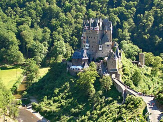
The Elzbach and Eltz Castle |
||
The Elzbach (also known as the Elz for short ) is a 58.9 km long orographically left tributary of the Moselle in Rhineland-Palatinate , Germany .
geography
It rises in Rhineland-Palatinate in the Hohe Eifel on the Hochkelberg ( 674.9 m above sea level ) near Bereborn and flows primarily in an easterly direction, first to Monreal , and then, turning south-southeast, flows into the Moselle at Moselkern . At Kaifenheim , the Elz is spanned by a 97 m high A48 motorway bridge , the Elztalbrücke . In the deeply incised lower reaches of the Pyrmont Castle with the Elz waterfall and Eltz Castle on a rock above a loop .
In its lower reaches, the Elz separates the gently hilly Maifeld landscape from the Moselle Eifel . This is why the Eifel side of the Elz is still sometimes called “Üver-Elz” by the Maifeldern.
On the way from the source to the mouth, the Elz passes the following places: Bereborn , Retterath , Lirstal , Oberelz , Bermel , Niederelz , Monreal , Düngenheim , Kehrig , Kaifenheim , Gering , Kollig , Roes , Pillig , Möntenich , Keldung , Wierschem and Moselkern .
history
The name Elz is probably of Celtic origin. The alder, called Els or Else in Old High German , is common in the Elz valley. The headwaters of the small river, Bereborn in the Eifel, is also called In den Erlen . The Elz was already described by the Roman poet Ausonius in 372 AD. The Latin name was Alisontia . There it says: No less than it, the Elz grazes past fertile banks through fat areas of blessing.
Traffic routes / hiking trails
There is only a road along the upper course to Monreal, the lower course is idyllically located in the deep valley and can be explored on foot or partly by bike. A hiking route from Monreal to the Moselle is well signposted and forms part of the Way of St. James . The entire route is about 33 km long. However, it is possible to start the hike to the Moselle at the following points:
- At the Lohbrücke between Düngenheim and Kehrig (26 km), 50 ° 15 ′ 59.7 ″ N , 7 ° 11 ′ 55.3 ″ E
- At the Kehriger Mühle between Kaifenheim and Kehrig (22 km), 50 ° 15 ′ 43.9 ″ N , 7 ° 13 ′ 39.8 ″ E
- At the bridge mill between Roes and Kollig (17 km), 50 ° 15 ′ 7 ″ N , 7 ° 16 ′ 12 ″ E
- At the Pyrmonter Mühle between Roes and Pillig (13 km), 50 ° 14 ′ 11.1 ″ N , 7 ° 17 ′ 28.9 ″ E
- In Möntenich (10 km), 50 ° 13 ′ 29.1 ″ N , 7 ° 18 ′ 17.9 ″ E
See also
Individual evidence
- ↑ a b Topographic map 1: 25,000
- ↑ a b GeoExplorer of the Rhineland-Palatinate water management authority
- ↑ Ausonius: Mosella . 371.
literature
- Max Him : Alisontia . In: Paulys Realencyclopadie der classischen Antiquity Science (RE). Volume I, 2, Stuttgart 1894, column 1497.


