Rockeskyller head
| Rockeskyller head | ||
|---|---|---|
|
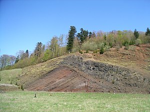
Section through the crater rim of the cinder cone |
||
| height | 554.6 m above sea level NHN | |
| location | at Rockeskyll ; Vulkaneifel district , Rhineland-Palatinate ( Germany ) | |
| Mountains | Eifel | |
| Coordinates | 50 ° 15 '10 " N , 6 ° 40' 46" E | |
|
|
||
| Type | extinguished cinder cone | |
| rock | Basalt and molten red sandstone | |
| Age of the rock | Quaternary , (approx. 360,000 years) | |
|
Rockeskyller Kopf (center left) with Kasselburg (center right) |
||
The Rockeskyller Kopf near Rockeskyll in the Rhineland-Palatinate district of Vulkaneifel is 554.6 m above sea level. NHN high mountain in the Eifel . It is an extinct volcano complex from the Quaternary period , around 360,000 years old and designated as a natural monument (ND-7233-420).
geography
location
The Rockeskyller Kopf is located in the Vulkaneifel Nature Park . Its summit rises about 1 km west of Rockeskyll , 1 km east of Bewingen and 1.6 km southeast of Dohm-Lammersdorf . The Kaulbach flows east past the mountain as the right source brook of the Hangelsbach brook to the south-east ; the latter flows southeast of the mountain near the Pelm residential area Schloßbrunnen Gerolstein into the Kyll, which runs southwest to south of it .
Natural allocation
The Rockeskyller Kopf belongs in the natural spatial main unit group Eastern Eifel (No. 27), in the main unit Kalkeifel (276) and in the subunit Northern Vulkaneifel (276.8) to the natural areas Kyll-Vulkaneifel (276.80) in the west and Dockweiler Vulkaneifel (276.81) in the east .
Volcanic environment
The Rockeskyller Kopf is part of a volcanic complex that consists of several nested cinder blocks. The neighboring peaks Mäuseberg and Giesenheld are also part of it. Experts assume there will be five to seven eruption sites that have successively built up and overlapped in the course of volcanic activity.
The cinder cone is the typical positive landscape and volcanic shape of the Eifel - in contrast to the maars , which, as explosive funnels, represent a negative landscape shape.
Construction history
As with maars , the construction of the Rockeskyller head began with steam explosions that piled up coarse-grained lapilli . This was followed by strombolian eruptions , as the intermittent ejection of glowing slag is called. The hot slag melted into welding slag on impact , which can easily be mistaken for lava flows . In the final phase, lava flows were ejected, the remains of which can still be seen as a lava cover or chimney filling .
The image of the trimmed crater rim shows this sequence. The reddish layers falling to the left are the lapilli deposits. On the right flank there is first a thin layer of tuff deposits and only then the thicker black layer of welding slag.
Protected areas
On the Rockeskyller head lying parts of the protected landscape Gerolstein and the surrounding area ( CDDA -No 321065;. Reported in 1983; 124.1171 square kilometers in size) and those of the bird sanctuary Eifel (VSG No. 5706-401;. 11.25 square kilometers).
See also
literature
- Volcanological map of the West and High Eifel 1: 50,000 by G. Büchel; Institute for Geosciences Uni Mainz, 1994
- Vulkan Rockeskyller Kopf - Flyer of the Georoute Gerolsteiner Land (P. Bitschene), 2007
- Cliff SJ Shaw, Alan B. Woodland, Jens Hopp and Nesha D. Trenholm: Structure and evolution of the Rockeskyllerkopf Volcanic Complex, West Eifel Volcanic Field, Germany in Bulletin of Volcanology ( doi : 10.1007 / s00445-010-0380-9 )
Web links
- Rockeskyller Kopf volcanic complex at the State Office for Geology and Mining Rhineland-Palatinate, on lgb-rlp.de
- The Rockeskyller head as a research object , on scinexx.de
- Rockeskyller Kopf (Kyller Kopf) (mineral database), on mindat.org
Individual evidence
- ↑ a b Map service of the landscape information system of the Rhineland-Palatinate Nature Conservation Administration (LANIS map) ( notes )
- ↑ Hans-Ulrich Schmincke: Volcanoes of the Eifel . Spektrum Akademischer Verlag, Heidelberg 2009, ISBN 978-3-8274-2366-5 , page 49
- ↑ Map services of the Federal Agency for Nature Conservation ( information )


