
High simmer
| High simmer | ||
|---|---|---|
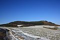
 The Hochsimmer with Sankt Johann (left) and Ettringen (right) |
||
| height | 587.9 m above sea level NHN | |
| location | near Ettringen ; Mayen-Koblenz district , Rhineland-Palatinate ( Germany ) | |
| Mountains | Eifel ( Eastern High Eifel ) | |
| Coordinates | 50 ° 21 '38 " N , 7 ° 11' 55" E | |
|
||
| Type | Cinder cone | |
| rock | basalt | |
| particularities | Hochsimmerturm ( AT ) | |

.JPG)

The Hochsimmer is 587.9 m above sea level. NHN high volcanic cone of the Eifel . It is located near Ettringen in the Rhineland-Palatinate district of Mayen-Koblenz ( Germany ). The Hochsimmerturm observation tower stands on top of it .
geography
location
The Hochsimmer rises within the Hohen Eifel ( Eastern Eifel ) around 1.7 km west-north-west of the core town of Ettringen , whose municipal boundary to St. Johann , located south of the mountain, runs exactly over the ridge in the summit area. A section of the middle reaches of the Rhine tributary, Nette, flows past its west foot , roughly in a north-south direction . State road 83 , which connects Weibern in the northwest with Mayen in the southeast, runs through the valley . At the east foot of the mountain lies Ettringen on the L 82 leading to Bell , at its south foot is St. Johann.
The 5th stage of the Eifelverein's main hiking trail 1 leads from Maria Laach over the Hochsimmer and on to the Hammesmühle in the Nettetal.
Natural allocation
The Hochsimmer lies on the border of the natural spatial main unit groups Middle Rhine area (29) with the main unit Lower Middle Rhine Area (292), the subunit Laacher Vulkane (292.0) and the natural area Ettringer volcanic peaks (292.01) in the east and Eastern Eifel (No. 27) with the main unit Eastern Hocheifel (271), the subunit Hohe-Acht / Nitz-Nette-Bergland (271.2) and the natural area Nitz-Nette-Wald (271.21) in the west. To the north the landscape leads into the sub-unit Kempenich tuff plateau (271.1) and to the south into the natural area Mayener Kessel (291.25), which belongs to the sub-unit Maifeld-Pellenzer Hügelland (291.2) in the main unit Middle Rhine Basin (291) .
Mountain height and hilltops
The Hochsimmer has two peaks: the west knoll ( ⊙ ) is 587.9 m and the east knoll ( ⊙ ) 583.3 m high. The Kleine Simmer ( 514.7 m ) joins about 600 m southwest of the mountain summit .
Protected areas
On the wooded Hochsimmer are the nature reserve Hochsimmer ( CDDA 2.4914 -No 81,899th; in 1973 reported km² large) and parts of the protected landscape area Rhein-Ahr-Eifel (CDDA No. 323834;. 1980; 925.8651 square kilometers).
Towers
The 18 m high Hochsimmer tower , an observation tower built from 1909 to 1911, stands on the eastern summit of the Hochsimmer in the district of St. Johann . From its viewing platform , you can see the Eastern High Eifel , the Middle Rhine Basin and down to Ettringen; in good visibility it extends to Cologne Cathedral . There is a transmission tower about 30 m northwest of the Hochsimmerturm, and a transmission mast about 25 m south .
gallery
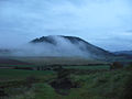
Hochsimmer from the south

East tip from the south
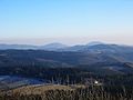
Hochsimmer (right), seen from the Hohe Acht
View from the Hochstein


Individual evidence
- ↑ a b c d e Map service of the landscape information system of the Rhineland-Palatinate Nature Conservation Administration (LANIS map) ( notes )
- ↑ Osteifelweg (1) - 5th stage on the website of the Eifelverein
- ↑ Map services of the Federal Agency for Nature Conservation ( information )
See also
Web links
- Der Hochsimmer… , accessed on November 28, 2013, in the Ettringen am Hochsimmer community , on ettringen-eifel.de

Ausonius stone | Booser Maar | Dr. Heinrich Menke Park | Ettringer and Mayener Bellberg, Kottenheimer Büden | Wetlands in the Nothbach Valley | Goose neck, Schorenberg, Burgberg and Schmitzkopf | Hochbermel | High simmer | Hochstein | Hut pond | Graswerth Island | Karmelenberg | Little Bermel | Korretsberg | Cowboy | Kurbüsch | Mayener pit field | Michelberg | Moselle bank between Niederfell and Dieblich | Namedyer Werth | Nastberg | Nettetal | Heron shot island near Lehmen | Sulzbusch | Clay pit Hüttwohl | Thürer meadows | Juniper heaths Raßberg and Heidbüchel