Karmelenberg
| Karmelenberg | ||
|---|---|---|
|
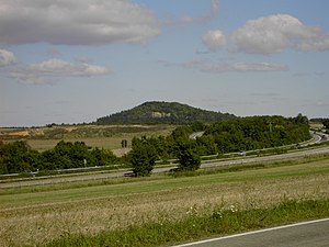
General view, in the foreground the A 48 Koblenz - Trier |
||
| height | 372 m above sea level NHN | |
| location | Mayen-Koblenz district , Rhineland-Palatinate , Germany | |
| Mountains | Maifeld-Pellenz hill country | |
| Coordinates | 50 ° 20 '39 " N , 7 ° 25' 24" E | |
|
|
||
| Type | Cinder cone | |
The Karmelenberg is a wooded cinder cone created by volcanic activity . It marks the southeast end of the Osteifel volcanic field and rises at a height of 372 m above sea level. NHN as a landmark that can be seen from afar about 170 m above the Pellenz .
In the UN Year of the Mountains (2002), the Karmelenberg Mountain of the Month was June in Germany. A memorial stone commemorates the proclamation on June 21, 2002.
As part of the volcano park (station 21), the mountain has been developed for tourism. Various information boards provide information about the volcanic past as well as about the Lady Chapel on the summit.
The current name refers to Mount Carmel, a mountain in the Carmel massif in northwestern Israel .
The entire cinder cone of the Karmelenberg is a nature reserve .
location
The Karmelenberg belongs to the local community of Bassenheim and is in close proximity to the A 48 , exit Ochtendung . Not far away is the Goloring , an important ground monument. The Karmelenberg can be reached from Bassenheim via a 1.5 km long avenue (natural monument ND-7137-386), via Ochtendung or via the L 52 Koblenz - Polch .
geology
The cinder cone of the Karmelenberg is part of a volcanic group with ten eruption centers that was active about 350,000 to 300,000 years ago. In addition to the Karmelenberg main summit, these include the pig's head and the so-called Oberholzgruppe, of which no remains can be seen. The pig's head is almost completely worn away by degradation.
The Karmelenberg group lies partly on the edge of the Neuwied basin . On the north side, the Devonian subsoil, consisting of Hunsrück slate, has sunk by around 100 m. On the south side there are river gravel of the original Moselle . The three lava flows that emerged from the Karmelenberg are covered by pumice and loess .
Dismantling
The large quarry, still visible today, was built in the 20th century. The high vertical walls of the outcrop were created by a special, very risky mining technique. During the so-called hollowing , a low cavity was first carved out at the foot of the wall and supported with wood. After the wooden supports were blasted away, the wall broke down over a large area.
Nature reserve
The "Karmelenberg Nature Reserve" (NSG-7137-031) has a size of 10.74 hectares . It was placed under protection on May 7, 1981 by the Koblenz district government .
The protection purpose is the preservation of the Karmelenberg for scientific and geographical reasons because of its geological composition including its outcrops, as a habitat of rare wild-growing plants in their existence and because of its landscape-defining special scenic beauty and character.
See also
Web links
Individual evidence
- ↑ Ordinance on the "Karmelenberg Nature Reserve" of the Koblenz District Government of May 7, 1981, entered into force on May 19, 1981 (PDF; 86 kB)


