
Goloring

The Goloring bei Wolken near Koblenz is a prehistoric earthwork and a registered cultural monument . The " Eifel - Stonehenge " is one of the most important archaeological sites from the Iron Age in Rhineland-Palatinate .
location
The Goloring is located in the area of the municipality of Kobern-Gondorf in the immediate vicinity of the A 48 . The facility is located on a cordoned-off former Bundeswehr site (a former training facility for service dogs), which can be reached via the L 52 between Koblenz and Polch .
The closest locality is clouds. This local community uses the increasing popularity of the plant for its image. The parish hall has been renamed Goloring-Halle and on the website of the local parish it says: Clouds - Parish on Goloring . In October 2005 the “Förderverein Goloring e. V. “founded in clouds. The surrounding communities of Kobern-Gondorf, Ochtendung , Bassenheim and Wolken have founded this association together with the Mayen-Koblenz district .
The area is at an altitude of about 310 to 320 m above sea level. NN . It slopes gently to the south and southwest.
The Goloring has been part of the Celtic circular hiking trail since autumn 2006 , which leads back to Wolken on approx. 7 km from clouds over the Goloring, the Celtic princely seat on the Karmelenberg and Bassenheim.
description
The system is almost circular. The interior has a diameter of about 175 meters. With wall and moat, the diameter is about 190 meters. In the west, north and south the wall and moat are interrupted by an entrance. The width of the western entrance is about 40 meters, the other two entrances are each about 2 meters wide. In the middle of the interior, about 30 meters from the outer wall, there is an almost circular plateau. In the middle of it, excavations in 1940 discovered a darker discoloration in the ground at a depth of about half a meter. From the excavation findings it can be concluded that there must have been a 50 centimeter thick post 8 to 12 meters high in the middle of the goloring.
The outer wall was raised from the excavation of the trench. The moat is inside the wall. The sequence of layers of the inner plateau suggests that it was artificially piled up. There is naturally grown soil between the ditch and the plateau.
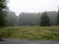
The ring system has now been completely cleared of trees. Many traces of military use by the Bundeswehr have been removed. As a result, the topographical location of the facility is now clearly visible and is becoming more and more effective.
Investigations
The first excavations on the site were carried out in 1940 by Josef Röder . Several excavation cuts were made and essentially the findings described above were made. Since the area had served as the location of a Bundeswehr dog squadron since the 1950s , it was inaccessible for a long time, but it was spared major interventions. A few smaller buildings were only built outside. T. are still available. Since the site was cleared by the German Armed Forces at the end of 2002, the State Office for Archaeological Monument Preservation has been conducting investigations.
Purpose of the facility
The function of the system is unknown. Roeder the facility associated with the type of the mostly from England known Henge to -Monuments that there, however, in the late Neolithic date.
It is very likely that the goloring is not a fortification or a refuge. The terrain is unsuitable and the size of the rampart and moat is insufficient. The fact that the moat is behind the wall speaks against this assumption. In addition, there would have been much more suitable places for this purpose in the vicinity.
The appearance of the entire complex suggests that it was - similar to the Henge monuments - a sanctuary or a place of worship. The fact that there are two extensive burial mound fields in the vicinity supports this assumption.
The stake in the middle in connection with the interruptions in the outer wall and prominent landmarks in the area (e.g. Karmelenberg) could lead to the conclusion that it was a sundial on which certain dates could be read over the course of the year (theory by Wolfgang Zäck, since 1985). A reference to the course of the sun seems possible: on May 7th, the sun sets over the Kamelenberg, an important date for the Celts in the course of the year (according to Dr. Wolfgang Zäck). This relation to the situation was made tangible again by a path cut into the forest.
Age
The construction of the complex is set in the period from 1200 to 600 BC, i.e. in the Urnfield period or the early Hallstatt period .
sightseeing
The entire area is not freely accessible due to its previous military use. Guided tours for registered groups take place rarely and at irregular intervals. The Goloring can be visited on the day of the open monument .
owner
The Goloring has been owned by the Mayen-Koblenz district since June 2004. The purchase price was EUR 90,000.00. It is thanks to the former district administrator of the Albert Berg-Winters district that the facility was taken over by the federal government.
Surname
The name, which was probably not documented before the 19th or 20th century, refers to the legend of the Genoveva of Brabant , who was venerated in the Fraukirch , which is not too far away . It is said that the wrongdoer Golo was executed here.
photos

Location of the post on the plateau, marked by a spruce trunk
View from the central post to the northern entrance (in the left third of the picture)
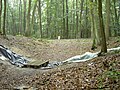
Earth bridge at the southern entrance, in the foreground the current excavation section (9/2004)

The edge of the inner plateau can be seen in this picture (photographed towards the southern entrance). Particularly easy to see on the left of the conifer in the left third of the picture.


literature
- Josef Röder: The Goloring, an Iron Age sanctuary of the Henge character in the Kobern Forest (Koblenz district) , in: Bonner Jahrbücher 1948. P. 81–132. on-line
- Local community Kobern-Gondorf (Ed.): Kobern-Gondorf. 1980
- The Middle Rhine Basin (= values of the German homeland . Volume 65). 1st edition. Böhlau, Cologne / Weimar / Vienna 2003, ISBN 978-3-412-10102-2 , pp. 205-206.
- Wolfgang Zäck: And so his body was divided into four parts. On the trail of the Genovefa legend from the Fraukirch to the Goloring. Mayen 2004. ISBN 3-9806426-6-6 . Pp. 109–138 (speculative)
Further literature on goloring, archaeological
- von Berg, Axel: Studies on urn field culture in the Neuwied Basin (dissertation) 1987. Förderverein Pellenzmuseum e. V .: The Goloring. 1995.
- von Berg, Axel: hunters, farmers, Celtic princes. Koblenz 2001.
- Förderverein Pellenzmuseum e. V .: The Goloring. 1995.
- Joachim, HE: The Iron Age barrow field of Bassenheim. Rhine. Excavation. 32, Cologne 1990.
- Wegner, HH: Guide to Archaeological Monuments in Germany 12, Koblenz and the Mayen-Koblenz District, Stuttgart 1986.
- Wegner, HH: The Celtic sanctuary Goloring. Mayen-Koblenz homeland yearbook 2005.
- Wegner, HH: The Goloring, the Celts and the Maifeld-Pellenzer burial mound groups. Archeology on the Middle Rhine and Moselle 24.
- Wegner, HH: The Goloring. Home Yearbook Mayen-Koblenz 2019.
Further literature on goloring, astronomical-meteorological
- Zäck, Wolfgang: Geographically oriented prehistoric time calculation in the western Middle Rhine basin, Koblenzer geographical colloquium, 1985.
- Zäck, Wolfgang: Sundials in the Eifel, typology and spatiotemporal differentiation (dissertation), Bonn 1987.
- Zäck, Wolfgang: Der Kehrje-Hann, climatology around Mayen, Mayen 1991.
- Zäck, Wolfgang: Throw your shadow, sun, time measurement at Karmelenberg and Goloring, Mayen 1992.
- Zäck, Wolfgang: The Goloring, local history association Ochtendung, Ochtendunger Heimatblätter. 1992.
- Zäck, Wolfgang: Yesterday's Snow, Climate History around the Eifel, Mayen 2000.
- Zäck, Wolfgang: Der Goloring, Heimatjahrbuch, Mayen-Koblenz 2005.
- Zäck, Wolfgang: Pythagoras am Goloring, On the trail of a Celtic geometry, Mayener contributions to local history 13th 2008.
- Zäck, Wolfgang: From the rise of the sun to its fall, Eifeljahrbuch 2011.
- Zäck, Wolfgang: Pythagoras am Goloring, attempt of a mathematical interpretation of the Celtic ramparts, Heimatjahrbuch, Mayen-Koblenz 2011.
- Zäck, Wolfgang: This is how the enclosed district becomes a worldview, The history of earthworks in the Middle Rhine region and dynamic climate change, Mayen 2013.
- Zäck, Wolfgang: The signs are pointing to a storm, climate history around the Eifel, Mayen 2015
Web links
- The Goloring on the sides of the city of Kobern Gondorf
- General Directorate for Cultural Heritage Rhineland-Palatinate
- Article by Wolfgang Zäck
Coordinates: 50 ° 20 ′ 21 ″ N , 7 ° 26 ′ 23 ″ E