Meurin Roman Mine
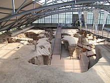
The Meurin Roman mine near Kretz in the Mayen-Koblenz district is the largest Roman underground mining area for tufa north of the Alps . The tuff layer , several meters thick , which was dismantled 2000 years ago , comes from the huge explosion of the Laacher See volcano . The visitors are brought closer to the laborious stone quarrying in Roman times and given an insight into the dark, narrow passages of the underground workers. Outside there is a stonemason's hut and a reconstructed Roman crane system.
The Roman mine is now part of the volcano park and is also part of the national geopark Vulkanland Eifel .
history
Since the Romans mostly only mined the upper layers to a depth of 4 to 6 meters, many of their quarries have been destroyed by subsequent generations who penetrated much deeper into the rock . However, many traces have been preserved on the site of the Trassgrube Meurin near Kretz, which have been made accessible to visitors. In 1960, the mine , rediscovered in the 1950s, was still covered by a 5-meter-high layer of pumice. This layer was excavated in the following years. Many of the Roman tunnels collapsed .
The Office for Prehistory and Early History in Koblenz became aware of the Roman mine in the summer of 1996. On April 1, 1998, archaeologists began excavations. In order to be able to expose the tunnel system, it was inevitable to have the remaining tunnel ceilings supported. After it was recognized that the find was the largest Roman mine north of the Alps, the Mayen-Koblenz district decided together with the volcano park to secure the remains and integrate them into the Geopark . After the district council had approved the necessary funds in 1999, the site was bought.
The biggest problem with securing the mine was water ingress. The solution was to cover the remaining tunnels. The construction work for this began in May 2000. More than 80 bored piles were inserted down to a depth of 20 meters so that the roof, measuring 44.8 × 54.5 meters, had sufficient support. Seven steel lattice girders with a height of 8.5 meters protect the tunnels from further weathering. 150 tons of steel were installed in just 5 months. The total construction costs for the development of the site and the construction of the hall construction amounted to around 4.4 million euros.
For the conception and presentation of this project, the Römerbergwerk was awarded one of the highest European cultural prizes in the category "Archaeological sites" in 2003 by the monument organization Europa Nostra on behalf of the EU.
literature
- Werner P. d´Hein: National Geopark Vulkanland Eifel. A nature and culture guide. Gaasterland-Verlag, Düsseldorf 2006, ISBN 3-935873-15-8
Web links
Individual evidence
- ↑ Römerbergwerk Meurin ( Memento of the original from July 26, 2010 in the Internet Archive ) Info: The archive link was automatically inserted and not yet checked. Please check the original and archive link according to the instructions and then remove this notice. in: General-Anzeiger Bonn
Coordinates: 50 ° 23 ′ 46.5 ″ N , 7 ° 21 ′ 12 ″ E


