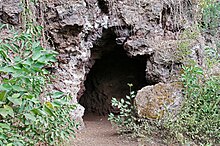
Kottenheimer Büden
The Kottenheimer Büden is the eastern flank of the Bellerberg volcano , a volcanic system between the towns of Ettringen , Kottenheim and Mayen in the Eastern Eifel in the Mayen-Koblenz district .
Emergence
The structure of the Kottenheimer Büden shows the typical structure of a crater flank. Welding slag alternate with slag breccia . Welding slag consists of individual scraps of lava that are fused or welded together because of the high temperature; an indication of the volcano's strong activity. The high proportion of welded slag is also an indication that the center of the eruption was not far. When they hit the rim of the crater, the slag was still malleable, giving it a clear flow structure. The slag breccias, the non-welded slag, are typical representatives of a Strombolian eruption activity. They are made up of angular, bubble fragments and bombs formed in the air . In the cinder wall of the Kottenheimer Büden, the angular pieces are interlocked like a mosaic. This shows that the lava bombs were still frozen in the air and finally broke when they hit the rim of the crater.
use
Artificial caves were carved into the cinder wall during the Second World War , which served as air raid shelters. These so-called "Siewe Stuwe" (seven rooms) were created thanks to the know-how and technical aids from the surrounding quarries, the Ettringer Lay and the Kottenheimer Winfeld . The tunnels were equipped with the essentials such as field beds and bunk beds, shelves and stoves, the entrances camouflaged with branches. The caves offered protection for up to 20 people, mostly women and children from Kottenheim. They lived in the tunnels during the day and used the darkness for errands.
The Kottenheimer Büden is a nature reserve and a landscape monument of the volcano park and is integrated into a circular hiking trail, the dream path volcano path.
literature
- Angelika Hunold: The legacy of the volcano. A journey into the history of the earth and technology between the Eifel and the Rhine. Schnell + Steiner and publishing house of the Roman-Germanic Central Museum , Regensburg / Mainz 2011, ISBN 978-3-7954-2439-8 .
- Eduard Harms and Fritz Mangartz: From Magma to Millstone - A journey through time through the lava flows of the Bellerberg volcano. Publishing house of the Roman-Germanic Central Museum , Mainz 2002, ISBN 3-88467-061-1 .
Web links
- Vulkanpark (official website), on vulkanpark.com
Individual evidence
- ^ Ordinance on the nature reserve "Ettringer Bellberg, Kottenheimer Büden and Mayener Bellberg". (PDF) Landscape information system of the Rhineland-Palatinate Nature Conservation Administration, accessed on January 8, 2015 .
Coordinates: 50 ° 20 ′ 52.8 " N , 7 ° 14 ′ 17.6" E


