
Goose neck
| Goose neck | ||
|---|---|---|
 View from the Hochsimmerturm past the Rodder Höfe with quarry northwards to the goose neck with the goose neck tower |
||
| height | 575.3 m above sea level NHN | |
| location | at Bell ; Mayen-Koblenz district , Rhineland-Palatinate ( Germany ) | |
| Mountains | Eifel | |
| Coordinates | 50 ° 23 '49 " N , 7 ° 12' 17" E | |
|
||
| particularities | Alter Gänsehalsturm ( AT ), Gänsehalsturm (directional radio and observation tower) | |

The goose neck is 575.3 m above sea level. NHN high mountain in the Hocheifel (Hohe Eifel) . It is located at Bell in the Rhineland-Palatinate district of Mayen-Koblenz . The old goose neck tower and the goose neck tower stand on it .
geography
location
The goose neck is located in the northeast of the Hocheifel. Its peak rises around 2.3 km northwest of the village church of Bell , 2 km east-northeast that of Rieden and 2.7 km (as the crow flies ) south-southwest of that of Wehr .
Natural allocation
The goose neck belongs to the natural spatial main unit group Eastern Eifel (No. 27) in the main unit Eastern High Eifel ( 271) to the sub-unit Kempenich Tuff Plateau (271.1). Its eastern flank falls into the natural area of Ettringer volcanic peaks (292.01), which is part of the main unit group Middle Rhine Region (29) and the main unit Lower Middle Rhine Region (291) to the subunit Laach volcanoes (292.0).
Mountain height
The mountain height of the goose neck is usually given as around 575 m , which refers to the height of 575.3 m that can be seen from topographic maps near the peaks . But around 577 m are also mentioned.
Protected areas, flora, agriculture
On the goose neck are part of the nature reserve goose neck, Schoren Mountain, Castle Hill and Schmitz head ( CDDA -No 163,196;. Reported in 1983; 5.47 sq km in size) and those of the protected landscape area Rhein-Ahr-Eifel (CDDA No. 323834;. 1980; 925, 86 km²). Most of the mountain is forested. Agriculturally used areas spread out on its lower elevations.
Towers
Old goose neck storm
There is an observation tower near the top of the goose neck , which was built in 1889/90 by the Gänsehals hunting club and is 9.20 m high. A (former) refuge is built onto the tower . The tower and hut have been privately owned since 1960 and are therefore no longer open to the public. From the viewing platform , which has long been towered over by the treetops, there was an especially impressive view of the Pellenz hills .
Goose neck storm
About 50 m north-north-west of the mountain peak is the Gänsehalsturm , built (from) 1976 , a 74 m high directional radio tower from the RWE subsidiary Amprion , which also serves as a lookout tower . It was inaugurated in 1977 and, unlike other RWE towers, is made of reinforced concrete . The tower, which stands at a height of around 570 m , has a viewing platform which, according to various sources, is 24 or 25 m high and offers a panoramic view of the Eifel landscape just above the treetops . The view also extends to the Siebengebirge , Bergisches Land and Westerwald .

Goose neck with radio tower

Old goose neck storm
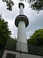
New goose neck tower with viewing platform


history
The goose neck, the location of a number of strange sagas and stories, is also called Geissenberg or Geisberg in ancient sources .
The area on the Goose Neck and its surroundings, which is richly structured by depressions, knolls and valley cuts , has many field names: Am stumpfen Kreuz , Auf dem Sommerberg , Auf der Zwei , Boder , Carfinkental , Die Stiefel , Eselsmorgen , In der Diebeshöhle , In der Königsdelle , in the bull , Kappiche Lay , top of the den of thieves , Nappertal , paradise , Poterberg , Schänzchen , Scheibiger Büsch and low clamp ; some syllables of these names suggest Celtic origin.
East over the ridge of the goose neck ran a Landwehr in the Middle Ages , a building to fortify the border, whose moat and wall remains are still visible in some places.
On the goose neck in 1844 in the corridor near the summit, the remains of a tower known by oral tradition were found on the Sommerberg . When and by whom it was built is not clear. A part of the cemetery wall in Bell, which was erected between 1846 and 1848 and still exists today, was built from the tuff ashlar of the former tower.
Traffic and walking
About 2.5 km northeast of the goose neck, west of the Laacher See , branches off the federal highway 61 at the junction Wehr, the federal highway 412 , which leads a little north of the mountain approximately in an east-west direction to Kempenich . State road 82, which leads south to Bell , runs directly west of the junction on a bridge over the B 412 . From this street in Bell the Gänsehalsstraße branches off, which after leaving the village as a road past the Herreskreuz (with a parking lot near a 401.9 m high waypoint) to the parking lot in the Stier (near a 515.8 m high waypoint ) runs. About 3.5 km west-north-west of the Wehr junction , the B 412 leads on a bridge over the L 114 ( Weibern –Wehr), from which the district road 64 (Ahrweiler district) branches off to the south-west of the bridge ; The latter leads as K 19 (Mayen-Koblenz district) west past the mountain and approximately south to Rieden . The 14.2 km long Rieden Forest Lake Trail (Traumpfad Riedener See) runs over the mountain .
Trivia
There are several amateur radio relay stations on the goose neck .
Individual evidence
- ↑ a b c d e Map services of the Federal Agency for Nature Conservation ( information )
- ↑ Heinz Fischer, Richard Graafen: Geographical land survey: The natural space units on sheet 136/137 Cochem. Federal Institute for Regional Studies, Bad Godesberg 1974. → Online map (PDF; 5.6 MB)
- ↑ a b c d e Chronicle “Bell am Laacher See” ( memento of the original from August 18, 2017 in the Internet Archive ) Info: The archive link was inserted automatically and has not yet been checked. Please check the original and archive link according to the instructions and then remove this notice. (Timetable), on bell-eifel.de
- ↑ a b c d e The goose neck storm at Bell ( Memento of the original from August 18, 2017 in the Internet Archive ) Info: The archive link was inserted automatically and has not yet been checked. Please check the original and archive link according to the instructions and then remove this notice. , on bell-eifel.de
- ↑ Map service of the landscape information system of the Rhineland-Palatinate nature conservation administration (LANIS map) ( notes )
- ↑ The large Landgraben - district boundary in the mirror of history , on Kreis-ahrweiler.de
- ↑ PRGM eV - Presentation - History. Retrieved May 2, 2020 .
Web links
- All-round view from the Gänsehalsturm (labeling of visual targets can be activated), on panorama-photo.net