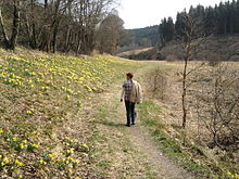
Perlenbachtal
As Perlenbach (also Perlbachtal called) that in is Belgium and Germany in the Eifel located valley of the Roer -Zuflusses Perlenbach designated in which - two culturally and historically prominent German - on the border of the two states nature reserves with a total of 398 hectares lying area.
Perlenbach
The Perlenbach, called Schwalmbach in East Belgium , arises from several source streams and tributaries, which mainly arise in the area of the Belgian military training area Elsenborn near Rocherath ( province of Liège ). Still called Schwalmbach there, it is made up of the rivulets Schwalmbach, Krockesbach, Kranbach, Drosbach, Lienbach, Büllingerbach (or Fuhrstbach), Wolfsbach and Heisterbach. From the confluence with the Heisterbach it is called Perlenbach. It flows northwards, is dammed in the Perlenbachtalsperre and flows into the Rur in Germany, west of Monschau ( North Rhine-Westphalia ) in the Aachen city region . Its water is mainly used to obtain drinking water from the reservoir and the connected waterworks.
Nature reserves
There are two nature reserves in the Perlenbachtal (NSG; with CDDA number, year of designation and area in hectares ):
- Upper NSG: Perlenbach-Fuhrtsbachtal valley system (No. 82312; 1976; 339 ha)
- Lower NSG: Lower Perlenbachtal with the rock formations of the Teufelsley, Engelsley, Bromelsley and Pferdeley (No. 319245; 1997; 59 ha)
Cultural history
The valley owes its name to the river pearl mussel , which used to be at home here with colonies covering the river bed. Today it is considered almost extinct here too. Only a few ancient specimens have been preserved in a hidden place that is only made known to scientists because of the risk of negligent destruction.
By means of a pearl shelf , the pearl mussels were only allowed to be used commercially from 1668 to 1880 by the prince of the Duchy of Jülich , through the pearl fisherman Benedikt Ossenbruch, who was appointed by him. In order to adequately deter secret “wild fishing”, a gallows was specially erected in 1746 on the “Galgendamm”, which can still be found today. It is not known whether “pearl robbers” were actually put to death there. After the occupation of the country by Napoleonic troops, the pearl shelf was lifted and the shells of greed and overexploitation were increasingly delivered. Dating from 1880, historical sources testify that a Monschauer producer did carry away carts as pearl oysters, but there is very little erräuberte yield of black freshwater pearls. A restaurant “Amgericht” continues to bear witness to the local history.
The nutrient-poor meadows of the Bachtal were used for centuries to produce hay, whereby the annual nutrient losses of the soil as a result of the hay production were compensated for by means of irrigation fertilization ( meadow irrigation ). For this purpose, small trenches were dug, so-called Flüxgräben, which led the stream water with its mineral and organic suspended matter onto the hay meadows, which were mostly in the lower slope areas. The irrigation water with its suspended matter made it possible to increase the amount of nutrients available in the soil. In addition, the soil temperature increased slightly, which accelerated the snowmelt in spring and thus locally extended the growing season.
This ancient form of economy was practiced until modern, intensified agriculture gave up remote fields as uneconomical. Instead, mainly fast-growing spruces were planted in order to still achieve economic benefits. Only when homeland and nature conservationists became active within the framework of the German-Belgian nature park Hohes Venn-Eifel brought a turning point. The North Rhine-Westphalia Foundation bought large areas for nature conservation. In subsidized maintenance programs, farmers resumed traditional mowing to preserve these meadow biotopes , where millions of wild daffodils now bloom every spring, attracting crowds of tourists for a few weeks.
Perlenbach dam
In the transition area from the upper to the lower nature reserve, the Perlenbach flows into the Perlenbachtalsperre . Its dam was built from 1953 to 1956 as a rock dam with an asphalt outer skin. The reservoir has a maximum capacity of 0.8 million m³. It serves to secure the water supply in the Aachen - Düren area.
literature
- Emil Pauls : Pearl fishing in the Perlenbach near Montjoie . In: The Hermit on the High Fens . 4th year, no. 2 . Monschau November 1928, p. 23–28 ( Digital Collections of the University of Cologne [accessed on August 9, 2015]).
Web links
Individual evidence
- ↑ Waterworks Perlenbach - overview map of the catchment area ( Memento from March 5, 2016 in the Internet Archive ), on wasserwerk-perlenbach.de (PDF; 123 kB)
- ↑ Water supply association Perlenbach , on wasserwerk-perlenbach.de
- ↑ Map services of the Federal Agency for Nature Conservation ( information )
- ↑ Bodo M. Möseler, Bruno P. Kremer: The Perlenbachtal in Monschauer Heckenland. (= Rhenish landscapes. Issue 56). Edited by the Rheinischer Verein für Denkmalpflege und Landschaftsschutz, Cologne 2006, ISBN 3-86526-002-0 , p. 12ff.
Coordinates: 50 ° 30 ′ 43.4 " N , 6 ° 14 ′ 59.1" E


