
Ralingen
| coat of arms | Germany map | |
|---|---|---|

|
Coordinates: 49 ° 48 ' N , 6 ° 31' E |
|
| Basic data | ||
| State : | Rhineland-Palatinate | |
| County : | Trier-Saarburg | |
| Association municipality : | Trier country | |
| Height : | 160 m above sea level NHN | |
| Area : | 27.64 km 2 | |
| Residents: | 2103 (Dec. 31, 2019) | |
| Population density : | 76 inhabitants per km 2 | |
| Postal code : | 54310 | |
| Area code : | 06585 | |
| License plate : | TR, SAB | |
| Community key : | 07 2 35 111 | |
| Community structure: | 6 districts | |
| Association administration address: | Gartenfeldstrasse 12 54295 Trier |
|
| Website : | ||
| Local Mayor : | Alfred Wirtz (Alliance 90 / The Greens) | |
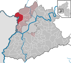
| Location of the local community Ralingen in the district of Trier-Saarburg | ||
  |
||

Ralingen ( Luxembourgish Rooljen ) is a municipality in the Rhineland-Palatinate district of Trier-Saarburg . It belongs to the Trier-Land community .
geography
location
Ralingen is located between Trier and Bitburg an der Sauer directly on the Luxembourg border. The Luxembourg municipality of Rosport is on the opposite side of the Sauer .
Community structure
The community is divided into six districts or districts and a number of places to live (population on May 31, 2020):
| District | Associated living spaces | Residents |
|---|---|---|
| Edingen | Edingerberg, Klingerbach, Kömbchen, Läschhof, Muckenbach | 283 |
| Godendorf | 336 | |
| Kersch | Kerscher Bach | 119 |
| Olk | 429 | |
| Ralingen | Berghof, Dischelt, Georgsmühle, Kunkelborn, Mahlendorf, Merteshof, Ralinger Mühle, Reitzmühle, sheep farm | 475 |
| Winter village | Wintersdorferberg | 492 |
| total | 2134 |
history
On March 17, 1974, the four previously independent communities Edingen, Kersch, Olk and Wintersdorf were incorporated into Ralingen. The community Edingen was formed on June 1, 1972 from the dissolved communities Edingen and Godendorf.
The place Ralingen belonged to the Luxembourg rule Rosport until the end of the 18th century .
- Population development
The development of the number of inhabitants in relation to today's municipality of Ralingen, the values from 1871 to 1987 are based on censuses:
| year | Residents |
|---|---|
| 1815 | 1,035 |
| 1835 | 1,361 |
| 1871 | 1,530 |
| 1905 | 1,502 |
| 1939 | 2,421 |
| 1950 | 1,762 |
| 1961 | 1,703 |
| year | Residents |
|---|---|
| 1970 | 1,736 |
| 1987 | 1,780 |
| 1997 | 1,973 |
| 2005 | 2,026 |
| 2011 | 2,055 |
| 2017 | 2,077 |
| 2019 | 2,103 |
politics
Municipal council
- Greens : 3
- WGO : 1
- FWG : 4
- Flat share : 3
- CDU : 5th
The municipal council in Ralingen consists of 16 council members, who were elected in a personalized proportional representation in the local elections on May 26, 2019 , and the local mayor .
The distribution of seats in the municipal council:
| choice | CDU | GREEN | FW | WGO | Flat share | total |
|---|---|---|---|---|---|---|
| 2019 | 5 | 3 | 4th | 1 | 3 | 16 seats |
| 2014 | 8th | 2 | 4th | 2 | - | 16 seats |
| 2009 | 8th | - | 5 | 3 | - | 16 seats |
- FW = Free Voters Großgemeinde Ralingen e. V.
- WGO = Voting Community Olk e. V.
mayor
Alfred Wirtz (Bündnis90 / Die Grünen) was elected honorary local mayor on May 26, 2019 with 55.3% of the votes, making him the first green mayor in the Trier-Saarburg district. He replaced the long-time mayor Oswald Disch (CDU) (44.7% of the vote).
Community partnerships
- Rosport , Luxembourg , since 2002
- Velence on Lake Velence , Hungary , since 2002
Infrastructure

traffic
The districts of Wintersdorf, Ralingen, Godendorf and Edingen are all on the Sauertalstrasse B 418 from Trier to Echternach . The district of Olk is located near the B 51 between Trier and Bitburg. The district of Kersch is a little more remote between Olk and Wintersdorf. There is a low-frequency bus connection to all parts of the village through the Moselbahn Verkehrsgesellschaft mbH in the Trier Region Transport Association (VRT).
Ralingen, Wintersdorf and Edingen were train stations on the Nims-Sauertalbahn , a branch of the Eifelbahn , which since 1915 led from Erdorf via Bitburg, Wolsfeld and Irrel to Igel . However, this line was closed in 1968/69 and dismantled soon afterwards. Today, the Sauertal cycle path is largely on the route .
education
There is a primary school and a kindergarten in the main town.
church
See also
Web links
- Website of the municipality of Ralingen
- To search for cultural assets of the local community Ralingen in the database of cultural assets in the Trier region .
- Link catalog on Ralingen at curlie.org (formerly DMOZ )
Individual evidence
- ↑ a b State Statistical Office of Rhineland-Palatinate - population status 2019, districts, municipalities, association communities ( help on this ).
- ↑ State Statistical Office Rhineland-Palatinate (ed.): Official directory of the municipalities and parts of the municipality. Status: January 2019 [ Version 2020 is available. ] . S. 122 (PDF; 3 MB).
- ↑ Population statistics . (PDF) Verbandsgemeinde Trier-Land, June 15, 2020, accessed on July 8, 2020 (residents with main residence as of May 31, 2020).
- ↑ Official municipality directory (= State Statistical Office of Rhineland-Palatinate [Hrsg.]: Statistical volumes . Volume 407 ). Bad Ems February 2016, p. 176 (PDF; 2.8 MB; see footnote 57 on p. 184).
- ↑ State Statistical Office Rhineland-Palatinate: My village, my city. Retrieved July 8, 2020 .
- ^ The Regional Returning Officer Rhineland-Palatinate: Local elections 2019, city and municipal council elections.

Aach | Ayl | Baldringen | Bekond | Notification | Beuren (high forest) | Bonerath | Damflos | Detzem | Ensch | Farschweiler | Fur | Fish | Pine | Franzenheim | Freudenburg | Geisfeld | Greimerath | Grimburg | Gusenburg | Gusterath | Gutweiler | Heddert | Stalling | Herl | Hermeskeil | Hinzenburg | Hinzert-Pölert | Hockweiler | Holzerath | Hedgehog | Irsch | Kanzem | Chasuble | Kastel-Staadt | Kell am See | Kenn | Kirf | Klüsserath | Conc | Cord | Korlingen | Köwerich | Lampades | Langsur | Leiwen | Lunge | Longuich | Lorscheid | Mandern | Mannebach | Mehring | Mertesdorf | Merzkirchen | Morscheid | Naurath (Eifel) | Naurath (forest) | Neuhütten | Newel | Nittel | Upper cheap | Ockfen | Ollmuth | Onsdorf | Osburg | Palzem | Paschel | Pellingen | Pluwig | Pölich | Ralingen | Swift oath | Reinsfeld | Riol | Riveris | Saarburg | Schillings | Schleich | Schoden | Schömerich | Schondorf | Schweich | Serrig | Sommerau | Taben-Rodt | Tawern | Temmels | Thomm | Thörnich | Trassem | Trierweiler | Trittenheim | Vierherrenborn | Waldrach | Waldweiler | Wasserliesch | Wawern | Waves | Welschbillig | Wiltingen | Wincheringen | Zemmer | Zerf | Züsch