Morscheid
| coat of arms | Germany map | |
|---|---|---|

|
Coordinates: 49 ° 44 ' N , 6 ° 45' E |
|
| Basic data | ||
| State : | Rhineland-Palatinate | |
| County : | Trier-Saarburg | |
| Association municipality : | Ruwer | |
| Height : | 282 m above sea level NHN | |
| Area : | 5.48 km 2 | |
| Residents: | 935 (Dec. 31, 2019) | |
| Population density : | 171 inhabitants per km 2 | |
| Postal code : | 54317 | |
| Area code : | 06500 | |
| License plate : | TR, SAB | |
| Community key : | 07 2 35 090 | |
| LOCODE : | DE R44 | |
| Association administration address: | Untere Kirchstrasse 1 54320 Waldrach |
|
| Website : | ||
| Local Mayor : | Josef Weber ( WG Weber) | |
| Location of the local community Morscheid in the district of Trier-Saarburg | ||
Morscheid ( Moselle Franconian : Moatscheld ) is a municipality in the Trier-Saarburg district in Rhineland-Palatinate . It belongs to the Verbandsgemeinde Ruwer , which has its administrative headquarters in Waldrach .
geography
The place is on a ridge of the Osburger Hochwald between the valleys of Ruwer and Riveris . The slate plateau, sloping on three sides and rounded to the north at the confluence of the streams, gives Morscheid an exposed location. Tunnels and pits indicate the former mining of slate and ore .
The steep slope in the northeastern area of the district is planted with vines . This is also where the Marienlay Castle winery (20th century) is located, which characterizes the landscape . The village is situated at an altitude of about 250- 350 m above sea level. NHN . The highest point of the Morscheider area, however, is around 480 m above sea level. NHN .
The residential areas Schloss Marienlay , Im Lonschenberg, Herrgottsmühle, Lichtenthalsmühle and Studentenmühle also belong to Morscheid .
The premium hiking trail Morscheider Grenzpfad runs along the boundary of Morscheid .
history
The first mention in connection with a property of the Archbishop of Trier Poppo von Babenberg (1016-1047) in "Murcid" and the Martinus - patronage of the Catholic parish church suggest an emergence in the Carolingian clearing period.
- Population development
The development of the population of Morscheid, the values from 1871 to 1987 are based on censuses:
|
|
politics
Municipal council
The council in Morscheid consists of twelve council members, who in the local elections on May 26, 2019 in a majority vote were elected, and the honorary mayor as chairman.
coat of arms
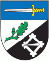
| Blazon : "Under a blue shield head with a silver, gold-hilted sword, divided obliquely by silver over black, above a green oak branch with leaf and acorn, below a diamond-shaped silver belt buckle." | |
| Foundation of the coat of arms: According to a document from Archbishop Poppo von Babenberg (1016-1047) of Trier , the "Murcid" estate is mentioned. As early as 1430, the Lords of Schmidtburg ( Schenk von Schmidtburg ) appeared as owners of the place. They are the landlords of the village and as such receive dues from each family. They are collators of the Church and receive 2/3 of the total tithe. Your coat of arms: In black, a diamond-shaped, white belt buckle (so-called "rink"), covered with colored stones, is depicted here in a reduced form. The Martinus patronage is symbolized by the rendering of its attribute, a sword. As a reference to the oak groves of Morscheid, there is an oak leaf with an acorn in the middle shield. |
Culture and clubs
Several associations are active in various areas of society.
Infrastructure
In Morscheid there is a community center, a sports facility and a daycare center.
See also
Web links
- Website of the local community Morscheid
- To search for cultural assets of the local community Morscheid in the database of cultural assets in the Trier region .
- Link catalog on the subject of Morscheid at curlie.org (formerly DMOZ )
Individual evidence
- ↑ State Statistical Office of Rhineland-Palatinate - population status 2019, districts, communities, association communities ( help on this ).
- ↑ State Statistical Office Rhineland-Palatinate (ed.): Official directory of the municipalities and parts of the municipality. Status: January 2019 [ Version 2020 is available. ] . S. 119 (PDF; 3 MB).
- ↑ State Statistical Office Rhineland-Palatinate: Regional data.


