
Ollmuth
| coat of arms | Germany map | |
|---|---|---|

|
Coordinates: 49 ° 40 ' N , 6 ° 43' E |
|
| Basic data | ||
| State : | Rhineland-Palatinate | |
| County : | Trier-Saarburg | |
| Association municipality : | Ruwer | |
| Height : | 330 m above sea level NHN | |
| Area : | 3.92 km 2 | |
| Residents: | 156 (Dec 31, 2019) | |
| Population density : | 40 inhabitants per km 2 | |
| Postal code : | 54316 | |
| Area code : | 06588 | |
| License plate : | TR, SAB | |
| Community key : | 07 2 35 100 | |
| Association administration address: | Untere Kirchstrasse 1 54320 Waldrach |
|
| Website : | ||
| Local Mayor : | Gerd Dietzen | |
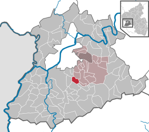
| Location of the local community Ollmuth in the district of Trier-Saarburg | ||
  |
||


Ollmuth is a municipality in the district of Trier-Saarburg in Rhineland-Palatinate . It belongs to the Verbandsgemeinde Ruwer , which has its administrative headquarters in Waldrach . The place is in the Moselle Franconian language area.
history
The name probably goes back to the Roman name of the earlier settlement ulmetum (Latin for elm forest ).
- Population development
The development of the population of Ollmuth, the values from 1871 to 1987 are based on censuses:
|
|
politics
Municipal council
The local council in Ollmuth consists of six council members, who were elected by majority vote in the local elections on May 26, 2019 , and the honorary local mayor as chairman.
coat of arms
Blazon : "Through an inserted silver tip, inside a green elm leaf, split, in front a silver ploughshare in red, behind in red a golden square measure."
Justification for the coat of arms: The place name goes back to the Latin "ulmus" = elm , "ulmetum" = elm forest. As an indication of this, the coat of arms shows a green elm leaf in the inserted tip. This symbolizes the interpretation of the place name. Ollmuth is still a largely agriculturally structured municipality today. This fact is documented by the inclusion of a ploughshare in the municipal coat of arms. The ancient ploughshare is therefore in the first field of the municipal coat of arms. The chapel built at Ollmuth in 1834 was patronized by the apostle Thomas . He was also the local patron of the community. Its attribute is an angle measure. It is in the heraldic left part of the municipal coat of arms .
Culture and sights
On a hill called "Thomasberg" above Ollmuth there was a church, first mentioned in 1330, which was probably built mainly in the Gothic style. However, the church was destroyed in 1794 after its roofs had burned down in 1648 at the end of the Thirty Years War . At that time, Ollmuth and Franzenheim in the opposite valley formed a common parish . Since its destruction, both communities have had their own churches in the village (in Ollmuth the baroque St. Thomas Church from 1834), so that the place is now a desert . In the immediate vicinity there is also a small chapel with a view over the Ruwertal and towards Pellingen .
There are several listed crosses in the village and its area.
In 2016 Ollmuth was the scene of a special stage of the Rally Germany .
See also
Web links
- Internet presence of the local community Ollmuth
- Link catalog on the subject of Ollmuth at curlie.org (formerly DMOZ )
- To search for cultural assets of the local community Ollmuth in the database of cultural assets in the Trier region .
Individual evidence
- ↑ a b State Statistical Office of Rhineland-Palatinate - population status 2019, districts, municipalities, association communities ( help on this ).
- ↑ State Statistical Office Rhineland-Palatinate - regional data
- ↑ Entry on the former church on the Thomasberg near Ollmuth in the database of cultural assets in the Trier region ; accessed on July 27, 2017.
- ↑ Entry on St. Thomas Chapel in the database of cultural assets in the Trier region ; accessed on July 27, 2017.
- ^ Entry on St. Thomas in Ollmuth in the database of cultural assets in the Trier region ; accessed on July 27, 2017.

Aach | Ayl | Baldringen | Bekond | Notification | Beuren (high forest) | Bonerath | Damflos | Detzem | Ensch | Farschweiler | Fur | Fish | Pine | Franzenheim | Freudenburg | Geisfeld | Greimerath | Grimburg | Gusenburg | Gusterath | Gutweiler | Heddert | Stalling | Herl | Hermeskeil | Hinzenburg | Hinzert-Pölert | Hockweiler | Holzerath | Hedgehog | Irsch | Kanzem | Chasuble | Kastel-Staadt | Kell am See | Kenn | Kirf | Klüsserath | Conc | Cord | Korlingen | Köwerich | Lampades | Langsur | Leiwen | Lunge | Longuich | Lorscheid | Mandern | Mannebach | Mehring | Mertesdorf | Merzkirchen | Morscheid | Naurath (Eifel) | Naurath (forest) | Neuhütten | Newel | Nittel | Upper cheap | Ockfen | Ollmuth | Onsdorf | Osburg | Palzem | Paschel | Pellingen | Pluwig | Pölich | Ralingen | Swift oath | Reinsfeld | Riol | Riveris | Saarburg | Schillings | Schleich | Schoden | Schömerich | Schondorf | Schweich | Serrig | Sommerau | Taben-Rodt | Tawern | Temmels | Thomm | Thörnich | Trassem | Trierweiler | Trittenheim | Vierherrenborn | Waldrach | Waldweiler | Wasserliesch | Wawern | Waves | Welschbillig | Wiltingen | Wincheringen | Zemmer | Zerf | Züsch