
Kastel-Staadt
| coat of arms | Germany map | |
|---|---|---|

|
Coordinates: 49 ° 34 ' N , 6 ° 34' E |
|
| Basic data | ||
| State : | Rhineland-Palatinate | |
| County : | Trier-Saarburg | |
| Association municipality : | Saarburg-Kell | |
| Height : | 330 m above sea level NHN | |
| Area : | 5.26 km 2 | |
| Residents: | 433 (Dec. 31, 2019) | |
| Population density : | 82 inhabitants per km 2 | |
| Postal code : | 54441 | |
| Area code : | 06582 | |
| License plate : | TR, SAB | |
| Community key : | 07 2 35 057 | |
| Community structure: | 2 districts | |
| Association administration address: | Schloßberg 6 54439 Saarburg |
|
| Website : | ||
| Local Mayor : | Reiner Schmitt | |
| Location of the local community Kastel-Staadt in the district of Trier-Saarburg | ||
  |
||


Kastel-Staadt is a municipality in the Trier-Saarburg district in Rhineland-Palatinate . It belongs to the Saarburg-Kell association.
Geographical location
Kastel is located on a rock plateau high above the Saar . The district of Staadt in the Saar valley opposite Serrig belongs to the local community . The place is about nine kilometers north of the Saarland Mettlach and four kilometers south of Saarburg and is connected to the national road network by the state road 131 .
Kastel-Staadt also includes Neufels and Staadt.
history
At Kastel-Staadt there was an oppidum of the Treveri . The Romans probably built an almost impregnable fort on the high plateau before the turn of the century . Finds from the Celtic and Roman times are documented in large numbers in the vicinity. During excavations between 2006 and 2008, a Roman theater with 34 rows of seats in a semicircle and seating for over 3,000 spectators was discovered on the plateau of Kastel-Staadt. Since 2013, the facility has been freely accessible with a view of the Saar Valley. The place Kastel was first mentioned in a document in 1098.
On July 18, 1946, Kastel-Staadt, together with 80 other municipalities in the districts of Trier and Saarburg , was annexed to the Saar area , which was separated from the rest of the French occupation zone in February 1946 and which was no longer under the Allied Control Council at the time . On June 6, 1947, this territorial outsourcing was withdrawn to 21 municipalities, so that Kastel-Staadt came to the 1946 newly formed state of Rhineland-Palatinate .
population
The development of the population of Kastel-Staadt, the values from 1871 to 1987 are based on censuses:
|
|
|
Data source: State Statistical Office of Rhineland-Palatinate
Municipal council
The local council in Kastel-Staadt consists of eight council members, who in the local elections on May 26, 2019 in a majority vote were elected, and the honorary mayor as chairman.
Worth seeing
The Klause Kastel is a refuge carved into the sandstone rock wall by monks on a plateau above the Saar valley .
Not far from the hermitage is a natural fortification ( oppidum ) already settled by the Celts and protected from enemies on three sides by red sandstone and on the fourth with a wall .
Above the hermitage is the Kastel cemetery of honor for the fallen of the Second World War .
Near the hermitage is the old church of St. John the Baptist , which was a parish church with a wide catchment area until 1442. Its tower dates from the 12th century and the nave from the 13th century.
The Kasteler Felsenpfad dream loop is a premium hiking trail that meanders around the plateau.
See also: List of cultural monuments in Kastel-Staadt

Klause with rock chapels and burial chapel

Interior view of the burial chamber

Pedigree on the west wall of the burial chamber

Old parish church St. Johannes dT
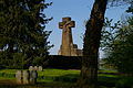
Main cross at the Kastel cemetery of honor
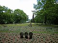
Kastel Cemetery of Honor
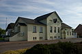
Schinkel School from 1840


Design of the environment by Schinkel

The church stands in the middle of a cemetery, the surrounding wall of which was designed by Karl Friedrich Schinkel . A Pietà can be seen above the entrance to the cemetery .
Schinkel also designed the burial chapel for Johann von Böhmen , which Friedrich Wilhelm IV commissioned. It is located in the immediate vicinity of the Church of St. John the Baptist . Schinkel used the ruins of the Kastel Klause , which was built around 1600 and passed into the possession of Friedrich Wilhelm IV in 1833. The body of Johann von Böhmen, which Friedrich Wilhelm IV had received from Jean-François Boch in Mettlach , has been in Luxembourg since 1946 ; the classicist sarcophagus has been empty since then. In gratitude for the donation of the bones of Johann von Böhmen, Friedrich Wilhelm IV. Presented Boch with a fountain, the figure of which was designed by Schinkel.
The burial chapel is one of Schinkel's important late works and is considered an important testimony to neo-Romanesque neo-classical art. Schinkel refrained from changing the preserved ground floor of the ruin with its gothic cross-ribbed vault from the 17th century, and only provided colorful window glazing. He designed the new masonry according to the pattern of the existing one. The upper floor was provided with a round arch frieze and windows in the form of triple arcades; An Italian-style bell gable was placed on the north side.
In the immediate vicinity of the Church of St. John the Baptist , Schinkel also created the viewing point "Elisensitz" at the favorite place of Crown Princess Elisabeth of Bavaria . The so-called Schinkel School was also built in the town in 1840, although it may not have been planned by Schinkel himself.
economy
In addition to the various small businesses and services, mainly agriculture, viticulture and fruit growing for the Viez is practiced in the village . As in other places in the region, hiking trails offer nature-loving tourists numerous excursion options.
Personalities
- The writer Arno Schmidt lived in Kastel from December 3, 1951 to September 23, 1955.
- The Romanist Peter M. Already was born in Kastel-Staadt in 1912.
literature
- Josef Huerkamp: The landscapist on the heights. Arno Schmidt in Kastel 1951–1955 . Neisse Verlag, Dresden 2008.
- Alice Schmidt : Diary from 1954 . Suhrkamp, Frankfurt am Main 2004.
- Alice Schmidt: Diary from 1955 . Suhrkamp, Frankfurt am Main 2008.
Web links
- Kastel-Staadt on the website of the Saarburg-Kell association
- To search for cultural assets of the local community Kastel-Staadt in the database of cultural assets in the Trier region .
- The Kastel-Staadt oppidum
- Castell in the Saarburg district and some previous owners of the same, in particular King John of Bohemia, Count of Luxembourg, by Georg Baersch (1839)
- Castel (Clause) near Saarburg from Panorama of Trier and its surroundings (around 1840) via dilibri
- Link catalog on the topic of Kastel-Staadt at curlie.org (formerly DMOZ )
- Anna-Sophie Buchhorn: Kastel-Staadt - Celtic oppidum and Roman vicus. (PDF) New results on the history of settlement.
Individual evidence
- ↑ State Statistical Office of Rhineland-Palatinate - population status 2019, districts, communities, association communities ( help on this ).
- ↑ State Statistical Office Rhineland-Palatinate (ed.): Official directory of the municipalities and parts of the municipality. Status: January 2019 [ Version 2020 is available. ] . S. 124 (PDF; 3 MB).
- ^ Roman theater Kastel-Staadt
- ↑ State Statistical Office Rhineland-Palatinate: My village, my city. Retrieved July 17, 2019 .
- ^ Hermann Pütz: On shoemaker's pony to Altfels . Trierischer Volksfreund , May 2, 2010.
- ^ The Kastel-Staadt cemetery of honor. (No longer available online.) April 22, 2005, archived from the original on September 14, 2015 ; Retrieved October 31, 2015 (private website).
- ↑ Former royal grave on the Saar. Klause near Kastel. (No longer available online.) Saar and Mosel online portal, archived from the original on March 4, 2016 ; Retrieved October 31, 2015 (private website).
- ↑ Mettlach - Schinkelbrunnen ( Memento from February 12, 2013 in the web archive archive.today )
- ↑ viewpoint Elise seat in Kastel-Staadt. (No longer available online.) Saar and Mosel online portal, archived from the original on December 1, 2015 ; Retrieved October 31, 2015 (private website).
- ↑ Kastel-Staadt - Schinkel School ( Memento from September 12, 2012 in the web archive archive.today )

Aach | Ayl | Baldringen | Bekond | Notification | Beuren (high forest) | Bonerath | Damflos | Detzem | Ensch | Farschweiler | Fur | Fish | Pine | Franzenheim | Freudenburg | Geisfeld | Greimerath | Grimburg | Gusenburg | Gusterath | Gutweiler | Heddert | Stalling | Herl | Hermeskeil | Hinzenburg | Hinzert-Pölert | Hockweiler | Holzerath | Hedgehog | Irsch | Kanzem | Chasuble | Kastel-Staadt | Kell am See | Kenn | Kirf | Klüsserath | Conc | Cord | Korlingen | Köwerich | Lampades | Langsur | Leiwen | Lunge | Longuich | Lorscheid | Mandern | Mannebach | Mehring | Mertesdorf | Merzkirchen | Morscheid | Naurath (Eifel) | Naurath (forest) | Neuhütten | Newel | Nittel | Upper cheap | Ockfen | Ollmuth | Onsdorf | Osburg | Palzem | Paschel | Pellingen | Pluwig | Pölich | Ralingen | Swift oath | Reinsfeld | Riol | Riveris | Saarburg | Schillings | Schleich | Schoden | Schömerich | Schondorf | Schweich | Serrig | Sommerau | Taben-Rodt | Tawern | Temmels | Thomm | Thörnich | Trassem | Trierweiler | Trittenheim | Vierherrenborn | Waldrach | Waldweiler | Wasserliesch | Wawern | Waves | Welschbillig | Wiltingen | Wincheringen | Zemmer | Zerf | Züsch