
Thomm
| coat of arms | Germany map | |
|---|---|---|

|
Coordinates: 49 ° 45 ' N , 6 ° 48' E |
|
| Basic data | ||
| State : | Rhineland-Palatinate | |
| County : | Trier-Saarburg | |
| Association municipality : | Ruwer | |
| Height : | 462 m above sea level NHN | |
| Area : | 4.49 km 2 | |
| Residents: | 1066 (Dec. 31, 2019) | |
| Population density : | 237 inhabitants per km 2 | |
| Postal code : | 54317 | |
| Area code : | 06500 | |
| License plate : | TR, SAB | |
| Community key : | 07 2 35 135 | |
| Association administration address: | Untere Kirchstrasse 1 54320 Waldrach |
|
| Website : | ||
| Local Mayor : | Stephan Seeling | |
| Location of the local community Thomm in the district of Trier-Saarburg | ||
  |
||


Thomm (from Latin tumba = burial mound , Moselle Franconian : [ tom ]) is a municipality in the district of Trier-Saarburg in Rhineland-Palatinate . It belongs to the Verbandsgemeinde Ruwer , which has its administrative headquarters in Waldrach .
Thomm is located in the Upper Osburger Hochwald on Landesstrasse 151 (formerly Bundesstrasse 52 , exits Osburg-Neuhaus and Neuhinkelhaus ) between Trier and Hermeskeil . Thomm is known for a good viez ( apple wine ) and its mining tradition (along with fur ).
geography
Geographical location
The district of Thomm lies in the front Osburger Hochwald, the so-called Osburger Hunsrück , and is surrounded to the east and north by the Thommerbach , which flows into the Moselle via the Feller Bach . To the southwest, the district drains via the Rotelbach and Bausbach to the Riveris , which also flows over the Ruwer to the Moselle.
Parts of the municipality are Althinkelhaus , Neuhinkelhaus and Thommerberg . The Thommer Mühle on Thommerbach existed until the 1920s.
The main field names of Thomm are An der Köpp , Brasilienberg , Jauch , Kirchhuf , Klausberg and Heßler . The Brazil Mountain was once a meeting point for emigrants to Brazil .
The streets in Thomm are Altenweg, Auf der Heide, Auf der Persch, Barbaraweg, Bergmannsweg, Borngasse, Fahrtweg, Feldstraße, Feller Straße, Höhenstraße, Im Eichenbungert, Kapellenstraße , Kirchstraße , Lorengasse, Martinstraße, Mühlweg, Neu-Hinkelhaus , Neuenweg, Osburger Weg, Richtgasse, Ringstrasse, Römerstrasse, Ruwertalblick, Auf den Schiefergruben , Schmiedegasse, Schulstrasse, Sommergasse, Theisbungert, Trierer Strasse , Waldracher Weg, Zum Hügel and Zur Schönen Aussicht.
Neighboring municipalities
Neighboring communities are clockwise (starting in the north): Fell , Herl , Farschweiler , Osburg and Waldrach .
geology
In the district, the Grauwackenzone of the Osburger Hochwald is being replaced by clay and slate.
history
The area around Thomm and Osburg was probably settled more than 2000 years ago, what has been found of objects and building residues, also of Celtic origin, such as B. the princely grave of Thomm , document. Hinkelstein is still the name of the menhir today , probably from the late Neolithic period, which stands in the open on a dirt road 1 km west of Thomm, a little to the right off the state road 151 from Hermeskeil to Trier . It consists of almost white quartz and has the shape of a slender pyramid. The new and nearby old Hinkelhaus , which was destroyed by fire in the 1960s, take their names from him.
Thomm is mentioned for the first time in Trier's oldest city law around 1190. Residents of Waldrach, Thomm, Riveris, Osburg, Reinsfeld, Kell, Wiltingen, Kanzem, Filzen, Könen, Konz, Wasserliesch, Reinich, Zewen, Ober- and Niederkirch, Euren, Trierweiler u. a. were obliged to clean the Trier Stadtbach annually in return for market and customs relief. An undated document dates from around 1217, with which the cruising knights Peter von Merzig and Friedrich von der Brücke pledge the Hunria jurisdiction they are entitled to in Osburg, Waldrach, Thomm and Riveris to the Archbishop Theoderich of Trier . Thomm is also mentioned in the Liber annalium iurium of the Archbishop of Trier around 1220 . Another documentary mention is made in 1329 in a leaning lapel of those of Oeren. In the following year a church is mentioned in the Taxa generalis of the Archdiocese of Trier . The patronage and the tithe were a Kurtrierisches fief, which is part of the electoral taverns Office was. In 1538 the fief came from the Schenk von Schmidtburg to the barons and later imperial counts of Kesselstatt and remained there until the Napoleonic era.
The place developed as follows: in the Trier fire book of 1563 there are 16 fireplaces, in 1684 only 12. With the start of slate mining near the place, the number of inhabitants increased from 229 in 1787 to 327 in 1818. 1978 it was 877 inhabitants and in 1998 more than 1000. In 1788 Thomm received a new church; In 1964, a new church was built according to plans by the Trier architect Heinrich Otto Vogel . When the old church was built in 1964, only the bell tower and the outer wall, which had been removed down to a floor plan, remained. The new church was consecrated on August 28, 1965 by the Trier auxiliary bishop Carl Schmidt .
From 1778 to 1978 there were schools in Thomm . A list of teachers is documented from 1817 to 1978. In 1978, the first school enrollment took place in what was then the central school in Osburg.
In March 1945, Thomm was largely destroyed in the Second World War. During the Allied air raids , the population sought protection in the slate pits near the village. On March 17, 1945 the Americans marched into Thomm. A war memorial was erected near the old church for those who died in the two world wars .
The beginnings of the church choir Cäcilia are in the dark, an existing church choir was first mentioned in 1895. In 1920 the men's choir was founded, in 1925 the volunteer fire brigade , in 1927 the miners' band Glück Auf and in 1929 the sports club Glück Auf . There have been youth organizations in Thomm since 1969 . In 1987 the Heimat- und Verkehrsverein is founded.
From 1971 to 2011, the Trier hill climb took place annually on Kreisstraße 82 between Fell and Thomm , which was part of the European Hill Climb Championship . Special stages of the Germany Rally have been held on the same route since 2000 (with interruptions) .

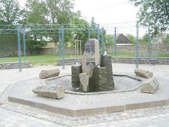
In 2005, after two years of construction, the expansion of the district road and the redesign of the village squares will be celebrated with a large village festival and the new village fountain with the historic stones will be inaugurated. In 2007, the Osburg-Thomm football team was promoted to the regional league of the Rhineland Football Association and held this league until 2017. In 2009, Thomm hosted the 15th district youth fire brigade camp of the Trier-Saarburg district youth fire brigade association with around 600 participating young people. The new artificial turf sports field will be handed over at the 2010 Sports Festival .
In December 2010, a working group of the Heimat- und Verkehrsverein was set up, which, with the support of the Thomm parish, has set itself the goal of creating a village chronicle . On December 22, 2012, a Christmas market will take place for the first time in Thomm on the new village square by the old church tower, organized by the miners' chapel and other interest groups.
On August 8, 2015, the Thomm youth club organized the benefit concert Lautstark against cancer with over 1000 visitors on the fairground at the community center. From August 29th to 31st, 2015, the 50th anniversary of the consecration of the new Thommer Church will be celebrated together with the fair and the parish festival. On this occasion, the 140-page book 50 Years Parish Church St. Pauli Conversion Thomm was published, published by the Thomm Heimat- und Verkehrsverein Thomm in cooperation with the parish and local community of Thomm.
The road bike race Deutschland Tour 2018 also leads through Thomm with the 2nd stage Bonn-Trier. In 2019, Thomm will again host the 19th district youth fire brigade tent camp of the district youth fire brigade association Trier-Saarburg with around 550 participating young people.
Population development
The development of the population of Thomm, the values from 1871 to 1987 are based on censuses:
|
|
Graphic of the population development

|
religion
In the 2011 census , 86% of the population were Catholic and 6% Protestant. The local Catholic parish of St. Pauli Conversion in the Hermeskeil-Waldrach deanery belongs to the Trier diocese . The Evangelicals are assigned to the Evangelical Church Community of Ehrang and the Evangelical Church in the Rhineland .
politics
By the end of the 18th century belonged to Thomm care Waldrach the kurtrierischen Office Pfalzel . It then came to the French Mairie Farschweiler and in 1816 to the Prussian mayor's office in Farschweiler , which was renamed Amt Farschweiler in 1927 . With the places Farschweiler, Herl, Lorscheid and Osburg, Thomm came to the Waldrach Office in Ruwer in 1934 , which was named Amt Ruwer in 1954 and became the Verbandsgemeinde Ruwer in 1968 , which moved the administrative headquarters from Trier-Ruwer to Waldrach in 2005 .
Municipal council
The local council in Thomm consists of 16 council members who were elected in a personalized proportional representation in the local elections on May 26, 2019 , and the honorary local mayor as chairman.
The distribution of seats in the local council:
| choice | SPD | CDU | Flat share | total |
|---|---|---|---|---|
| 2019 | 6th | 3 | 7th | 16 seats |
| 2014 | 7th | - | 9 | 16 seats |
| 2009 | 6th | - | 10 | 16 seats |
| 2004 | 7th | - | 9 | 16 seats |
| 1999 | 5 | - | 7th | 12 seats |
Community head / mayor
- around 1846: Mathias Prüm
- Johann Michels
- Peter Gotten
- 1931: Resch
- 1933: Joh. Zingerling-Krämer
- Matthias Krempchen
- 1946–1948: Josef Matthias Michels
- 1948–1952: Matthias Berens-Mattes
- 1952–1964: Matthias Krempchen
- 1964–1992: Gerhard Müller ( honorary citizenship of the local community granted in 2005)
- 1993–2009: Otmar Brittner
- 2009–2019: Hans-Peter Michels
- from 2019: Stephan Seeling
Coat of arms and municipal flag
|
|
Blazon : "Under a silver shield head, inside a blue sword with a golden hilt, a rising silver tip in red, covered with a black hammer and mallet." |
| Establishment of the coat of arms: Until around 1800, Thomm was part of the Electorate of Trier . This is indicated by the field colors silver and red. Church and site patron of Thomm is St. Paul . His attribute, the sword, is in the shield head of the coat of arms. The so-called " Hinkelstein ", a natural and cultural monument, is located directly at Thomm . It is symbolized by the silver tip in the lower part of the shield. The Thommer Schiefergruben were well known for centuries. Only recently has mining been abandoned. As a reminder, there are hammer and mallet, the symbols of the miner. |
The local community Thomm carries a community flag in the colors red and white with the community coat of arms .
Culture and sights

The angelus ringing of the church bells takes place three times a day. On Epiphany , the three wise men symbolically move through the town. The custom of rasping is cultivated on the Kartagen . In May there is a Marian procession in Thomm and on Corpus Christi , a Corpus Christi procession alternates with neighboring towns. To the St. Martin in November is St. Martin's procession performed.
Well worth seeing is the Thommer Christmas crib , which has been built in the new church by the Thomm crib builders since 1975 . The biblical motifs, the village of Thomm and the surrounding area are shown on over 40 m².
A replica of the Margarethenstollen entrance was built in 2005 at the entrance to the village.
Cultural and natural monuments
Sports
From 2006 to 2014, a 20-hour bike marathon was held around Fell and Thomm every summer .
societies
According to the register of associations of the Wittlich District Court , Thomm has the following registered associations : Bergmannskapelle Glück Auf Thomm, BC Thomm, Förderverein Kunstrasensportplatz Thomm, Heimat- und Verkehrsverein Thomm, Förderverein der Freiwilligen Feuerwehr Thomm eV, Männergesangverein 1920 Thomm (the club is inactive, status: 2006 ) and sports club Glück Auf Thomm. The church choir Cäcilia Thomm, the youth club Thomm and the DTM friends Noßertal are also active. Historically there was also a warrior association or a miners' association in Thomm.
Events
Regular events are:
- Carnival parade followed by a carnival party, organizer: sports club
- Concert by the miners 'band, organized by the miners' band
- May hike to the Jungewaldhütte, organized by: Bergmannskapelle
- Open day, organizer: volunteer fire brigade
- Sports festival, organizer: sports club
- Fair and parish festival, local associations and parish
- Viezfest, organizer: Bergmannskapelle
- Autumn hike, organized by: Heimat- und Verkehrsverein
- Theater performances by the theater group of the Heimat- und Verkehrsverein
Economy and Infrastructure
In Thomm there are two agricultural enterprises, several small and medium enterprises , a branch of the Volksbank Trier and a self-service centers of the Sparkasse Trier .
The Keizer von Thomm was a well-known bus travel company from Thomm.
Land use : The total land area is 4.49 km², of which 45.4% agricultural area, 33.5% forest area, 0.3% water area, 18.1% settlement and traffic area, 2.8% other areas.
media
Local media are the Trierische Volksfreund , the Mosel-Ruwertaler Wochenspiegel and the official gazette of the Verbandsgemeinde Ruwer .
Public facilities
- Thomm Hunting Association
- Community house (old rectory) with community office and library
- Day care center St. Barbara and integrative day care center Haus Tobias
- Fire station
- Sports field, fairground and community center
- Jungewaldhütte (grill hut)
- Boules court at the village square
traffic
Street
The district road 82 leads from Fell through the village in the direction of Osburg-Neuhaus. It runs through Waldracher Weg, Trierer Straße and Kapellenstraße . The district road 83 leads from the K 82 in the direction of Waldrach. State roads in the municipality are the L 149 and the L 151 (former federal road 52 ). The next motorway junctions are at Reinsfeld , Kenn and Moseltaldreieck .
rail
The nearest railway stations are Trier Central , Station Ehrang , Schweich DB Station or Station Türkismühle .
Public transport
Thomm is part of the Trier Region Transport Association and is served by the regional bus lines R 200 ( Trier - Hermeskeil - Türkismühle ) and 202 (Trier - Thomm - Reinsfeld - Hermeskeil).
Hiking trails
A pit hiking trail leads from Thomm to the Fell visitor mine . The Herler Wacken and the Feller Hof are within sight of Thomm, and the Schiefer-Wackenweg leads there . The hiking trails Tm 1, Tm 2 and RT 2 signposted through the Saar-Hunsrück Nature Park lead to various destinations around Thomm.
Personalities
- Peter Schnepp (* 1911, † 2011 in Boppard ), long-time pastor of Thomm; under his direction the new Thommer Church was built in 1964;
- Günter Mattes, holder of the badge of honor of the state of Rhineland-Palatinate
- Ludwig Zöller , geoscientist, lived with his family in Thomm from 1979 to 1985;
- Helmut Scherf, engineer ( literature )
- Alfred Michels, long-time military leader, holder of the silver fire brigade badge of honor on ribbon
- Mechthild Michels, archaeologist ( literature )
- Raimund Brittner (* 1963), soccer player
- Anja Brittner-Widmann, geographer ( literature )
photos

Menhir

Tumulus
New village well

Sculpture at the southern entrance to the town

church

House of the community


literature
- Ralf Hansjosten: Non nobis sed posteris. History of the mining communities Fell and Thomm. Kliomedia , Trier 2001, ISBN 3-89890-042-8 .
- Tobias Blasum, Hermann Bonert: Fallen fortresses: The end of the Second World War in the Osburger Hochwald and in the Ruwertal. Kieselkaul-Verlag Osburg, 2016. ISBN 978-3-00-054815-4 . The book was also created using material from the Thomm Village Chronicle Working Group.
Web links
- Website of the local community Thomm
- To search for cultural goods of the local community Thomm in the database of cultural goods in the Trier region .
- Link catalog on Thomm at curlie.org (formerly DMOZ )
Individual evidence
- ↑ State Statistical Office of Rhineland-Palatinate - population status 2019, districts, communities, association communities ( help on this ).
- ↑ State Statistical Office Rhineland-Palatinate (ed.): Official directory of the municipalities and parts of the municipality. Status: January 2019 [ Version 2020 is available. ] . S. 120 (PDF; 3 MB).
- ↑ Entry on Im Brasilienberg (Thomm) in the database of cultural assets in the Trier region .
- ↑ strassenkatalog.de
- ^ Hans Hubert Anton , University of Trier: Trier in the Middle Ages , Spee-Verlag, 1996, p. 260
- ^ Church choir Cäcilia Thomm
- ↑ Village Chronicle Working Group
- ^ Dittmar Lauer : 50 years parish church St. Pauli Conversion Thomm. Publishing house Alta Silva, Kell am See 2015.
- ↑ State Statistical Office Rhineland-Palatinate: Regional data.
- ↑ 2011 census
- ^ The Regional Returning Officer Rhineland-Palatinate: Local elections, city and municipal council elections.
- ↑ Coat of arms and community flag of the local community Thomm
- ^ General Directorate for Cultural Heritage Rhineland-Palatinate (ed.): Informational directory of cultural monuments - District of Trier-Saarburg. Mainz 2020, p. 68 (PDF; 6.5 MB).
- ^ Journal of Mining, Metallurgy and Saltworks in the German Empire, Volume 24 (1876)
- ↑ gefallene-festungen.de

Aach | Ayl | Baldringen | Bekond | Notification | Beuren (high forest) | Bonerath | Damflos | Detzem | Ensch | Farschweiler | Fur | Fish | Pine | Franzenheim | Freudenburg | Geisfeld | Greimerath | Grimburg | Gusenburg | Gusterath | Gutweiler | Heddert | Stalling | Herl | Hermeskeil | Hinzenburg | Hinzert-Pölert | Hockweiler | Holzerath | Hedgehog | Irsch | Kanzem | Chasuble | Kastel-Staadt | Kell am See | Kenn | Kirf | Klüsserath | Conc | Cord | Korlingen | Köwerich | Lampades | Langsur | Leiwen | Lunge | Longuich | Lorscheid | Mandern | Mannebach | Mehring | Mertesdorf | Merzkirchen | Morscheid | Naurath (Eifel) | Naurath (forest) | Neuhütten | Newel | Nittel | Upper cheap | Ockfen | Ollmuth | Onsdorf | Osburg | Palzem | Paschel | Pellingen | Pluwig | Pölich | Ralingen | Swift oath | Reinsfeld | Riol | Riveris | Saarburg | Schillings | Schleich | Schoden | Schömerich | Schondorf | Schweich | Serrig | Sommerau | Taben-Rodt | Tawern | Temmels | Thomm | Thörnich | Trassem | Trierweiler | Trittenheim | Vierherrenborn | Waldrach | Waldweiler | Wasserliesch | Wawern | Waves | Welschbillig | Wiltingen | Wincheringen | Zemmer | Zerf | Züsch