Damflos
| coat of arms | Germany map | |
|---|---|---|

|
Coordinates: 49 ° 40 ′ N , 6 ° 59 ′ E |
|
| Basic data | ||
| State : | Rhineland-Palatinate | |
| County : | Trier-Saarburg | |
| Association municipality : | Hermeskeil | |
| Height : | 570 m above sea level NHN | |
| Area : | 5.31 km 2 | |
| Residents: | 620 (Dec. 31, 2019) | |
| Population density : | 117 inhabitants per km 2 | |
| Postal code : | 54413 | |
| Area code : | 06503 | |
| License plate : | TR, SAB | |
| Community key : | 07 2 35 014 | |
| LOCODE : | DE DMO | |
| Association administration address: | Langer Markt 17 54411 Hermeskeil |
|
| Website : | ||
| Local Mayor : | Joachim Wellenberg | |
| Location of the local community Damflos in the Trier-Saarburg district | ||
Damflos is a municipality in the Trier-Saarburg district in Rhineland-Palatinate . It belongs to the Hermeskeil community .
geography
Damflos is located in the Black Forest high forest and in the Saar-Hunsrück nature park . The northeastern part of the district with the Diebskopf ( 739 m above sea level ) lies in the Hunsrück-Hochwald National Park . The Prims , flowing west of the village, forms the municipal boundary to Hermeskeil . The Mühlenhof residential area also belongs to the community .
history
Today's place goes back to a charcoal burner settlement around 1730, which derives its name Damflos from a "stream flowing between dams", today the "Damflößchen".
- Population development
The development of the population of Damflos, the values from 1871 to 1987 are based on censuses:
|
|
politics
Municipal council
The local council in Damflos consists of twelve council members, who were elected in a personalized proportional representation in the local elections in 2019 , and the honorary local mayor as chairman. The twelve seats in the municipal council are divided between two groups of voters .
coat of arms
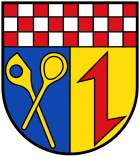
| Blazon : "Shield head red and white sheathed, underneath split by blue and gold, in front two diagonally crossed golden wooden spoons, in the back a red wolf tang." | |
|
Foundation of the coat of arms: The municipality of Damflos belonged to the "Lehen Züsch". Until 1716, the “Lehen Züsch” was a condominium between the rear county of Sponheim (1/3) and the Imperial Knighthood of the Barons of Hunolstein-Sötern (2/3). In 1716 the line of the barons of Hunolstein-Sötern died out. According to the will of January 4, 1712, the barons Eckbrecht von Dürckheim considered themselves to be heirs, who on May 31, 1720, also confirmed the ownership of the Söterische (2/3) of the Züsch dairy by the Imperial Court. (Fabricius p. 456/60).
This historical affiliation is reflected in the municipal coat of arms. In the head of the shield it shows the red and white chess of the Counts of Sponheim . The rear field of the split shield part shows the Sötern'sche Wolfsangel. Until around the Second World War, wood processing in the home industry was essential in Damflos. In particular, everyday items were made of wood. To distinguish between places with historically the same affiliation, but especially to remember the centuries-old home industry that was abandoned in modern times, the first field of the split shield shows two crossed, golden wooden spoons as a specific symbol of the Damflos community. |
The state archive of Koblenz has historically and heraldically approved the coat of arms with Vfg. St.A.Nr. I / 3246/71 of November 4th, 1971. The Damflos municipal council decided on November 27th, 1971 to introduce this coat of arms as the municipal coat of arms.
See also
Web links
- Homepage of the local community Damflos
- Damflos parish near the Hermeskeil parish
- To search for cultural assets of the local community Damflos in the database of cultural assets in the Trier region .
- Link catalog on Damflos at curlie.org (formerly DMOZ )
Individual evidence
- ↑ State Statistical Office of Rhineland-Palatinate - population status 2019, districts, communities, association communities ( help on this ).
- ↑ State Statistical Office Rhineland-Palatinate (ed.): Official directory of the municipalities and parts of the municipality. Status: January 2019 [ Version 2020 is available. ] . S. 117 (PDF; 3 MB).
- ↑ State Statistical Office Rhineland-Palatinate: My village, my city. Retrieved October 19, 2019 .
- ^ The Regional Returning Officer Rhineland-Palatinate: Local elections 2019, city and municipal council elections.
- ↑ Coat of arms of the Damflos community. Verbandsgemeinde Hermeskeil, accessed on October 19, 2019 .


