
Nittel
| coat of arms | Germany map | |
|---|---|---|

|
Coordinates: 49 ° 39 ' N , 6 ° 27' E |
|
| Basic data | ||
| State : | Rhineland-Palatinate | |
| County : | Trier-Saarburg | |
| Association municipality : | Conc | |
| Height : | 180 m above sea level NHN | |
| Area : | 16.68 km 2 | |
| Residents: | 2565 (Dec. 31, 2019) | |
| Population density : | 154 inhabitants per km 2 | |
| Postal code : | 54453 | |
| Primaries : | 06583, 06584 | |
| License plate : | TR, SAB | |
| Community key : | 07 2 35 095 | |
| LOCODE : | DE RFG | |
| Association administration address: | Am Markt 11 54329 Conc |
|
| Website : | ||
| Local Mayor : | Peter Leo Hein ( CDU ) | |
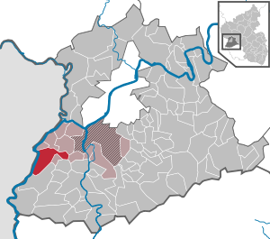
| Location of the local community Nittel in the district of Trier-Saarburg | ||
  |
||

_und_Machtum_(L).JPG)


Nittel an der Obermosel is a municipality in the district of Trier-Saarburg in Rhineland-Palatinate . She belongs to the Verbandsgemeinde Konz . The place, between dolomite and limestone cliffs , is a state-approved resort .
location
Nittel (without further districts: 1924 inhabitants, as of December 31, 2008) is located 24 km south of Trier on the Upper Moselle , which forms the border with Luxembourg here. On the opposite bank is the village of Machtum , which belongs to the municipality of Wormeldingen . The municipality includes the district of Rehlingen (180 inhabitants, as of December 31, 2008) located four kilometers south of the B 419 and the agricultural district of Köllig (153 inhabitants, as of December 31, 2008) on the plateau. The Höcht viewpoint ( 390 m above sea level ) is located between Nittel and Onsdorf .
history
The area of today's local community Nittel was demonstrably settled since the Stone Age. Numerous finds (clay vessels, belt buckles) attest to a Roman settlement around 2000 years ago.
Nittel was first mentioned under the name Nitele in a document from the year 1000 by the Archbishop of Trier , Ludolf . A copy of the original is in the city archive in Trier; it was exhibited on the occasion of the celebrations in 2000 in the community center in Nittel.
Over many centuries, Nittel experienced a very eventful history with frequent changes in the manorial conditions and associated with numerous armed conflicts. The place belonged temporarily to the Duchy of Lorraine , several times to France , to Luxembourg and thus to the Austrian Netherlands and finally came to Prussia after the Congress of Vienna . The people on the Upper Moselle experienced very bad times during the Thirty Years' War (1618–1648).
Köllig was first mentioned in 1030 as Coeltiche . The first documentary evidence of the current district of Rehlingen took place around the middle of the 12th century. For many centuries, the people of Nittel lived mainly from agriculture and viticulture.
On July 18, 1946, Nittel, together with 80 other municipalities in the districts of Trier and Saarburg , was annexed to the Saar area , which was separated from the rest of the French occupation zone in February 1946 and which was no longer subject to the Allied Control Council at the time . On June 6, 1947, this territorial separation was withdrawn to 21 municipalities, so Nittel came to the 1946 newly formed state of Rhineland-Palatinate .
On March 17, 1974, the previously independent communities Köllig and Rehlingen were incorporated.
politics
Municipal council
The local council in Nittel consists of 20 council members, who were elected in a personalized proportional representation in the local elections on May 26, 2019 , and the honorary local mayor as chairman.
The distribution of seats in the local council:
| choice | SPD | CDU | GREEN | FDP | UBN | FWG | Flat share 1 | total |
|---|---|---|---|---|---|---|---|---|
| 2019 | 4th | 7th | - | - | 3 | 4th | 2 | 20 seats |
| 2014 | 4th | 6th | - | - | 4th | 2 | - | 16 seats |
| 2009 | 3 | 5 | 2 | 1 | 3 | 2 | - | 16 seats |
| 2004 | 3 | 7th | - | - | 4th | 2 | - | 16 seats |
- UBN = Independent Citizens List Nittel e. V.
- FWG = Free Voter Group Nittel e. V.
mayor
From 2007 to 2014 Hans-Josef Wietor was the local mayor of Nittel. He had replaced Karl-Heinz Frieden . In 2014 Peter Leo Hein was elected the new local mayor.
coat of arms
The coat of arms of the municipality of Nittel from 1953 shows a lying sword in a red shield head, in the shield in silver a green mountain, covered with a silver wave bar.
economy
wine growing
Nittel is the center of the Elbling cultivation on the Upper Moselle. Approx. 25 wineries cultivate 290 hectares of vineyards, with Elbling accounting for 75%. The limestone soils and the almost Mediterranean climate give the wine a special touch, from which the Pinot Blanc and Pinot Gris also benefit. The Rochusfels , Hubertusberg , Leiterchen and Blümchen vineyards belong to Nittel .
tourism
There is a landing stage for Moselle shipping in Nittel. Hotels, restaurants and wineries with their taverns and wine taverns are geared towards tourism . The educational wine trail beneath an imposing limestone wall , hiking trails (500 hectares of forest belong to Nittel), two nature reserves ( Nittel rock with orchids ), the Rochus chapel and the Eberthälchen pond and recreation area are attractive to visitors .
Village newspaper

Nittel is the only place on the Upper Moselle to have its own newspaper, the “Darfscheel”. The "Darfscheel" is a village newspaper for Nittel, the districts of Köllig and Rehlingen and the Luxembourgish power on the opposite side of the Moselle, which appears three to four times a year with a circulation of around 1500 copies. The newspaper is politically and economically independent. It is distributed free of charge to all households in Nittel, Köllig, Rehlingen and Machtum. All employees and the authors work on a voluntary basis. Since October 29, 2010 the Darfscheel has been operating under the non-profit association “Darfscheel - Dorfzeitung Nittel e. V. "
The aim of the “Darfscheel” is to report on what is happening in the village, to maintain traditions, to promote a sense of community in the village and to offer the associations a forum for spreading news. To this end, she would like to stimulate discussions and reflect points of contention. Since the newspaper is not an official gazette or the like, there is no obligation to print official notices.
traffic

Nittel has a stop on the Thionville – Trier railway line . From here there are hourly connections with the regional train line RB 82 to Perl , Trier and Wittlich . Furthermore, the bus line 130/132 of the RGTR to Grevenmacher and Luxembourg stop every hour in Nittel , as well as the bus line 241 from Saarfürst-Reisen , formerly from the Moselbahn GmbH , in the direction of Saarburg , Wincheringen , Rehlingen and Temmels during school times . Bus line 241 and the railway are integrated into the Trier region transport network, while line 132 is subject to the tariffs of the Luxembourg Verkéiersverbond .
Celebrations and events
- Wine Trail Festival ( Holy Saturday )
- Open wine cellar days (May 1st weekend)
- St. Rochus wine fair and German-Luxembourgish wine happening (3rd weekend in August). Joint wine festival with the Luxembourg neighbors from Machtum with a boat shuttle across the Moselle. The 1st German-Luxembourgish wine happening was celebrated in 2006 and recognized by the Foreign Office in Berlin as a special European project. Traditionally, the wine fair starts on Friday with fireworks.
- Hobby and creative market
- Elbling trial day (November)
- Apres ski party on Christmas Day
- WineTime Nittel (March)
Attractions
- Rochus Chapel


- Location: The pilgrimage chapel St. Rochus is also called the Chapel of the Virgin Mary in the vineyards . The chapel stands in a cemetery in the middle of the Elbling vineyards above the village with a good view of the Moselle loop and the Luxembourg landscape opposite with the village of Wormeldingen.
- History: The chapel was built in 1432 by Pope Eugene IV. , A drain awarded by the age of 12, becoming first mentioned. In the course of its history it has been severely damaged several times by the effects of war, storm damage and lightning strikes, but has always been renovated or rebuilt. In the years 1701–1712 the interior of the chapel was created as an uneven space in Gothic-style shapes with an almost square choir . In 1865 a roof fire broke out after a lightning strike. Then the chapel received two new ogival portals, which, together with the coupled ogival windows, give the building the appearance of a neo-Gothic building.
- Significance: After the outbreak of a cholera epidemic around 1850, there were many pilgrimages to this chapel, which was often called the Marien or Bergkapelle . As a cultural object, the chapel is now one of the art monuments of Rhineland-Palatinate.
- Sculpture Path: Stones on the River - this is the name of a sculpture path with modern stone sculptures built in 2001 along the Upper Moselle. On the part that belongs to Nittel, there are the objects "knee with joint", "sign" and "waypoint".
- Roman brick kiln: During excavation work in 2000, a Roman brick kiln from the 2nd / 3rd centuries AD was used . Century exposed at the mouth of the Rehlinger Bach. Due to the location directly on the banks of the Moselle, the goods could easily be transported by ship downstream to Trier.
- Filial church St. Martin from 1770 high above the village ( location → )
- The nature reserves Nitteler Fels and Langheck near Nittel border the location .
See also: List of cultural monuments in Nittel
people
- Peter Joseph Hurth , CSC (1857-1935); Catholic diocesan bishop or titular archbishop in Asia.
- Carina Dostert (52nd German Wine Queen 2000/01)
- Dirk Bockel (Olympic participant in the triathlon 2008)
literature
- Georg Dehio : Handbook of the German art monuments. Rhineland-Palatinate, Saarland . German art publisher. Munich 1984. ISBN 3-422-00382-7 .
- Hans-Josef Wietor: The history of the place Nittel . Publication series Ortschroniken des Trier Land . 33. Nittel 2000.
- Hans A. Thiel: fords, ferry and barges across the Moselle between Nittel and Machtum. Nittel 2000.
Web links
- www.nittel-mosel.de
- 6305-302 Nitteler Fels and Nitteler Wald. (FFH area) Profiles of the Natura 2000 areas. Published by the Federal Agency for Nature Conservation .
- To search for cultural assets of the local community Nittel in the database of cultural assets in the Trier region .
- Link catalog on the subject of Nittel at curlie.org (formerly DMOZ )
Individual evidence
- ↑ State Statistical Office of Rhineland-Palatinate - population status 2019, districts, communities, association communities ( help on this ).
- ↑ State Statistical Office Rhineland-Palatinate - regional data
- ↑ Official municipality directory 2006 ( Memento from December 22, 2017 in the Internet Archive ) (= State Statistical Office Rhineland-Palatinate [Hrsg.]: Statistical volumes . Volume 393 ). Bad Ems March 2006, p. 191 (PDF; 2.6 MB). Info: An up-to-date directory ( 2016 ) is available, but in the section "Territorial changes - Territorial administrative reform" it does not give any population figures.
- ^ The Regional Returning Officer Rhineland-Palatinate: Local elections 2019, city and municipal council elections
- ↑ Darfscheel Nittel on the www. Retrieved October 11, 2015 .
- ↑ Season opening 2015. Heimat- und Verkehrsverein Nittel e. V., accessed on October 11, 2015 (Wine Trail Festival).
- ↑ WineTime Nittel. (No longer available online.) Archived from the original on January 23, 2016 ; accessed on January 23, 2016 . Info: The archive link was inserted automatically and has not yet been checked. Please check the original and archive link according to the instructions and then remove this notice.
- ↑ Entry on the Chapel of St. Roch and the Virgin Mary (Nittel) in the database of cultural assets in the Trier region ; accessed on October 11, 2015.
- ^ Ordinance on the "Nitteler Fels" nature reserve. (PDF) Trier-Saarburg district, October 5, 1998, accessed on March 30, 2017 .
- ^ Ordinance on the nature reserve "Langheck bei Nittel". (PDF) Trier-Saarburg district, September 17, 1998, accessed on March 30, 2017 .
- ↑ Map service. Federal Agency for Nature Conservation , accessed on March 30, 2017 .

Aach | Ayl | Baldringen | Bekond | Notification | Beuren (high forest) | Bonerath | Damflos | Detzem | Ensch | Farschweiler | Fur | Fish | Pine | Franzenheim | Freudenburg | Geisfeld | Greimerath | Grimburg | Gusenburg | Gusterath | Gutweiler | Heddert | Stalling | Herl | Hermeskeil | Hinzenburg | Hinzert-Pölert | Hockweiler | Holzerath | Hedgehog | Irsch | Kanzem | Chasuble | Kastel-Staadt | Kell am See | Kenn | Kirf | Klüsserath | Conc | Cord | Korlingen | Köwerich | Lampades | Langsur | Leiwen | Lunge | Longuich | Lorscheid | Mandern | Mannebach | Mehring | Mertesdorf | Merzkirchen | Morscheid | Naurath (Eifel) | Naurath (forest) | Neuhütten | Newel | Nittel | Upper cheap | Ockfen | Ollmuth | Onsdorf | Osburg | Palzem | Paschel | Pellingen | Pluwig | Pölich | Ralingen | Swift oath | Reinsfeld | Riol | Riveris | Saarburg | Schillings | Schleich | Schoden | Schömerich | Schondorf | Schweich | Serrig | Sommerau | Taben-Rodt | Tawern | Temmels | Thomm | Thörnich | Trassem | Trierweiler | Trittenheim | Vierherrenborn | Waldrach | Waldweiler | Wasserliesch | Wawern | Waves | Welschbillig | Wiltingen | Wincheringen | Zemmer | Zerf | Züsch