Ayl
| coat of arms | Germany map | |
|---|---|---|

|
Coordinates: 49 ° 38 ' N , 6 ° 33' E |
|
| Basic data | ||
| State : | Rhineland-Palatinate | |
| County : | Trier-Saarburg | |
| Association municipality : | Saarburg-Kell | |
| Height : | 148 m above sea level NHN | |
| Area : | 7.58 km 2 | |
| Residents: | 1544 (Dec. 31, 2019) | |
| Population density : | 204 inhabitants per km 2 | |
| Postal code : | 54441 | |
| Area code : | 06581 | |
| License plate : | TR, SAB | |
| Community key : | 07 2 35 002 | |
| LOCODE : | DE AYL | |
| Community structure: | 2 districts | |
| Association administration address: | Schloßberg 6 54439 Saarburg |
|
| Website : | ||
| Local Mayor : | Siegfried Büdinger | |
| Location of the local community Ayl in the district of Trier-Saarburg | ||
Ayl is a wine-growing village and a municipality in the district of Trier-Saarburg in Rhineland-Palatinate . It belongs to the Saarburg-Kell association.
geography
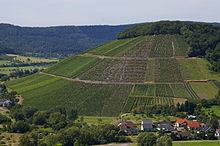
Ayl is located in a side valley of the lower Saar between the Mohlemskopf , a 321 m high hill north of Saarburg and the Ayler Kupp , a 251 m high mountain tongue with the famous vineyard of the same name.
The district of Biebelhausen belongs to Ayl. This is where the Biebelhausener Mühle is located, a traditional and nationally known large-scale bakery and pastry shop.
history
Ayl is the first time in 1052 as a rush called when Archbishop Eberhard von Trier a contract with the Count Walram of Arlon closes. Roman cremation graves from around the year 300 show, however, that Ayl was already settled at that time and housed a Roman fort .
From the middle of the 16th century until 1790 the Trier cathedral chapter was the sole landlord .
On July 18, 1946, Ayl and Biebelhausen, together with 79 other municipalities in the districts of Trier and Saarburg, were annexed to the Saar area , which was separated from the rest of the French occupation zone in February 1946 and which was no longer subject to the Allied Control Council at the time . On June 6, 1947, this territorial outsourcing was withdrawn to 21 municipalities, so Ayl and Biebelhausen came to the 1946 newly formed state of Rhineland-Palatinate .
Today's municipality of Ayl was created on June 7, 1969 through a new formation from the two previously independent municipalities Ayl (830 inhabitants) and Biebelhausen (234 inhabitants). Since 1970 she has been a member of the Saarburg Association .
- Population development
The development of the population of Ayl in relation to today's municipality, the values from 1871 to 1987 are based on censuses:
|
|
politics
Municipal council
The local council in Ayl consists of 16 council members, who were elected in a personalized proportional representation in the local elections on May 26, 2019 , and the honorary local mayor as chairman. The 16 seats in the local council are divided between the two groups of voters .
coat of arms
|
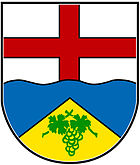
Blazon : "In a wavy cut divided by silver and blue, above a continuous red bar cross , below a rising golden tip , inside a green grape on the rear of two green vine shoots crossed at the ends, each with one leaf."
In some coats of arms the grape berries are filled with gold. |
|
| The reason for the coat of arms: The red cross in silver refers to belonging to Kurtrier , the wavy cut symbolizes the Saar and the golden peak in blue (mountain cone) with grapes indicates the most famous wine region of the place, the Ayler Kupp . |
Cultural monuments
- The Ayl Castle is a former Hofgut the Trier Cathedral Chapter. The building complex with residential building and wine press house has existed in its current form since 1897. A park with old trees follows.
- The Catholic parish church of St. Bartholomew is the work of Johann Claudius Lassaulx from 1846 to 1848. It houses a late Gothic stone baptism from around 1500 from the previous building.
- The Lambertskirchhof with its chapel and group of trees is located southeast of the village on the edge of the plateau that slopes down towards the Saar
Economy and Infrastructure
Ayl has always been a wine village. The Romans already cultivated wine on the slopes. The church chronicle shows the year 1289 as a good wine year. At the 1906 wine auction, a load of 1904 Ayler Kupp fetched the highest price ever paid for a Saar wine of 15,030 gold marks . At this auction there was also the so-called Trier wine auction case , which should employ generations of lawyers in civil law training.
Ayl belongs to the "Saar winegrowing area" in the Moselle growing region . There are 13 wine-growing businesses in the village, and the area under vines is 60 hectares. About 94% of the wine grown are white grape varieties (as of 2010).
- Vineyards
- Ayler Kupp
literature
- Ernst Wackenroder : The art monuments of the Saarburg district . (= Paul Clemen (Hrsg.): Die Kunstdenkmäler der Rheinprovinz , Volume 15, III. Department). L. Schwann, Düsseldorf 1939 (reprint from the Academic Bookshop Interbook, Trier 1982), 33–36.
- Literature about Ayl in the Rhineland-Palatinate State Bibliography
Web links
- Ayl on the website of the Saarburg-Kell association
- Short portrait of Ayl ( memento from January 11, 2014 in the web archive archive.today ) at Hierzuland , SWR television
- Brief portrait of Biebelhausen (Ayl) ( memento from January 11, 2014 in the web archive archive.today ) at Hierzuland, SWR television
- To search for cultural assets of the local community of Ayl in the database of cultural assets in the Trier region .
- Link catalog on Ayl at curlie.org (formerly DMOZ )
Individual evidence
- ↑ State Statistical Office of Rhineland-Palatinate - population status 2019, districts, communities, association communities ( help on this ).
- ↑ Biebelhausener Mühle: https://www.bhm.de/
- ↑ Official municipality directory 2006 ( Memento from December 22, 2017 in the Internet Archive ) (= State Statistical Office Rhineland-Palatinate [Hrsg.]: Statistical volumes . Volume 393 ). Bad Ems March 2006, p. 169 (PDF; 2.6 MB). Info: An up-to-date directory ( 2016 ) is available, but in the section "Territorial changes - Territorial administrative reform" it does not give any population figures.
- ↑ State Statistical Office Rhineland-Palatinate: My village, my city. Retrieved July 13, 2019 .
- ^ The Regional Returning Officer Rhineland-Palatinate: Local elections 2019, city and municipal council elections


