
Holzerath
| coat of arms | Germany map | |
|---|---|---|

|
Coordinates: 49 ° 41 ' N , 6 ° 46' E |
|
| Basic data | ||
| State : | Rhineland-Palatinate | |
| County : | Trier-Saarburg | |
| Association municipality : | Ruwer | |
| Height : | 427 m above sea level NHN | |
| Area : | 6.79 km 2 | |
| Residents: | 436 (Dec. 31, 2019) | |
| Population density : | 64 inhabitants per km 2 | |
| Postal code : | 54316 | |
| Area code : | 06588 | |
| License plate : | TR, SAB | |
| Community key : | 07 2 35 050 | |
| Association administration address: | Untere Kirchstrasse 1 54320 Waldrach |
|
| Website : | ||
| Local Mayor : | Friedbert Theis | |
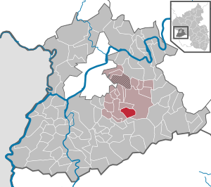
| Location of the local community Holzerath in the district of Trier-Saarburg | ||
  |
||

Holzerath ( Moselle Franconian : Holzröth ) is a municipality in the Trier-Saarburg district in Rhineland-Palatinate . It belongs to the Verbandsgemeinde Ruwer , which has its administrative headquarters in Waldrach .
geography
Holzerath is located in the Osburger Hochwald and in the Saar-Hunsrück Nature Park .
history
The place was first mentioned in a document in 1265, its name suggests the emergence of a clearing settlement. Today's local community Schöndorf was mentioned in 1569 as the parish of Holzerath. After the Thirty Years' War , the place Holzerath almost disappeared, it only comprised three fireplaces (approx. 15 to 20 inhabitants); the population recovered again in the following decades. In 1788 the place had 99 inhabitants and after the French occupation in 1794 it belonged to the Mairie and later Prussian mayor of Schöndorf . Later, Holzerath came to the Irsch-Schöndorf office in Wilzenburg , in 1934 to the Waldrach office in Ruwer and in 1954 to the Ruwer office , which in 1968 became the Ruwer community . In 1953 the place received a school, which today houses the day care center. The 750th anniversary of the town was held as part of the St. Helena fair in August 2015.
population
436 people live in Holzerath with their main residence and 15 with secondary residence (as of December 31, 2019).
The development of the population of Holzerath, the values from 1871 to 1987 are based on censuses:
|
|
politics
Municipal council
The municipality council in Holzerath consists of eight council members, who were elected in the local elections on May 26, 2019 in a majority vote, and the honorary local mayor as chairman.
Local mayor
- until 2014: Herbert Marth
- since 2014: Friedbert Theis, authorized signatory at a medium-sized company in Saarburg
coat of arms
Description of the coat of arms : "Under a silver shield head with Kurtrier cross , obliquely left divided by red over silver, above a golden crown, below a green beech leaf."
Until the end of the 18th century Holzerath belonged to the care Kell ( Amt Grimburg ) of the Electorate of Trier . Until 1563 the high judge was the elector of Trier. As an indication of this, the Electorate of Trier cross is in the head of the shield. Saint Helena has been the church and local patron since time immemorial . Her attribute, a golden crown, is in the middle part of the shield. The place name goes back in its second syllable -roth, -rath to the term clearing. For this and as an indication of the significant beech forests, there is a green beech leaf on the lower sign.
Culture and clubs
The volunteer fire brigade Holzerath, the Musikverein Holzerath, the Jugendring Holzerath and the TuS Holzerath are active in leisure and youth work .
The Roeds-Rock Open-Air-Festival at the Holzerather See am Grindelbach has been organized by the Jugendring Holzerath since 2007 .
Economy and Infrastructure
A number of small and medium-sized companies and a day-care center are located in Holzerath .
Holzerath is on the state road 146 (Schöndorf – Reinsfeld) and on the district road 56 in the direction of Bonerath.
See also
Web links
- Internet presence of the local community Holzerath
- To search for cultural goods of the local community Holzerath in the database of cultural goods in the Trier region .
- Link catalog on the subject of Holzerath at curlie.org (formerly DMOZ )
Individual evidence
- ↑ a b State Statistical Office of Rhineland-Palatinate - population status 2019, districts, municipalities, association communities ( help on this ).
- ^ History of Holzerath
- ^ Community population statistics
- ↑ State Statistical Office Rhineland-Palatinate - regional data
- ^ Verbandsgemeinde Ruwer
- ↑ Website of the Roeds-Rock Open Air-Festival ( Memento of the original from August 24, 2012 in the Internet Archive ) Info: The archive link was automatically inserted and not yet checked. Please check the original and archive link according to the instructions and then remove this notice.

Aach | Ayl | Baldringen | Bekond | Notification | Beuren (high forest) | Bonerath | Damflos | Detzem | Ensch | Farschweiler | Fur | Fish | Pine | Franzenheim | Freudenburg | Geisfeld | Greimerath | Grimburg | Gusenburg | Gusterath | Gutweiler | Heddert | Stalling | Herl | Hermeskeil | Hinzenburg | Hinzert-Pölert | Hockweiler | Holzerath | Hedgehog | Irsch | Kanzem | Chasuble | Kastel-Staadt | Kell am See | Kenn | Kirf | Klüsserath | Conc | Cord | Korlingen | Köwerich | Lampades | Langsur | Leiwen | Lunge | Longuich | Lorscheid | Mandern | Mannebach | Mehring | Mertesdorf | Merzkirchen | Morscheid | Naurath (Eifel) | Naurath (forest) | Neuhütten | Newel | Nittel | Upper cheap | Ockfen | Ollmuth | Onsdorf | Osburg | Palzem | Paschel | Pellingen | Pluwig | Pölich | Ralingen | Swift oath | Reinsfeld | Riol | Riveris | Saarburg | Schillings | Schleich | Schoden | Schömerich | Schondorf | Schweich | Serrig | Sommerau | Taben-Rodt | Tawern | Temmels | Thomm | Thörnich | Trassem | Trierweiler | Trittenheim | Vierherrenborn | Waldrach | Waldweiler | Wasserliesch | Wawern | Waves | Welschbillig | Wiltingen | Wincheringen | Zemmer | Zerf | Züsch