
Verbandsgemeinde Ruwer
| coat of arms | Germany map | |
|---|---|---|

|
Coordinates: 49 ° 45 ' N , 6 ° 45' E |
|
| Basic data | ||
| State : | Rhineland-Palatinate | |
| County : | Trier-Saarburg | |
| Area : | 126.6 km 2 | |
| Residents: | 18,467 (Dec. 31, 2019) | |
| Population density : | 146 inhabitants per km 2 | |
| License plate : | TR, SAB | |
| Association key : | 07 2 35 5004 | |
| Association structure: | 20 municipalities | |
| Association administration address : |
Untere Kirchstrasse 1 54320 Waldrach |
|
| Website : | ||
| Mayoress : | Stephanie Nickels ( CDU ) | |
| Location of the Verbandsgemeinde Ruwer in the Trier-Saarburg district | ||
  |
||

The Verbandsgemeinde Ruwer is a Rhineland-Palatinate association in the district of Trier-Saarburg and is located southeast of the independent city of Trier in the Moselle-Franconian- speaking area. The area is characterized by the millennia-old wine culture landscape of the lower Ruwertal as well as the wooded foothills of the Hunsrück that rise to the left and right of the Ruwer into the Osburger Hochwald and the Schöndorfer parish .
geography
Geographical location
The Verbandsgemeinde Ruwer is mainly located in the area of the natural landscape units Lower Ruwertal , Ruwerengtal , Osburger Hunsrück and Osburger Hochwald , partly also in the area of the Pellingen plateau , the Tarforster plateau and the Leiwener Moselle rim heights .
The altitude of the municipality area ranges from about 135 m above sea level. NHN near Mertesdorf up to 708 m above sea level. NHN on the roaster near Osburg . The right Moselle tributary Ruwer rises at the foot of the Rösterkopf .


The community is mainly located in the water catchment area of the Ruwer with its tributaries, especially the Riveris . The eastern part of the Verbandsgemeinde lies in the catchment area of the Feller Bach with backwaters, smaller areas are in the Wadrill (Prims) area in the southeastern part of the Osburg district, in the Olewiger Bach area near Ollmuth and in the Meierbach (Moselle) area near Mertesdorf .
Neighboring municipalities
Neighboring municipalities are clockwise (starting in the north):
- Longuich , Fell and Mehring in the area of the Verbandsgemeinde Schweich on the Roman Wine Route
- Notification , Beuren and Reinsfeld in the area of the Hermeskeil community
- Kell am See , Schillingen , Heddert and Lampaden in the area of the Saarburg-Kell association
- Pellingen in the area of the Verbandsgemeinde Konz
- Franzenheim and Hockweiler in the area of the Trier-Land association
- Trier-Irsch , Trier-Filsch , Trier-Tarforst , Trier-Kürenz and Trier-Ruwer / Eitelsbach in the area of the city of Trier
Association members communities
| Surname | Area in km² |
Mean Height in m |
1563 Feuerst. |
1684 Feuerst. |
1815 inhabitants |
1950 inhabitants |
2000 inhabitants |
December 31, 2019 residents |
|---|---|---|---|---|---|---|---|---|
|
|
4.25 | 424 | 6th | 6th | 151 | 221 | 246 | 233 |
|
|
7.45 | 433 | 13 | 8th | 197 | 531 | 748 | 828 |
|
|
4.41 | 301 | 5 | 9 | 141 | 339 | 1.915 | 2,025 |
|
|
2.51 | 305 | 7th | 7th | 100 | 291 | 711 | 657 |
|
|
2.83 | 420 | 5 | 7th | 140 | 199 | 231 | 261 |
|
|
2.87 | 328 | 3 | 3 | 82 | 163 | 158 | 136 |
|
|
6.79 | 427 | 6th | 5 | 186 | 326 | 472 | 436 |
|
|
4.53 | 166 | 25th | 21st | 255 | 1,029 | 1,272 | 1,333 |
|
|
2.08 | 287 | 9 | 6th | 97 | 194 | 843 | 822 |
|
|
5.09 | 439 | 25th | 12 | 187 | 444 | 580 | 524 |
|
|
6.47 | 199 | 20th | 14th | 287 | 990 | 1,681 | 1,670 |
|
|
5.48 | 282 | 17th | 18th | 227 | 526 | 822 | 935 |
|
|
3.92 | 330 | 4th | 4th | 91 | 174 | 162 | 156 |
|
|
32.92 | 456 | 23 | 17th | 515 | 1,227 | 1.938 | 2,412 |
|
|
4.87 | 310 | 9 | 9 | 250 | 657 | 1,163 | 1,681 |
|
|
2.11 | 209 | 4th | 4th | 133 | 286 | 366 | 411 |
|
|
10.03 | 309 | 12 | 12 | 296 | 716 | 820 | 789 |
|
|
1.04 | 194 | 1 | 1 | 29 | 111 | 70 | 68 |
|
|
4.49 | 462 | 16 | 12 | 327 | 707 | 997 | 1,066 |
|
|
12.46 | 159 | 53 | 41 | 533 | 1,649 | 2,043 | 2,024 |
|
|
126.60 | ø 322 | 263 | 216 | 4.224 | 10,780 | 17,238 | 18,467 |
Parish parts
The municipalities also belong to the municipalities belonging to the association


- Langeichhof ( Bonerath )
- Backeshof, Birkenhof, Forsthaus Farschweiler, Klostermühle / Gehrensmühle ( Farschweiler )
- Romika ( Gusterath )
- Romika ( Gutweiler )
- Coffee grinder ( Herl )
- Hinzenburg Mill ( Hinzenburg )
- House Timpert ( chasuble )
- Korlinger Mill ( Korlingen )
- Scholersmühle ( Lorscheid )
- Railway stop Grünhaus-Mertesdorf , Lorenzhof, Maximin Grünhaus ( Mertesdorf )
- Herrgottsmühle, Im Lonschenberg, Lichtenthalsmühle (formerly City of Trier ), Marienlay Castle , Studentenmühle ( Morscheid )
- Forsthaus Sternfeld, Neuhaus ( Osburg )
- Pluwig railway station , Geizenburg , Pluwigerhammer , Willmerich , Wilzenburg ( Pluwig )
- Feilensmühle, Karlstollen ( Riveris )
- Lonzenburg , Neuhof , Pluwigerhammer , Raulsmühle , Schöndorferheide ( Schöndorf )
- Althinkelhaus , Neuhinkelhaus , Thommerberg ( Thomm )
- House Kampf, grinding mill , smelting mill ( Waldrach )
climate

The annual precipitation at the measuring station of the German Weather Service in Mertesdorf in the Ruwertal was 760 mm in the period from 1961 to 1990.
Spatial planning
The closest regional center is the independent city of Trier . The municipalities of Waldrach and Osburg form a basic central supply area with a division of functions. Surrounding basic or medium- sized centers are Reinsfeld , Kell am See , Zerf , Schweich and Hermeskeil .
history


The locations of the association of municipalities included in Kurtrier time to Office Pfalzel , the Office Maximin , the official St. Paulin , the Office Grimburg or other dominions. These offices were divided into foster care. At the end of the 18th century, Waldrach's care in the Pfalzel district included Bonerath , Eitelsbach , Farschweiler , Filsch , Gutweiler with Sommerau , Hinzenburg , Hockweiler , Irsch , Kasel , Korlingen , Morscheid , Osburg , Riveris , Schöndorf , Thomm and Waldrach .
During the French period , the Mairien were built in Ruwer , Farschweiler , Schöndorf and Irsch . In Prussian times these were converted into the mayor's offices of Ruwer , Farschweiler , Schöndorf and Irsch . At the end of the 19th century, the mayorships of Irsch and Schöndorf were combined to form the mayor's office of Irsch-Schöndorf in Wilzenburg . At the beginning of the 20th century, the mayor's offices were renamed.
When the offices in the Trier region were reorganized, the Waldrach office in Ruwer was formed in 1934 . The former Amt Ruwer , which consisted of only seven parishes, got 14 new parishes. In 1954 the office was renamed to Amt Ruwer again and on October 1, 1968 it was converted into an association municipality . The municipalities of Ruwer and Eitelsbach were incorporated into the city of Trier on June 7, 1969 as part of a municipal reorganization and have formed the municipality of Ruwer / Eitelsbach since 1974 . The community Hinzenburg came on November 7, 1970 from the collective community Kell to the collective community Ruwer.
The construction of the new town hall of the Verbandsgemeinde Ruwer began in March 2004 in Waldrach and was officially put into operation in November 2005. The new tourist information office of the association in Kasel was handed over to its intended purpose in the summer of 2006 and in 2009 was recognized by the Rhineland-Palatinate advisory board of the ServiceQualität Deutschland initiative as a “quality company level 1” and “quality company of the Mosel umbrella brand ”.
Religions

70 percent of the population of the Verbandsgemeinde belong to the Roman Catholic Church in the Diocese of Trier , 9 percent of the Protestant ones in the Evangelical Church in the Rhineland , 2 percent of another religious community and 19 percent are unspecified or have no community.
- Churches
- Catholic parishes in the dean's office Hermeskeil-Waldrach are: Mariä Heimsuchung , Farschweiler; St. Cosmas and Damian , Gutweiler; St. Nicholas , chasuble; St. Gertrud , Lorscheid; St. Martin , Mertesdorf; St. Martin , Morscheid; St. Clemens , Osburg; St. John the Baptist , Pluwig; St. Andreas , Schöndorf; St. Pauli Conversion , Thomm; St. Laurentius , Waldrach;
- These include the Catholic branch churches: St. Arnulf and St. Margarethe , Bonerath; St. Martin , Gusterath; St. Quirinus , Herl; St. Magdalena , Hinzenburg; St. Helena , Holzerath; St. Valentin , Korlingen; St. Thomas , Ollmuth; St. Cornelius , Riveris;
- Evangelical : Ev. Gusterath parish hall, Johannes Church in Grünhaus / Mertesdorf ;
- New Apostolic : New Apostolic Congregation Mertesdorf (since 1939).
Population development
According to the Trier fire book , there were 249 fireplaces in the area of the Verbandsgemeinde Ruwer in 1563 (corresponds to about five to six residents per fireplace) and in 1684 there were 216 fireplaces.
The development of the number of inhabitants in relation to the area of today's Verbandsgemeinde Ruwer; the values from 1871 to 1987 are based on censuses:
|
|
Graphic of the population development

|
On December 31, 2019, there were 19,134 main and secondary residences in the Ruwer community.
politics
The Verbandsgemeinde belongs to the Bundestag constituency of Trier and the Landtag constituency of Trier / Schweich . Other regional and institutional assignments are the Trier District Court , the Trier Regional Court , the Koblenz Higher Regional Court , the Trier Tax Office , the Trier Chamber of Commerce and Industry , the Trier Chamber of Crafts , the Westeifel-Mosel Survey and Cadastre Office, the Trier Service Office and the Trier Employment Agency . The Verbandsgemeinde and all local parishes of the Verbandsgemeinde are members of the Rhineland-Palatinate Association of Municipalities and Cities .
Association municipal council
The Ruwer municipal council consists of 32 honorary council members who were elected in a personalized proportional representation in the local elections on May 26, 2019 , and the full-time mayor as chairman.
The distribution of seats in the municipal council:
| choice | SPD | CDU | GREEN | FWG | total |
|---|---|---|---|---|---|
| 2019 | 11 | 10 | - | 11 | 32 seats |
| 2014 | 9 | 12 | 3 | 8th | 32 seats |
| 2009 | 9 | 12 | 3 | 8th | 32 seats |
| 2004 | 8th | 14th | 2 | 8th | 32 seats |
| 1999 | 10 | 15th | 2 | 5 | 32 seats |
| 1994 | 12 | 15th | - | 5 | 32 seats |
- FWG = Free Voting Group Verbandsgemeinde Ruwer e. V.
The Council of Elders is a committee of the Ruwer municipal council . A youth representative has been set up. Further committees of the municipal council according to the main statutes are the main and finance committee, the building, environment and planning committee, the auditing committee, the youth, sports and social committee, the tourism, culture and viticulture committee, the wastewater works committee and the school board committee .
mayor
- 1917–1937: Eduard Voss
- 1938–1945: Josef Jost
- 1945–1946: Josef Koster
- 1946–1961: Karl Rittel
- 1961–1965: Walter Steffens
- 1965–1996: Hermann Feldges, recipient of the Federal Cross of Merit on ribbon
- 1996–2017: Bernhard Busch
- since 2018: Stephanie Nickels
The first direct election of a mayor took place on October 22, 1995. Klaus Longen (CDU) received 42.85% of the votes, Helmut Striethorst (SPD) received 14.29% and Bernhard Busch (FWG) received 42.86%. The turnout was 60.57%. In the required runoff on November 5, 1995, Bernhard Busch prevailed with 68.33% against Klaus Longen (31.67%) with a turnout of 65.12%. Bernhard Busch was thus elected for a term of office from March 1, 1996 to February 29, 2004.
On June 29, 2003 the next mayoral election took place. Wolfgang Annen (CDU) got 26.55% of the votes, Jürgen Breiling (SPD) 10.43% and Bernhard Busch (FWG) 63.02%. The turnout was 58.89%. Bernhard Busch was thus elected for a further eight years.
In the mayoral election on June 19, 2011, incumbent Bernhard Busch (FWG) won with 66.5% of the votes, ahead of Mechthild Michels (GREEN) with 19.4% and Sascha Hermes (CDU) with 14.1% and was thus for another eight Years in office confirmed. The turnout was 41.2%. Mayor Busch was retired by the Trier-Saarburg district administration at the end of July 2017.
On November 19, 2017, Stephanie Nickels (CDU) was elected as the new mayor of VG Ruwer in a runoff election. She got 52.7% of the valid votes, Stefan Metzdorf (SPD) got 47.3%. The turnout was 43.2%. In the first election on November 5, 2017, there were still five candidates.
Alderman
Deputy Mayor were to June 2014, the Assistant Secretary- Günter Jacob ( CDU ) and Karl-Heinrich Ewald ( SPD ). On June 18, 2014, Karl-Heinrich Ewald (SPD) were elected as first alderman and Josef Kruft ( FWG ) as further alderman of VG Ruwer. On June 19, 2019, Stefan Metzdorf (SPD) was elected as the new first alderman and Daniel Philippi (FWG) as the new further alderman of VG Ruwer.
badges and flags
|
|
Blazon : “The coat of arms is divided. Above in gold a half, double-headed black, red armored eagle with a heart shield . In it, in blue, a silver bear striding to the right, accompanied by a six-pointed silver star at the top left. Below in green an oblique left wavy band , on the top right accompanied by a silver vine stalk with a silver grape and a silver leaf, on the bottom left accompanied by a silver ax and a silver shovel that cross each other. " |
| Founding of the coat of arms: The place Ruwer, which was the seat of the Verbandsgemeinde Ruwer until October 2005, belonged from the Middle Ages to the end of the 18th century to the property of the St. Maximin Abbey in Trier , which as a sign of its imperial immediacy, the double-headed imperial eagle with a heart shield in the coat of arms led. In the heart shield appears a bear with a star, which plays a role in the iconography of St. Maximin. In the lower half of the coat of arms, the wavy band indicates the Ruwer as the dominant river of the landscape, in which viticulture - embodied by the grape - agriculture - embodied by the shovel - and forestry - embodied by the ax - play the main economic roles. The original coat of arms is located in the town hall of the Verbandsgemeinde in Waldrach and bears the signature H. Leitermann , 1968 . |
|
|

|

|
Since the beginning of 2006, the municipality has been flying a flag in the Electorate of Trier colors red and white with the coat of arms in the upper third. It stands together with the European flag and the state flag of Rhineland-Palatinate in front of the town hall in Waldrach. |
Local partnership
Since May 2013, the association has had a municipal partnership with the Polish Gmina Kosakowo in Powiat Pucki , Pomerania .
household
In 2010, the association's budget was changed from cameralist to double-entry accounting . Since 2017, the budget is as participatory budgeting out. The debts of the Verbandsgemeinde Ruwer amount to € 9,761,796 (€ 530 per inhabitant) and that of the municipal area (association and its local communities) € 20,563,778 (€ 1,116 per inhabitant).
Culture and sights

- Evidence from prehistory and early history are the menhirs near Thomm / Waldrach and near Farschweiler , the large stone grave of three murderers near Bonerath / Holzerath, the princely grave of Thomm , the Fliehburg on the Naumeter Kopf near Waldrach / Korlingen and the Burgkopf near Lorscheid / Fell.
- Evidence from Roman times are the remains of the original Roman Ruwer water pipe in Waldrach and the replica of the Roman water pipe in Waldrach an der Straße der Römer , the remains of a Roman stone mill in Mertesdorf, the relief winegrower in the Weinkontor in Mertesdorf and the Roman camp near Holzerath.
- Historic buildings are the castle ruin Sommerau from the 13th century, the Marienlay Castle near Morscheid, the Grünhaus Castle near Mertesdorf, the monastery and collegiate courts in Kasel, the Gusterath home and town house and the Pluwiger Hammer .
- Art-historical sights are the tabernacle altar (wooden altar) in chasuble, the side altar in Waldrach, the Vesper picture in Pluwig, the Passion pictures in Osburg, the Way of the Cross near Farschweiler, the Gothic church in Gutweiler, the chapel in Korlingen with the representation of the 14 Holy Helpers , the chapel with tabernacle altar in Ollmuth, the classicist church in Schöndorf and the church in Thomm ( Devonian slate ).
- Quartzite rocks are the Herler Wacken on the Schiefer-Wackenweg , the Herler Felsen , the Langenstein near Morscheid / Riveris, the Seiferingstein near Hinzenburg and the Spitzenstein and the Fischhuffelsen near Hinzenburg.
- Natural monuments are the thick oak and the two linden trees near Gusterath, the old oak in Gutweiler, the oak near Lorscheid, the oak near Schöndorf, the white poplar near Mertesdorf and the holly stock near Osburg. More forest thistles (holly) can be found on the Rascheiderweg in the Farschweiler Forest. An educational forest trail with 22 stations ( forest thistle trail ) has been leading there since spring 2010 .
- A bunker from the Second World War is located southeast of Osburg near Landesstrasse 151 on the Grünbrücherschneise . Further bunker ruins are located on the Grüneberg near Mertesdorf.
- Modern times: the Riveristalsperre near Riveris, the place of our German Wine Queen in Waldrach and the vineyard sculpture hiking trail in the Ruwertal.

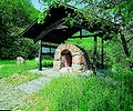
Menhir near Thomm / Waldrach
Replica of the Roman Ruwer water pipeline


Events

The Ruwer-Riesling e. V. organizes various events such as the days of the open wine cellars in the Ruwertal, the Ruwertal spring on Whitsunday in the vineyards between Kasel and Mertesdorf, the Ruwer wine festival or the October wine festival.
In addition to the carnival events , fairgrounds , parish and club festivals , Christmas markets and other events, the Karl May Festival in Pluwig or the Ruwer Riesling run on the bike path between Mertesdorf and Waldrach should be emphasized .
Special stages of the Rallye Deutschland , which has been held as a run to the World Rally Championship since 2002 , have been running (with interruptions) through the territory of the Verbandsgemeinde since 2000. From 1971 to 2011 the Trier hill climb was held between Fell and Thomm . The car-free Sunday Ruwertal aktiv was held from the beginning of the 1990s to 2012 in the lower Ruwertal.
The road bike race Deutschland Tour 2018 led in August 2018 with the 2nd stage (Bonn-Trier) coming from Lorscheid via Herl, Thomm, Waldrach and Korlingen to Trier.
Economy and Infrastructure


The economy is characterized by agriculture and forestry, viticulture and tourism, historically also by slate mining in the Ruwer , Riveris and Noßertal and ore mining (near Pluwig ). The needs of older and sick people coming DRC - welfare center against in Waldrach that the tasks of a maintenance support point perceives. Retirement homes are located in Lorscheid and since 2013 also in Pluwig.
Various industrial, craft, trade and service companies as well as several agricultural and wine-growing companies are located here . Are wineries such as the winery Maximin Green House , the estate heirs of Beulwitz which Weingut Karlsmühle , the Dominican winery C. von Nell-Breuning , or the estate empire von Kesselstatt .
There are industrial and commercial areas in Gusterath-Tal , Osburg-Neuhaus , Waldrach and others. The central landfill of the Trier waste management association with the mechanical-biological waste drying plant completed in 2007 is located at Landesstraße 151 near Mertesdorf .
Between Mertesdorf and Trier-Kürenz is located on Green Mountain , the Bundeswehr Technical Center 41 of the Bundeswehr .
Landesstraße 151 (formerly Bundesstraße 52 ) and other state, district and municipal roads run through the territory of the Verbandsgemeinde . The closest motorways are the A 602 ( Trier - AD Moseltal ) at Kenn , the A 64 at Trier-Ehrang, which leads to Luxembourg , and the A 1 with the junctions AD Moseltal and Reinsfeld (Hochwald).
The places of the Verbandsgemeinde are in the area of the transport association Region Trier , the next largest train station is Trier Hbf . There is a Moselle harbor in Trier-Ehrang . The nearest airports are in Luxembourg , Hahn and Saarbrücken .
There are branches or branches of the Sparkasse Trier , Volksbank Trier and Postbank in various municipalities of the Verbandsgemeinde .
Land use: The total floor area is 126.6 km² , of which agricultural area 32.0%, forest area 50.3%, water area 0.6%, settlement and traffic area 11.6%, other areas 5.5%.
Wind turbines are located on the heights between Gusterath and Trier-Irsch ( Kuppensteiner Wild ) and between Waldrach and Fell (on state road 151).
tourism


- In the Ruwertal , the Ruwer-Hochwald-Radweg was built from 2005 to 2009 on the route of the former Hochwaldbahn .
- Two stages of the Saar-Hunsrück-Steig hiking trail lead through the territory of the Verbandsgemeinde, namely stage 26 with a length of 20.2 km ( reservoir Kell - Bonerath - Riveris - Waldrach - Kasel / Mertesdorf) and stage 27 (Kasel - Filsch - Trimmelter Hof ) with a length of 15.3 km. Dream loops on the Saar-Hunsrück-Steig are the premium hiking trails Schiefer-Wackenweg near Thomm , Herl and Fell (12 km), the Morscheider Grenzpfad near Morscheid (13.5 km) and the Roman Celtic path near Farschweiler and Lorscheid (13 km). In May 2014 the Romika-Weg (10.4 km) at Gusterath-Tal, Gusterath, Pluwig and Lonzenburg was completed and in September 2015 the Trier gallows-head tour (15.5 km) at Korlingen, Tarforst, Filsch and Irsch, which goes over the Galgenkopf and the Korlinger Wacken leads to the Naumeter Kopf . The Ausoniusweg from Bingen am Rhein to Trier leads from Fell through Mertesdorf to Trier as well as the Hunsrücker Jakobsweg, which runs on the same route .
- One tourist route is the Ruwer-Riesling-Route ( Ruwer-Riesling-Weinstrasse ) through the Ruwertal.
- State-recognized resorts are the Ruwertal communities Mertesdorf and Waldrach.
- In addition to the signposted hiking trails in the Ruwer- and Riveristal and in the Osburger Hochwald, the barefoot trails on a hiking trail between Pluwigerhammer and the Raulsmühle and in Riveris at the water treading basin , pétanque courts in Farschweiler, Gusterath, Holzerath, Kasel, Korlingen, Morscheid, Osburg and Thomm, the Falkenstation in Schöndorf, fitness studios in Mertesdorf and Osburg-Neuhaus , the outdoor pool "Ruwertal" in Mertesdorf or the leisure facility near Holzerath on the reservoir at Grindelbach . Grill huts are in Gusterath, Holzerath, Lorscheid, Ollmuth, Osburg, Pluwig, Riveris and Thomm, bowling alleys in Gusterath Valley , Korlingen, Osburg, Pluwig, Riveris, Schöndorf and Thomm, sports fields in the local communities Farschweiler, Gutweiler, Kasel, Lorscheid, Mertesdorf, Morscheid, Osburg, Pluwig, Schöndorf, Thomm and Waldrach. Tennis courts are in Gusterath, Gutweiler, Kasel, Mertesdorf, Osburg and Waldrach. There is also a tennis hall in Kasel. There are volleyball facilities in Kasel, Korlingen, Mertesdorf, Osburg and Pluwig. There are water treading pools in Farschweiler on the main road / Unterm Wehlenkopf, in Holzerath at the leisure facility on the reservoir, in Morscheid near Praßwies and in Riveris below the dam at the forest festival area. For the hobby of geocaching there are numerous hiding places (geocaches) in the area of the association.
media
Local media are the Trierische Volksfreund , historically also the Trierische Landeszeitung (until 1974), and the Mosel-Ruwertaler Wochenspiegel (since 1984). The bulletin of the Verbandsgemeinde Ruwer appeared in 1971 and from 1974 as the official gazette of the Verbandsgemeinde Ruwer . Since 1999 it has also contained the notifications, information and official notices of the Trier-Saarburg district administration . Another medium since 1998 has been the website of the Ruwer Association, ruwer.de .
Public facilities


There are 20 local fire brigades and several youth fire brigades in the area of the Verbandsgemeinde . From 1987 to 2013, Josef Hartmann, who was awarded the Golden Fire Brigade Decoration on Ribbon by District Administrator Günther Schartz , was the defense chief of the Ruwer community . His successor was Christian Kühn from Pluwig until March 2016. Frank Rohde from Kasel has been the military director of the association since May 2016.
The fire brigade operations center of the Verbandsgemeinde Ruwer is set up in the fire station of the Waldrach volunteer fire brigade . The vehicles ELW 1 , LF 8 , LF 20/16 and DLK 16/4 are available in Waldrach .
Other public facilities are the school gyms in Gusterath, Schöndorf and Waldrach as well as the Altenberghalle in Gutweiler, the Ruwertalhalle in Mertesdorf and the Pluwig sports hall. The foundation stone for the new multi-purpose sports hall in Osburg was laid on December 8, 2010, and the hall was inaugurated on March 31, 2012.
The supply of drinking water to the drinking water regulations made by the purpose association waterworks Ruwer for all the municipalities in the municipality until Gutweiler, Korlingen and Sommerau by the public utilities registers are supplied. In addition, the Trier districts of Ruwer and Eitelsbach as well as the communities Franzenheim and Hockweiler in the area of the Verbandsgemeinde Trier-Land and Pellingen (in the Verbandsgemeinde Konz ) receive water from the Ruwer waterworks. From the four water treatment plants in Holzerath, Lorscheid, Osburg and Riveris, the water is directed to the 14 elevated water tanks with a total of 8,830 m³ total storage volume and then distributed to the local networks. The water hardness in the area of the waterworks is soft . For the sanitation in the municipality which is self-propelled sewage plant Ruwer responsible. The wastewater is clarified in the Ruwertal sewage treatment plant and in the Farschweiler / Herl and Lorscheid sewage ponds.
The Zweckverband Freibad Ruwertal has the task of operating and maintaining the outdoor swimming pool in Mertesdorf , which has existed since 1967 . He belongs to the Verbandsgemeinde Ruwer and the city of Trier. The outdoor pool has a 50 m swimmer's pool with a diving tower , a non-swimmer pool with a slide and waterfall, a paddling pool with play equipment and a garden restaurant.
The special purpose cemetery associations Gutweiler (for the communities Gutweiler, Korlingen and Sommerau) and Schöndorf (for the communities Bonerath, Hinzenburg, Holzerath, Ollmuth and Schöndorf) are administered by the Verbandsgemeinde and fulfill the tasks according to the funeral law .
A little more than half of the area of the Verbandsgemeinde is forested. The responsible forestry offices are the Hochwald Forestry Office in Dhronecken and the Trier Forestry Office in the forester's house in Quint .
The Verbandsgemeinde Ruwer is divided into three arbitration districts: Waldrach, Osburg and Pluwig.
education
The primary schools in Farschweiler, Gusterath-Pluwig, Mertesdorf-Kasel, Osburg, Schöndorf and Waldrach as well as the Realschule plus in Waldrach are located in the community . Some of the schools are set up as all-day schools . Branch offices of the adult education center are in Gusterath, Gutweiler, Kasel, Mertesdorf, Osburg and Waldrach. There are community or church day-care centers in Gusterath, Gutweiler, Holzerath, Kasel, Lorscheid, Mertesdorf, Morscheid, Osburg, Pluwig, Thomm and Waldrach. Secondary schools are located in the surrounding cities of Trier , Schweich and Hermeskeil .
literature
- Willi Blum: Natural and cultural monuments in the Verbandsgemeinde Ruwer , publisher: Volkshochschule, Trier 1978.
- Vom Caseler Pitt and the Hütten Marei - stories and history from the Ruwertal and the front high forest , publisher: Volkshochschule Verbandsgemeinde Ruwer, 1991.
- Ewald Wegner (arrangement): District of Trier-Saarburg. Verbandsgemeinden Ruwer, Schweich, Trier-Land (= monument topography Federal Republic of Germany , cultural monuments in Rhineland-Palatinate . Volume 12.2 ). Wernersche Verlagsgesellschaft, Worms 1994, ISBN 3-88462-110-6 .
- Tobias Blasum, Hermann Bonert: Fallen fortresses: The end of the Second World War in the Osburger Hochwald and in the Ruwertal . Kieselkaul-Verlag Osburg, 2016. ISBN 978-3-00-054815-4 .
- Literature about Verbandsgemeinde Ruwer in the Rhineland-Palatinate state bibliography
Web links
- Website of the Verbandsgemeinde Ruwer
- Website of the Ruwer Tourist Information Office
- Official journal of the Verbandsgemeinde Ruwer
- Link catalog on the topic of the Ruwer Association at curlie.org (formerly DMOZ )
- Manfred Bales: Moselle Franconian dictionary - dialect as it is still spoken in the VG Ruwer. (Private website).
Individual evidence
- ↑ a b c State Statistical Office Rhineland-Palatinate - population status 2019, districts, municipalities, association communities ( help on this ).
- ↑ a b Nature Conservation Administration Rhineland-Palatinate
- ^ Rhineland-Palatinate water management administration
- ↑ State Statistical Office Rhineland-Palatinate (ed.): Official directory of the municipalities and parts of the municipality. Status: January 2018 [ Version 2020 is available. ] . S. 76 f . (PDF; 2.2 MB).
- ↑ Trierische Chronik / Zeitschr. d. Society for Trier History and Monument Preservation
- ↑ Through the state law amending municipal constitutional regulations and preparing for the reorganization of municipalities of July 16, 1968, the new association municipality order was enacted and at the same time the official order in force since 1948 was repealed. The law came into force on October 1, 1968.
- ↑ a b Municipal statistics, reference date: December 31, 2019
- ↑ State Statistical Office Rhineland-Palatinate - regional data
- ^ The Regional Returning Officer Rhineland-Palatinate: Local elections, association council elections
- ↑ Main statute of the Verbandsgemeinde Ruwer from September 25, 2019 in the official gazette of VG Ruwer, edition 40/2019, p. 5
- ^ Result of the election of mayor VG Ruwer 2011
- ↑ Results of the mayoral election on November 5, 2017
- ↑ Results of the mayoral election (runoff) on November 19, 2017
- ↑ Debt 2018, State Statistical Office Rhineland-Palatinate
- ^ Trierischer Volksfreund
- ↑ Elderberry Bush Nursing Home
- ↑ Pluwig Senior Center
- ↑ Saar-Hunsrück Climb: Stages
- ^ Catalog of the German National Library
- ↑ Press release from the Trier-Saarburg district administration
- ↑ Overloaded - fire chief Kühn leaves, Verbandsgemeinde Ruwer is looking for a new fire chief , report in Trierischer Volksfreund
- ↑ Change of military leader in the Verbandsgemeinde Ruwer , report in the Trierischer Volksfreund
- ↑ Waldrach fire brigade
- ^ Trierischer Volksfreund
- ^ Trierischer Volksfreund: Hochwaldhalle in Osburg inaugurated
- ↑ Ruwertal outdoor pool
- ↑ gefallene-festungen.de
